Report on Unzendake (Japan) — January 1993

Bulletin of the Global Volcanism Network, vol. 18, no. 1 (January 1993)
Managing Editor: Lindsay McClelland.
Unzendake (Japan) Continued dome growth generates pyroclastic flows and avalanches
Please cite this report as:
Global Volcanism Program, 1993. Report on Unzendake (Japan) (McClelland, L., ed.). Bulletin of the Global Volcanism Network, 18:1. Smithsonian Institution. https://doi.org/10.5479/si.GVP.BGVN199301-282100
Unzendake
Japan
32.761°N, 130.299°E; summit elev. 1483 m
All times are local (unless otherwise noted)
The lava dome complex's shape remained relatively unchanged throughout December and January. On 1 February, fresh, massive lava blocks began to appear from the west-central part of the dome complex, which had continued to swell during the last week of January. The swelling event was accompanied by frequent volcanic earthquakes. The lava blocks grew to form a new lava dome (dome 10) by 3 February (figure 48). Peel structure, consisting of thick multiple lava lobes extruded from the center, characterized the new dome. Dome 10 grew from 150 x 100 m wide and 25 m high on 4 February, to 200 x 150 m wide and 50 m high on 10 February. It's summit reached 1,400 m elevation, the highest of the 10 domes. The eruption rate was estimated at 105 m3/day 1-10 February, twice the rate of December and January. Dome 10 lava emerged just above Jigokuato Crater, where dome 1 appeared and explosions occurred on 8 and 11 June 1991. Small avalanches from dome 10 traveled N and SW on 9 February, covering old lava domes (1 and 3). Previous avalanches, May 1991-January 1993, went NE, E, and SE. Strong ash-laden eruption clouds rose intermittently. On 10 February, small-scale pyroclastic flows were seen moving to the SW and W from dome 10.
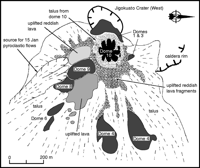 |
Figure 48. Sketch map of the lava-dome complex on 5 February 1993. Note that north is to the right. Courtesy of Setsuya Nakada. |
The frequency of seismically detected pyroclastic flows had declined since mid-November, with the exception of bursts on 20 December and 15 January, and remained low through early February. The flows are thought to be generated by partial collapse of the dome complex. The 20 December flow traveled 3.7 km from the source, the largest of 1992. The flow front was ~ 300 m beyond the point where 43 people were killed by a pyroclastic surge 3 June 1991. The source material for the 20 December pyroclastic flow is thought to be large lava blocks extruded about one month earlier. Field reports showed that the deposits tapered and thinned to the front. The block-and-ash-flow deposits were not accompanied by pyroclastic surge deposits. Lava blocks found in the pyroclastic flow were massive and dense. Geologists considered two alternative models for the source of the ash: 1) it originated at the source of the pyroclastic flow, or 2) it formed from the disintegration of collapsed lava blocks. The 15 January flow traveled SE, eroding talus and pyroclastic flow deposits. Only 35 pyroclastic flows were recorded in January, down from 86 in December and 255 in November. The flows moved mainly towards the SE into the Akamatsu Valley. Ash clouds from the flows rose ~ 0.5 km.
Small earthquakes beneath and within the dome complex continued to occur at high rates. A total of 3,147 occurred in January, down slightly from 3,558 in December. Seismicity around the volcano was low. Frequency of earthquakes and pyroclastic flows were unchanged from January through early February. The number of evacuees from Shimbara city and Fukae town was unchanged at 2,008.
Geological Summary. The massive Unzendake volcanic complex comprises much of the Shimabara Peninsula east of the city of Nagasaki. An E-W graben, 30-40 km long, extends across the peninsula. Three large stratovolcanoes with complex structures, Kinugasa on the north, Fugen-dake at the east-center, and Kusenbu on the south, form topographic highs on the broad peninsula. Fugendake and Mayuyama volcanoes in the east-central portion of the andesitic-to-dacitic volcanic complex have been active during the Holocene. The Mayuyama lava dome complex, located along the eastern coast west of Shimabara City, formed about 4000 years ago and was the source of a devastating 1792 CE debris avalanche and tsunami. Historical eruptive activity has been restricted to the summit and flanks of Fugendake. The latest activity during 1990-95 formed a lava dome at the summit, accompanied by pyroclastic flows that caused fatalities and damaged populated areas near Shimabara City.
Information Contacts: JMA; S. Nakada, Kyushu Univ.