Report on Spurr (United States) — February 1993
Bulletin of the Global Volcanism Network, vol. 18, no. 2 (February 1993)
Managing Editor: Edward Venzke.
Spurr (United States) Low seismic activity; level of concern reduced from Yellow to Green
Please cite this report as:
Global Volcanism Program, 1993. Report on Spurr (United States) (Venzke, E., ed.). Bulletin of the Global Volcanism Network, 18:2. Smithsonian Institution. https://doi.org/10.5479/si.GVP.BGVN199302-313040
Spurr
United States
61.299°N, 152.251°W; summit elev. 3374 m
All times are local (unless otherwise noted)
Because of continued low seismicity, on 5 March 1993 the Alaska Volcano Observatory downgraded its Level of Concern Color Code for Spurr from Yellow to Green. Seismicity has remained low since December 1992, longer than the quiet period between the 27 June and 18 August 1992 eruptions. Between 12 February and 12 March 1993 two or fewer events/day were recorded. Measurements on 18 February of CO2 (400 tons/day) and SO2 (none detected) were similar to those made in early January. Visual inspection of Crater Peak between 12 and 19 February showed no significant morphological changes to the crater area, although one large slab of glacial ice is detaching from the outer NE flank. It may produce a significant seismic signal if it fails suddenly.
Spurr was last at color code green from 8 July to 18 August 1992. Green indicates that the "volcano is in its normal 'dormant' state." The observatory did warn that "the possibility for steam and ash explosions still exists. Should such explosions occur, they are unlikely to pose a hazard to high-flying aircraft or to communities downwind."
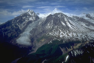
Geological Summary. Mount Spurr is the closest volcano to Anchorage, Alaska (130 km W) and just NE of Chakachamna Lake. The summit is a large lava dome at the center of a roughly 5-km-wide amphitheater open to the south formed by a late-Pleistocene or early Holocene debris avalanche and associated pyroclastic flows that destroyed an older edifice. The debris avalanche traveled more than 25 km SE, and the resulting deposit contains blocks as large as 100 m in diameter. Several ice-carved post-collapse cones or lava domes are present. The youngest vent, Crater Peak, formed at the southern end of the amphitheater and has been the source of about 40 identified Holocene tephra layers. Eruptions from Crater Peak in 1953 and 1992 deposited ash in Anchorage.
Information Contacts: AVO.

