Report on Kilauea (United States) — February 1993

Bulletin of the Global Volcanism Network, vol. 18, no. 2 (February 1993)
Managing Editor: Edward Venzke.
Kilauea (United States) Episode 53 begins; lava flows from tube breakout reach Kamoamoa delta
Please cite this report as:
Global Volcanism Program, 1993. Report on Kilauea (United States) (Venzke, E., ed.). Bulletin of the Global Volcanism Network, 18:2. Smithsonian Institution. https://doi.org/10.5479/si.GVP.BGVN199302-332010
Kilauea
United States
19.421°N, 155.287°W; summit elev. 1222 m
All times are local (unless otherwise noted)
"An upper east rift intrusive swarm began at 2325 on 7 February. More than 5,000 microshocks were counted in the first 48 hours of the swarm; these continued, in smaller numbers, until 18 February, when counts gradually decreased to normal. Several hundred events were processed, most located near Makaopuhi Crater, ~15 km SE of the summit and 6.4 km SW of Pu'u ' O'o. High-amplitude tremor beneath the summit accompanied the swarm. The count of shallow, short-period events beneath the summit was low, while that of shallow, long-period events was slightly above average until 22 February, peaking at >100 events on 19 February. The Uwekahuna water-tube tiltmeter at the summit of Kīlauea recorded ~15 µrad of deflation during the swarm. The tilt then reversed, recovering all of the deflation associated with the swarm by 23 February. The summit then slowly deflated again, with an E tilt of ~4 µrad recorded 23 February-1 March.
"On 8 February the magma supply to the E-51 vent was interrupted. Eruption tremor amplitudes, which had been ~2x background, rapidly diminished to background by 0400. As the E-51 tube system drained at the coast, sea water entered the tube, resulting in increased explosive activity starting at 0430 that continued intermittently for 3 hours. All flows stagnated by 9 February, but skylights remained incandescent for several days.
"The floor of Pu`u `O`o crater (35 m below the rim) collapsed on 8 February. After the collapse, the bottom of the crater consisted of talus slopes, with the lowest point >85 m below the crater rim. The lava pond reappeared on 10 February, and flows began to resurface the crater floor.
Episode 53 (E-53). "Eruption tremor remained at background levels until a gradual increase in amplitude on 16 February. On the same day, the lava pond in Pu`u `O`o rose dramatically and slow-moving lava was visible through the upper skylights of the E-51 tube. Two days later, sluggish pahoehoe flows broke out of the tube at 640 m elevation. More flows broke out at lower elevations, and by 20 February, channelized flows reached the top of Pulama pali. At 1450, lava fountains up to 4 m high were observed on the S flank of Pu`u `O`o, marking the beginning of E-53. The following day, the E-53 vent was ejecting spatter 15 m into the air and had formed a 30 m wide cone, with walls as high as 14 m. Flows from the vent area fanned out, filling the old E-52 collapsed pond and heading S towards the E-51 tube system.
"On 22 February, E-53 flows entered the E-51 tube through a skylight at 715 m elevation. The increase in magma in the tube led to an increase in activity. From 0000 to 0500, the eruption tremor amplitude increased noticeably to ~3-4x background. Amplitudes were sustained at 2-3x background for the remainder of the week. Large channelized flows advanced down the pali, fed by both the E-51 and E-53 vents. These flows merged with breakouts between 150 and 120 m elevation, reaching 60 m on 26 February. By 1 March, lava flows from the two vents were within 200 m of the ocean on the Kamoamoa delta, and within 40 m of Chain of Craters Road (figure 88).
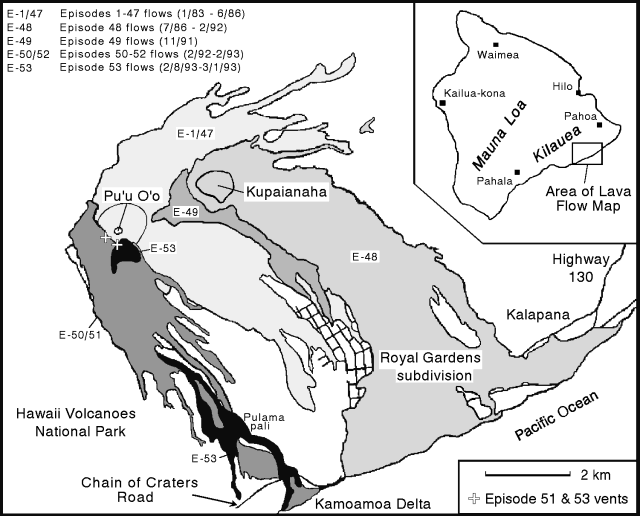 |
Figure 88. Map of recent lava flows from the East rift zone of Kīlauea, April 1993. Courtesy of HVO. |
"On 26 February, the crater floor in Pu`u `O`o was 59 m below the spillway rim. The last 2 weeks in February, lava in the pond fluctuated between this level and ~77 m below the rim."
Geological Summary. Kilauea overlaps the E flank of the massive Mauna Loa shield volcano in the island of Hawaii. Eruptions are prominent in Polynesian legends; written documentation since 1820 records frequent summit and flank lava flow eruptions interspersed with periods of long-term lava lake activity at Halemaumau crater in the summit caldera until 1924. The 3 x 5 km caldera was formed in several stages about 1,500 years ago and during the 18th century; eruptions have also originated from the lengthy East and Southwest rift zones, which extend to the ocean in both directions. About 90% of the surface of the basaltic shield volcano is formed of lava flows less than about 1,100 years old; 70% of the surface is younger than 600 years. The long-term eruption from the East rift zone between 1983 and 2018 produced lava flows covering more than 100 km2, destroyed hundreds of houses, and added new coastline.
Information Contacts: T. Mattox and P. Okubo, HVO.