Report on Rabaul (Papua New Guinea) — March 1993

Bulletin of the Global Volcanism Network, vol. 18, no. 3 (March 1993)
Managing Editor: Edward Venzke.
Rabaul (Papua New Guinea) Seismic activity increases; no significant surface deformation
Please cite this report as:
Global Volcanism Program, 1993. Report on Rabaul (Papua New Guinea) (Venzke, E., ed.). Bulletin of the Global Volcanism Network, 18:3. Smithsonian Institution. https://doi.org/10.5479/si.GVP.BGVN199303-252140
Rabaul
Papua New Guinea
4.2459°S, 152.1937°E; summit elev. 688 m
All times are local (unless otherwise noted)
"There was a marked increase in seismic activity in March; 1,685 earthquakes were recorded . . . . This is the highest monthly total since April 1986 (1,769 earthquakes), and the second highest since the 1983-85 crisis period.
The earthquakes occurred both individually and in swarms. Large swarms, with >100 events, occurred 9, 15, 18, and 30 March. Only a few of the earthquakes were felt, the largest on the 15th, M 3.0-3.5. All of the 35 accurately located earthquakes were on the ring-fault system, and the majority were clustered near the recent eruptive centres of Vulcan (9) and Tavurvur/Rabalanakaia (16) (figure 12). Most of the events were located at depths <2 km. Nearly all of the Vulcan earthquakes occurred before 4 March, though the Tavurvur/Rabalanakaia events occurred throughout the month. Routine monthly leveling on the 23rd showed no significant changes from previous months. Wet and dry tilt measurements also showed no trends."
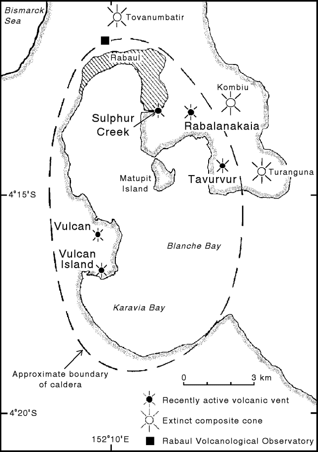 |
Figure 12. Map of the Rabaul Caldera showing recently active volcanic vents and extinct composite cones (modified from Almond and McKee, 1982). |
Reference. Almond, R. A., and McKee, C. O., 1982, Location of volcano-tectonic earthquakes within the Rabaul Caldera: Geological Survey of Papua New Guinea Report 82/19.
Geological Summary. The low-lying Rabaul caldera on the tip of the Gazelle Peninsula at the NE end of New Britain forms a broad sheltered harbor utilized by what was the island's largest city prior to a major eruption in 1994. The outer flanks of the asymmetrical shield volcano are formed by thick pyroclastic-flow deposits. The 8 x 14 km caldera is widely breached on the east, where its floor is flooded by Blanche Bay and was formed about 1,400 years ago. An earlier caldera-forming eruption about 7,100 years ago is thought to have originated from Tavui caldera, offshore to the north. Three small stratovolcanoes lie outside the N and NE caldera rims. Post-caldera eruptions built basaltic-to-dacitic pyroclastic cones on the caldera floor near the NE and W caldera walls. Several of these, including Vulcan cone, which was formed during a large eruption in 1878, have produced major explosive activity during historical time. A powerful explosive eruption in 1994 occurred simultaneously from Vulcan and Tavurvur volcanoes and forced the temporary abandonment of Rabaul city.
Information Contacts: H. Patia, R. Stewart, and C. McKee, RVO.