Report on Unzendake (Japan) — March 1993

Bulletin of the Global Volcanism Network, vol. 18, no. 3 (March 1993)
Managing Editor: Edward Venzke.
Unzendake (Japan) Dome 11 extruded; endogenous dome growth deforms old crater rim
Please cite this report as:
Global Volcanism Program, 1993. Report on Unzendake (Japan) (Venzke, E., ed.). Bulletin of the Global Volcanism Network, 18:3. Smithsonian Institution. https://doi.org/10.5479/si.GVP.BGVN199303-282100
Unzendake
Japan
32.761°N, 130.299°E; summit elev. 1483 m
All times are local (unless otherwise noted)
Dome 10 continued exogenous growth on the top of the dome complex until mid-March when its NE half began collapsing, generating relatively large pyroclastic flows that traveled 4 km E into Kitakamikoba, an evacuated area, (9 March) and 3.5 km E (12 and 16 March). A 17 March overflight revealed a new lava dome, number 11, growing on the resulting collapse-cliff on the E slope of dome 10 (figure 52). From late March through early April, endogenous growth of the dome complex and exogenous growth of dome 11 occurred simultaneously. Despite frequent collapses, dome 11 was 200 m long, 150 m wide, and 70 m thick by mid-April, and dome 10 reached 1,440 m elevation, 80 m above Mt. Fugen, Unzen's previous summit peak. The endogenous growth resulted in cracks radiating out from the epicentral location of the magma supply vent on dome 10. The estimated magma supply rate increased . . . to 1-3 x 10⁵ m3/day during mid-March to mid-April.
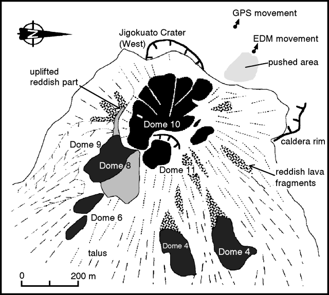 |
Figure 52. Sketch map of Unzen lava-dome complex on 2 April 1993. Note that N is to the right. Dome 11 began growing on a collapse-cliff of dome 10. EDM and GPS stations on the old crater wall NW of the dome complex (upper right) have moved as much as 2 m NW as a result of endogenous dome growth. Courtesy of S. Nakada. |
A portion of the NW crater wall was moved out from the dome complex as a result of the endogenous growth (figures 52 and 53). EDM measurements by the GSJ and GPS measurements by SEVO showed up to 2 m of NW movement at a point roughly 150 m NW of the dome complex. The affected area of the crater wall had many small, steaming cracks trending towards dome 10, and small-scale pressure ridges had formed on its surface near the dome complex.
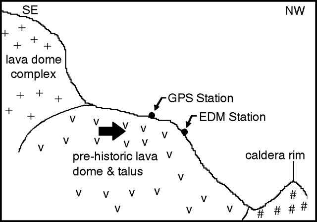 |
Figure 53. Cartoon representing a SE-NW cross-section of the "pushed area" on the NW side of the dome complex at Unzen. Endogenous growth of the lava-dome complex has pushed out the prehistoric lava dome and talus that formed a portion of the old crater rim (indicated by the large arrow). Courtesy of Setsuya Nakada. |
The frequency of pyroclastic flows generated by partial dome collapses gradually increased from 1 to 10/day in the first half of March. The frequency of flows had been low since mid-November, the longest lull of the current eruption (figure 54). The total of seismically recorded flows in March was 171, 4x that recorded in February. Collapses from domes 10 and 11 in late March to mid-April resulted in pyroclastic flows that typically traveled 1-3 km E and NE. The rate of pyroclastic flows remained at ~ 10/day.
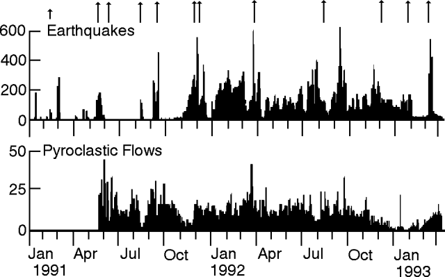 |
Figure 54. Daily count of earthquakes (top) and pyroclastic flows (bottom) at Unzen, 1 January 1991 to 15 April 1993. The 11 longer arrows at the top mark the onset of each of the domes; the short arrow indicates a phreatic eruption. Courtesy of JMA. |
The low seismicity of the dome complex since early February continued until an earthquake swarm slowly developed on 9 March (figure 54). After reaching a peak of 492 events on 14 March, activity declined to background by 17 March. The number of recorded earthquakes rose . . . to 2,985 in March.
As in previous months, a steam plume, occasionally containing ash, continued to rise a few hundred meters above the dome complex.
Geological Summary. The massive Unzendake volcanic complex comprises much of the Shimabara Peninsula east of the city of Nagasaki. An E-W graben, 30-40 km long, extends across the peninsula. Three large stratovolcanoes with complex structures, Kinugasa on the north, Fugen-dake at the east-center, and Kusenbu on the south, form topographic highs on the broad peninsula. Fugendake and Mayuyama volcanoes in the east-central portion of the andesitic-to-dacitic volcanic complex have been active during the Holocene. The Mayuyama lava dome complex, located along the eastern coast west of Shimabara City, formed about 4000 years ago and was the source of a devastating 1792 CE debris avalanche and tsunami. Historical eruptive activity has been restricted to the summit and flanks of Fugendake. The latest activity during 1990-95 formed a lava dome at the summit, accompanied by pyroclastic flows that caused fatalities and damaged populated areas near Shimabara City.
Information Contacts: JMA; S. Nakada, Kyushu Univ.