Report on Concepcion (Nicaragua) — March 1993
Bulletin of the Global Volcanism Network, vol. 18, no. 3 (March 1993)
Managing Editor: Edward Venzke.
Concepcion (Nicaragua) Detailed description of crater
Please cite this report as:
Global Volcanism Program, 1993. Report on Concepcion (Nicaragua) (Venzke, E., ed.). Bulletin of the Global Volcanism Network, 18:3. Smithsonian Institution. https://doi.org/10.5479/si.GVP.BGVN199303-344120
Concepcion
Nicaragua
11.538°N, 85.622°W; summit elev. 1700 m
All times are local (unless otherwise noted)
"On 10 January geologists climbed Concepción in unusually clear conditions, allowing a survey of the summit crater (figure 2). The crater is almost circular, 300 m in diameter and about 250 m deep. The upper part has a funnel shape, which descends into a pit crater. The N and E sides have a break in slope half way down; the SW side is a vertical cliff. This cliff is the head scarp of a landslide that fell into the crater in December 1992, forming a 100-m-wide scree slope infilling part of the pit crater. A 30-m-wide elliptical area plastered with yellow sulfur and containing two small sulfur mounds is at the lowest point.
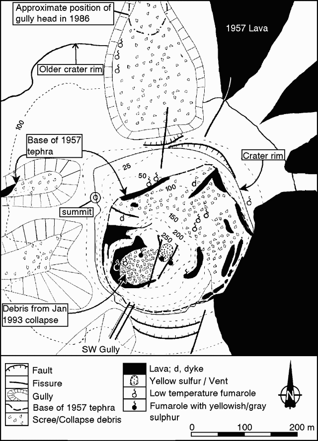 |
Figure 2. Map of the crater area of Concepción volcano made from observations 10 January 1993. Contours are approximate and represent height below the summit (about 1,700 m above sea level). The white area within the older crater rim contains pyroclastic deposits. Courtesy of B. van Wyk de Vries. |
"The summit morphology and crater shape have changed considerably since the pre-1957 eruption topographic map, which shows a broad 600-m-wide summit plateau with a 200-m-diameter crater. Now the summit is marked by a steep cone with a slope of 30-40°, and a knife-edged crater rim. Altered red lava below 1957 pyroclastics in the deep gullies to the W probably represent the pre-1957 surface and indicate that the present summit is 50-100 m higher than the spot height of 1,610 m surveyed before the 1957 eruption. If this interpretation is correct, Concepción could be the highest volcano in Nicaragua.
"Lava flows exposed in the crater walls and on the W flank are associated with copious semi-welded and welded pyroclastics and breccia. A prominent thick dyke on the NE side of the crater has the same strike as one of the historical lava flows, which it appears to have fed. Fractures running at 20°N cut the crater bottom near the sulfur mounds and on the N and SW walls. The strike is similar to fractures observed on the SW flank of the volcano, which are responsible for the formation of the deep SW gully. Other fractures in the crater are N-oriented (figure 2), some extending as far as the N flank of the cone, where they have fumarolic activity. These fumaroles are visible from the base of the volcano and have been periodically observed since 1986. Fumarolic areas with yellow-grey sulfur are also found around the crater walls. The most active fumaroles, however, are at the base of the pit crater, either on the sulfur mounds or along the 20°N-oriented fissures. Two moderate fumarolic areas with yellow-gray sulfur are on the S and W walls. No glow was observed from the crater rim, suggesting that no large high-temperature fumaroles were present.
"A local fireman reported ashfall on Alta Gracia (about 5.5 km NE of the summit) in December 1992, and a plume was reported during the same month. These phenomena were probably caused by the crater landslide. Vegetation, almost exclusively 'Sombrilla del Pobre' (Nostoc Gunnera) has begun to re-colonize the upper 200 m of the cone, which was bare in 1990, thus gas and ash emissions have been considerably lower than in the 1980's. However, analyses by Warren Spring Laboratory, UK, of SO2 diffusion tubes placed in the garden of a house in Esquipulas, 8 km E of the volcano, recorded an average SO2 concentration of 60 g/m3, indicating that gas emissions from the crater were sufficient to cause mild fumigation of populated areas downwind.
"Lahars continue to form during rainstorms, with the main loci of activity being the SW gully and the N flank. The road N of the volcano was cut by a lahar in late 1992. Erosion remains rapid on higher slopes, where some gullies had widened by 2-5 m since 1990. The 1957/74 pyroclastic deposits are especially vulnerable to erosion and gully headwalls have almost intersected the crater rim to the N, W, and SW in the last two years. Rapid erosion of these deposits probably constitutes much of the source for the laharic material to the N and W of the cone. The towns of San Jose del Sur (6.2 km SSW), San Marcos (5.6 km NNW), and La Flor (5.3 km NW) are in a particularly dangerous situation because they are in the paths of lahars descending these gullies. The fracture system in the crater walls could be a potential conduit for a future lava eruption that would flow toward the town of San Jose del Sur."
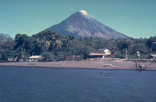
Geological Summary. Volcán Concepción is one of Nicaragua's highest and most active volcanoes. The symmetrical basaltic-to-dacitic stratovolcano forms the NW half of the dumbbell-shaped island of Ometepe in Lake Nicaragua and is connected to neighboring Madera volcano by a narrow isthmus. A steep-walled summit crater is 250 m deep and has a higher western rim. N-S-trending fractures on the flanks have produced chains of spatter cones, cinder cones, lava domes, and maars located on the NW, NE, SE, and southern sides extending in some cases down to Lake Nicaragua. Concepción was constructed above a basement of lake sediments, and the modern cone grew above a largely buried caldera, a small remnant of which forms a break in slope about halfway up the N flank. Frequent explosive eruptions during the past half century have increased the height of the summit significantly above that shown on current topographic maps and have kept the upper part of the volcano unvegetated.
Information Contacts: Andrea Borgia, Instituto Nazionale di Geofisica, via di Vigna Murata 605, 00143 Roma, Italy; B. van Wyk de Vries, Open Univ; Peter J. Baxter, Dept of Community Medicine, Fenner's, Gresham Road, Cambridge, England.