Report on Deception Island (Antarctica) — March 1993
Bulletin of the Global Volcanism Network, vol. 18, no. 3 (March 1993)
Managing Editor: Edward Venzke.
Deception Island (Antarctica) Activity declines from last year's levels
Please cite this report as:
Global Volcanism Program, 1993. Report on Deception Island (Antarctica) (Venzke, E., ed.). Bulletin of the Global Volcanism Network, 18:3. Smithsonian Institution. https://doi.org/10.5479/si.GVP.BGVN199303-390030
Deception Island
Antarctica
62.9567°S, 60.6367°W; summit elev. 602 m
All times are local (unless otherwise noted)
Activity has declined from the more vigorous behavior seen during the 1991-92 survey to levels recorded during earlier surveys. Only 135 seismic events (M 0.3-0.9) were recorded compared to the 766 events detected during the 1991-92 survey. Episodes of tremor in the NW sector of the island were recorded on 1 January, 2 February, and 16 February 1993. Five deep (55-85 km) earthquakes, M 1.6-2.4, were detected.
Fumaroles emitted mainly CO2 (87-98%) and H2S (1.8-13%); no SO2 was detected. Dry-tilt measurements of 600 µrads uplift at Fumarole Bay indicated a slight elevation of the entire fumarolic area. Temperature measurements made by the Spanish Oceanographic Ship "Hespérides" showed a decrease in the intensity of the submarine emissions in Port Foster Bay since the 1990-91 survey.
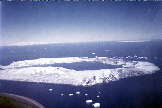
Geological Summary. Ring-shaped Deception Island, at the SW end of the South Shetland Islands, NE of Graham Land Peninsula, was constructed along the axis of the Bransfield Rift spreading center. A narrow passageway named Neptunes Bellows provides an entrance to a natural harbor within the 8.5 x 10 km caldera that was utilized as an Antarctic whaling station. Numerous vents along ring fractures circling the low 14-km-wide island have been reported active for more than 200 years. Maars line the shores of 190-m-deep Port Foster caldera bay. Among the largest of these maars is 1-km-wide Whalers Bay, at the entrance to the harbor. Eruptions during the past 8,700 years have been dated from ash layers in lake sediments on the Antarctic Peninsula and neighboring islands.
Information Contacts: R. Ortiz, Museo Nacional de Ciencias Naturales, Spain; C. Risso, Instituto Antártico Argentino.