Report on Lascar (Chile) — April 1993

Bulletin of the Global Volcanism Network, vol. 18, no. 4 (April 1993)
Managing Editor: Edward Venzke.
Lascar (Chile) Eruption sends ash above 25 km altitude; pyroclastic flows travel 7.5 km
Please cite this report as:
Global Volcanism Program, 1993. Report on Lascar (Chile) (Venzke, E., ed.). Bulletin of the Global Volcanism Network, 18:4. Smithsonian Institution. https://doi.org/10.5479/si.GVP.BGVN199304-355100
Lascar
Chile
23.37°S, 67.73°W; summit elev. 5592 m
All times are local (unless otherwise noted)
The largest historical eruption of Lascar began late on 18 April and sent ash 20-22 km above the . . . crater rim the following day. Pyroclastic flows traveled 7.5 km NW and light ashfall (<0.1 mm) was reported in Buenos Aires, Argentina, 1,500 km SE of the volcano.
A survey conducted from January to 14 March revealed that fumarolic activity persisted with columns sometimes absent but other times rising 500-1,000 m above the crater rim. A decrease in fumarolic activity 3-8 March preceded a small phreatomagmatic eruption on 10 March that produced a column 2,000 m high (Gardeweg and others, 1993). Similar activity had also been noted on 30 January when a higher eruption column followed a few days of low level activity. During 10-14 March, the column height remained at 500-1,000 m. Observations from 14 March to the evening of 20 April were made by Ibar Torrejón, a teacher in Talabre (17 km WNW) who maintains a log of Lascar's activity. From 8-17 April the column was also low: 100-200 m. The only other observed pre-eruption change was in the color of the column, from yellowish gray (8-11 April) to whitish pale-blue (12-17 April).
Eruptive activity. Activity on 18 April was primarily phreatic until 2200 when a large explosion threw incandescent material into the air. An explosion at 2300 produced a Plinian column. These initial explosions may have been related to the partial destruction of the dome that had filled the crater in March 1992 (17:3 and 5) and collapsed sometime between 12 November and 7 December.
At 0700 on 19 April, a low, dark, ash-laden Plinian column was observed, which slowly rose 5-10 km above the rim by 0900. (Initial reports of column heights were systematically high; corrected estimates are given here). Bombs were observed throughout the morning. At 1012 the column rose above 10 km, and the first pyroclastic flow down the N flank was seen: flows also descended the NE and SE flanks, but were not observed. Other large columns (10-15 km) accompanied by pyroclastic flows were recorded at 1030, 1205, and 1317. A witness in La Escondida mine (175 km SW) described these columns as much larger than those from the 1990 eruption (15:2). The explosion at 1317 produced a column that rose 20-22 km above the rim: it was accompanied by strong rumbling and ejection of bombs to heights > 2 km. The column dropped to 2 km height until an explosion at 1715 sent it back above 15 km. Nearly 30 minutes of continuous pyroclastic flow activity near the summit began at 1935. Large explosions at 2135-2148 and 2340-2350 preceded pyroclastic flows down the N and NW slopes. Ash was blown predominately ESE.
Activity declined until 0340 on 20 April when new Strombolian explosions began, ejecting incandescent spatter up to 1.5 km above the rim. Major explosive activity resumed at 0628, producing a column >10 km high and ejecting blocks to heights >1 km. The next large explosion, at 0920, was accompanied by strong rumbles and underground noises. It generated a column nearly 10 km high and its collapse produced the farthest-reaching pyroclastic flows (7.5 km NW). Seen from Sierra Gorda (165 km WNW), the column had a well-formed mushroom shape. It remained 2-4 km high until another large explosion at 1302, which sent the column to 8.5 km within 8 minutes before it began to drift NE. One observer reported two columns rising from the crater during this explosion, the W one a darker gray-brown. At 1500 the height of the yellow-gray column decreased to 3.5-4 km, and persisted at this height until 1915 when nightfall prevented further observations. During the night, no eruptions were recorded, and no incandescent material was seen above the crater or on the flanks of the volcano.
Observations at 0630 the following morning indicated that Lascar had returned to its normal fumarolic activity with weak columns that hardly rose above the crater rim. Small explosions on 22, 23, 26, and 29 April produced columns 1000 m above the rim, but the column otherwise remained low (100-300 m) and white with occasional ash explosions to 500-800 m high. This activity continued through 8 May. During this period 2 discrete fumarolic gas columns were again observed rising from the NE and W sides of the crater, suggesting changes in its morphology from March, when only one column was noted.
An overflight of the volcano on 26 April by the National Emergency Office of the Chilean Air Force provided aerial photography of the crater and surrounding area at scales of 1:33,000 and 1:3,500. From these photographs, a new lava dome was identified in the bottom of the crater, filling a much larger portion of the crater than either the 1989 or 1992 domes. The exposed base of the dome was ~60 m higher than the previous dome and 100 m above the known crater floor (5,145-m elev). A preliminary volume estimate of the new dome was 4.6 x 10⁶ m3. The dome appeared as a flat surface with concentric cooling ridges and steep walls devoid of a talus apron. Fumarolic activity was restricted to the margins of the dome, primarily on the SE edge. Fresh tephra partially covered the walls of the active crater, particularly in the benches, and filled the E craters (figure 13). The crater showed no other remarkable morphological changes.
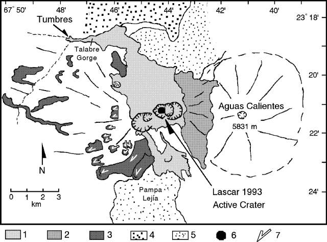 |
Figure 13. Sketch map of the distribution of pyroclastic flows from the 19-20 April eruption of Lascar, based on photos taken on 26 April. Featured are (1) 19-20 April pumiceous pyroclastic-flow deposits, (2) 19-20 April undifferentiated pyroclastic material, (3) Previous lava flows partially covered by pyroclastic-flow deposits, (4) Pliocene welded ignimbrites, (5) Miocene to Pliocene domes, (6) the new lava dome, and (7) arrows indicating lava flows. Courtesy of M. Gardeweg, SERNAGEOMIN. |
Five portable seismographs were installed around the volcano on the evening of 20 April. Preliminary analysis showed that the harmonic tremor recorded January-March 1993 was not initially present, but returned a couple of days after the eruption. A small number of high-frequency events occurred 21-25 April. A swarm of B-type events on 28 April may have been associated with the new dome formation, and an increase in activity on 30 April may have marked the injection of new magma.
Eruption products. M. Gardeweg characterized the eruption products as pyroclastic flows, co-ignimbrite fallout (pumice and ash) deposited mainly to the E, and projectiles (figure 13). The pyroclastic flows were small-volume ignimbrites composed of abundant rounded andesitic pumice in a gray ash matrix. Most flows traveled ~4 km from the crater, but some to the NW were channeled by the upper Talabre gorge and reached Tumbres, a swampy ground 7.5 km from the crater where springs supply water for the village of Talabre. The flow deposit was covered by a narrow, thin veneer of very fine-grained ash, which was constantly blown by the wind. Degassing pipes were observed in the Tumbres deposit. A day after the eruption, the flow front was still warm, but was cooling rapidly.
The water supply to Talabre was cut off by the pyroclastic flow, but a few hours after its emplacement, water eroded through the pyroclastic material, and developed a new creek in the gorge. Donkeys and small insects were back in Tumbres the day after the eruption. The water contained a large amount of ash, but its pH was 7.6-7.7, only slightly less than its normal 8.3. Grass samples from Tumbres that were covered by ash showed 33% more fluorine than samples of clean grass. Ash from Chilean volcanoes Hudson and Lonquimay also contained notable amounts of fluorine.
The lapilli varied from white and vesicular pumices to a denser scoriae. Banding evident in some lapilli mainly reflects different degrees of vesicularity. A few dense blocks (2(black scoriae) to 60.4% SiO2 (white pumices). The fine ash has a similar andesitic composition (60.3% SiO2) with slight K enrichment. Large blocks (>2 m) left 4-5 m diameter impact craters up to 7 km from the crater. In Lejía, 17 km SSE of the volcano, a thin cover of pumice fragments 6-9 cm in diameter was noted. Huaitiquina Pass, 65 km SE on the Chilean-Argentine border, received only a thin layer of fine ash (4-4.5 mm), largely blown by wind and concentrated below cliffs or in depressions. No fall-out was found in El Laco, 55 km SE (slightly S of Huaitiquina).
The eruption also affected Argentina and J. Viramonte provided the following information. The total volume of erupted material (excluding material injected into the stratosphere) was estimated to be 0.1 km3: 0.09 km3 proximal air fall, 0.0085 km3 distal air fall, and 0.0037 km3 pyroclastic flow.
Viramonte noted that pyroclastic-flow deposits W of the crater, 7.5 km long and 1.5-2 m thick, cut the road between Antofagasta, Chile, and Salta, Argentina. He described the deposits as 60% coarse juvenile andesitic pumice fragments (2-60 cm in diameter) mixed with a minor volume of dense andesitic blocks as large as 1 m in diameter (from the old summit lava dome), and 40% fine-grained andesitic material. A very fine-grained ash-cloud-surge deposit, 5-30 cm thick, that clearly burned vegetation, flanked the pyroclastic-flow deposits. On 23 April temperatures of the deposits were as high as 100°C. These units may have been emplaced during the continuous emission of pyroclastic flows that began at 1935 on 19 April.
Four superposed pyroclastic-flow units begin 3 km from the crater rim on the ESE flank of the volcano, and extend 3-4 km to the Pampa Lejía plain. They are 1.2-1.5 m thick and composed of mainly white juvenile pumice fragments and gray blocks from the lava dome (70-80%), and fine-grained material (20-30%). Many light-and-dark banded pumice fragments were present.
Three short pyroclastic-flow lobes on the E side of the volcano had been covered by air-fall pumice. Many fumaroles with white ammonium chloride crystals and red yellow iron chloride crystals were present on the flows. Fumarole temperatures were as high as 250°C. At the foot of the pyroclastic-flow deposits, a thin ground-surge deposit was identified 100-150 m up the side of Corona hill at the S end of Lascar.
Ejected bombs and blocks were abundant within a 3-3.5 km radius of the crater, becoming rare 4 km distant. The ballistic clasts were pumiceous black andesitic bombs and dense gray andesitic blocks from the lava dome. Rounded and strongly vesiculated bombs as large as 70 cm in diameter were found 3 km from the crater. The lava-dome blocks were irregular and often showed a bread-crust structure.
Tephra carried by strong high-altitude winds produced a large dispersion of airfall deposits to the ESE (figure 14). Wind speed and direction reported by the Servicio Metereorológico Nacional Argentina at different localities (table 2) are consistent with the evolution of the ash cloud as tracked by NOAA using weather satellites.
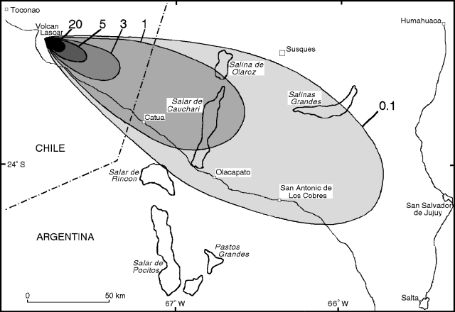 |
Figure 14. Isopach map of tephra fallout from April 19-20 eruption of Lascar. Depths are in cm. Closed fields indicate salars, saline playa lakes. Courtesy of J. Viramonte, Instituto Geonorte. |
Table 2. Wind speed and direction at selected cities (see figure 15) downwind of the 19-20 April eruption of Lascar. Data are from the Servicio Metereorológico Nacional Argentina. Courtesy of J. Viramonte, Instituto Geonorte.
| Date | Station | Altitude (km) | Direction (degrees) | Velocity (km/hour) |
| 19 Apr 1993 | Resistencia | 10.8 | 305 | 91 |
| 19 Apr 1993 | Resistencia | 12.3 | 270 | 41 |
| 19 Apr 1993 | Resistencia | 14.1 | 285 | 46 |
| 19 Apr 1993 | Resistencia | 16.5 | 275 | 41 |
| 19 Apr 1993 | Córdoba | 10.8 | 355 | 98 |
| 19 Apr 1993 | Córdoba | 12.3 | 345 | 59 |
| 19 Apr 1993 | Córdoba | 14.0 | 310 | 124 |
| 19 Apr 1993 | Córdoba | 16.4 | 300 | 56 |
| 19 Apr 1993 | Salta | 10.9 | 325 | 63 |
| 19 Apr 1993 | Salta | 12.3 | 310 | 91 |
| 19 Apr 1993 | Salta | 14.1 | 310 | 85 |
| 19 Apr 1993 | Salta | 16.5 | 295 | 91 |
| 20 Apr 1993 | Resistencia | 10.9 | 330 | 54 |
| 20 Apr 1993 | Resistencia | 12.4 | 320 | 72 |
| 20 Apr 1993 | Resistencia | 14.1 | 295 | 76 |
| 20 Apr 1993 | Resistencia | 16.6 | 290 | 65 |
| 20 Apr 1993 | Córdoba | 10.6 | 355 | 200 |
| 20 Apr 1993 | Córdoba | 12.1 | 355 | 202 |
| 20 Apr 1993 | Córdoba | 14.0 | 335 | 126 |
| 20 Apr 1993 | Córdoba | 16.4 | 300 | 115 |
| 20 Apr 1993 | Salta | 12.3 | 285 | 98 |
| 20 Apr 1993 | Salta | 14.1 | 285 | 83 |
| 20 Apr 1993 | Salta | 16.5 | 280 | 56 |
| 20 Apr 1993 | Salta | 18.6 | 260 | 44 |
The maximum diameter of air-fall clasts on the flanks of the volcano was 30-40 cm. The maximum tephra thickness was 0.6 m on the E side of Lascar where it intersects Aguas Calientes Volcano. Approximately 20,000 km2 received at least 1 mm of ash (figure 14), and over 850,000 km2, including parts of N-central Argentina, S Paraguay, Uruguay, and S Brazil, were covered by a thin (<0.1 mm) deposit of ash (figure 15).
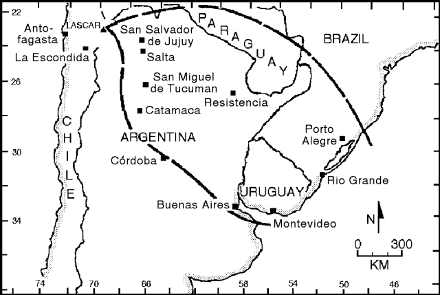 |
Figure 15. Approximate ash-fall distribution from the 18-20 April eruption of Lascar. The thick lines outline the area receiving ashfall according to news reports. Courtesy of M. Gardeweg, SERNAGEOMIN. |
Satellite monitoring. GOES-7 visible and infrared imagery detected five major eruption pulses starting at 2300 on 19 April (table 3). The plume was very dark in the visible imagery, similar to the appearance of the 14-15 June 1991 clouds from Mount Pinatubo. A subtropical jetstream moved the plume rapidly ESE (figure 16) at ~93 km/hour.
Table 3. Summary of explosive phases of Lascar detected on 20 April with visible and infrared satellite imagery from GOES-7 and NOAA-11. The tropopause was at 15.7-km altitude in the region at 1200 GMT. Courtesy of Jim Lynch, NOAA/NESDIS.
| Date | Approximate Eruption Start Time | Duration (hours) | Maximum Altitude (km) |
| 19 Apr 1993 | 2300 | 1.0 | 14-16 |
| 20 Apr 1993 | 0300 | 1.0 | 14-16 |
| 20 Apr 1993 | 0630 | 1.5 | 14-16 |
| 20 Apr 1993 | 0930 | 1.5 | 14-16 |
| 20 Apr 1993 | 1300 | 5.0 | 10-12 |
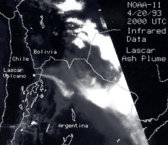 |
Figure 16. Image of the plume of Lascar, 1600 on 20 April. The image was processed from NOAA-11 Advanced Very High Resolution Radiometer (AVHRR) channel 4 (thermal infrared) data. Compare with figure 3. Courtesy of G. Stephens, NOAA. |
D. Rothery, C. Oppenheimer, and P. Francis noted the following changes in the active crater of Lascar using Landsat's TM. "We have been monitoring thermal events within Lascar's active crater for several years using the short wavelength infrared radiance of thermal origin. The latest image we have prior to the 20 April 1993 eruption was recorded by Landsat 5 on 24 February.
"Whereas our 1991 and 1992 data showed a strongly centered group of thermally radiant pixels that coincided with the lava dome (figure 17 bottom), there was a significant change visible on 24 February 1993 (figure 17 top). The central anomaly has decreased in size and magnitude, but there is a distinct subsidiary peak in thermal radiance to the E. This coincided with the position of a fumarole that had been more weakly radiant on previous images. This site lies about half-way down the wall of the active crater, which at this point is embedded in the floor of an old crater (see figure 13). We have no grounds for suggesting that this newly prominent site was the seat of the 19-20 April eruption. The nature of the central anomaly on 24 February, which had decreased to the approximate size and magnitude of the anomaly recorded from late 1987 until the end of 1989, suggests that the lava dome was still in existence on that date.
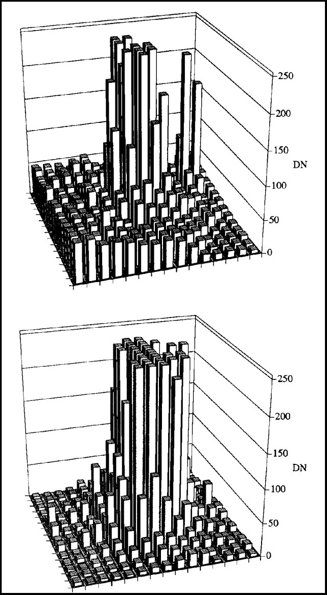 |
Figure 17. Radiance in Landsat TM band 7 (2.08-2.35 micron) for a 15x15 pixel area encompassing Lascar's active crater, looking N. Data are from 24 February 1993 during the day (top), and 15 April 1992 during the night (bottom) (from figure 21b in Oppenheimer and others, 1993). Each pixel represents a 30 x 30 m ground area. Radiance is shown as DN, which is the number recorded by the sensor. In this example, areas with DN of about 50 or less are not thermally radiant and the DN represents reflected sunlight. Where DN exceeds about 100, the surface is radiating thermally, and the DN represents the sum of reflected sunlight and thermal radiance. Courtesy of D. Rothery, Open Univ. |
"The summed spectral radiance of thermal origin in Landsat TM bands 5 and 7 showed a decline before the 1993 eruption similar to that before the September 1986 eruption (figure 18). There was no observed decline before the February 1990 eruption, though that could be the result of the lack of images before the eruption."
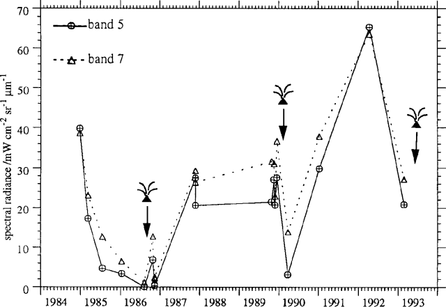 |
Figure 18. Summed spectral radiance of thermal origin in Landsat TM bands 5 and 7 for the active crater of Lascar (from figure 18 in Oppenheimer and others, 1993 with data for 24 February 1993 added). Eruptions are noted by arrows. The decline in summed radiance prior to the 1993 eruption is similar to that preceding the 1986 eruption. There was no observed decline before the February 1990 eruption, though that could be the result of the lack of images during 1988-89. Courtesy of D. Rothery, Open Univ. |
Effects and previous activity. The 70 [people] who live in Talabre and make their living as llama herders and weavers were evacuated [to the nearby village of Toconao for two nights] by authorities on 19 April. Initial reports indicated that there had been no injuries. However, many defied the order and returned to tend their homes and animals. As many as six people were listed as missing, having apparently gone searching for their animals on the SE side of the volcano. [The people listed as missing were forced to make a detour because their normal route was covered by pumice and ash, but they arrived safely 3 days after the eruption.]
References. Gardeweg, M.C., Sparks, S., Matthews, S., Fuentealba, G., Murillo, M, and Espinoza, A., 1993, V Informe sobre el comportamiento del Volcán Lascar (II Región): Enero Marzo 1993, Informe Inédito, Biblioteca Servicio Nacional de Geología y Minería, 14 p.
Oppenheimer, C., Francis, P.W., Rothery, D.A., Carlton, R.W.T., and Glaze, L.S., 1993, Infrared image analysis of volcanic thermal features: Lascar volcano, Chile, 1984-1992, Journal of Geophysical Research, v. 98, p. 4269-4286.
Geological Summary. Láscar is the most active volcano of the northern Chilean Andes. The andesitic-to-dacitic stratovolcano contains six overlapping summit craters. Prominent lava flows descend its NW flanks. An older, higher stratovolcano 5 km E, Volcán Aguas Calientes, displays a well-developed summit crater and a probable Holocene lava flow near its summit (de Silva and Francis, 1991). Láscar consists of two major edifices; activity began at the eastern volcano and then shifted to the western cone. The largest eruption took place about 26,500 years ago, and following the eruption of the Tumbres scoria flow about 9000 years ago, activity shifted back to the eastern edifice, where three overlapping craters were formed. Frequent small-to-moderate explosive eruptions have been recorded since the mid-19th century, along with periodic larger eruptions that produced ashfall hundreds of kilometers away. The largest historical eruption took place in 1993, producing pyroclastic flows to 8.5 km NW of the summit and ashfall in Buenos Aires.
Information Contacts: M. Gardeweg and A. Espinoza, SERNAGEOMIN, Santiago; E. Medina, Univ Católica del Norte, Antofagasta; M. Murillo, Univ de la Frontera, Temuca, Chile; J. Viramonte, R. Marini, R. Bocchio, and R. Pereyra, Univ Nacional de Salta, Instituto Geonorte - CONICET, Argentina; R. Seggiaro, M. Bosso, N. Monegatti, and M. Bolli, Univ Nacional de Salta, Instituto Geonorte, Argentina; R. Ortiz Ramis, CSIC, J. Gutierrez Abascal, Spain; I. Torrejón, Esccuela Básica G-29, Talabre, Chile; D. Rothery, C. Oppenheimer, and P. Francis, Open Univ; J. Lynch, SAB; G. Stephens, NOAA; American Embassy, Santiago, Chile.