Report on Kelimutu (Indonesia) — June 1993
Bulletin of the Global Volcanism Network, vol. 20, no. 6 (June 1993)
Managing Editor: Edward Venzke.
Kelimutu (Indonesia) Increased seismicity for three months
Please cite this report as:
Global Volcanism Program, 1993. Report on Kelimutu (Indonesia) (Venzke, E., ed.). Bulletin of the Global Volcanism Network, 20:6. Smithsonian Institution. https://doi.org/10.5479/si.GVP.BGVN199306-264140
Kelimutu
Indonesia
8.77°S, 121.82°E; summit elev. 1639 m
All times are local (unless otherwise noted)
[Seismicity rose during February-April 1993, with 318 deep and 196 shallow earthquakes, but declined in June (VSI, 1993a).] (originally in 20:06)
Reference. Volcanological Survey of Indonesia, 1993a, Kelimutu Volcano: Journal of Volcanic Activity in Indonesia, v. 1:1/2, p. 14.
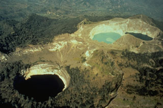
Geological Summary. Kelimutu is a small, but well-known, Indonesian compound volcano in central Flores Island with three summit crater lakes of varying colors. The western lake, Tiwi Ata Mbupu (Lake of Old People) is commonly blue. Tiwu Nua Muri Kooh Tai (Lake of Young Men and Maidens) and Tiwu Ata Polo (Bewitched, or Enchanted Lake), which share a common crater wall, are commonly colored green and red, respectively, although lake colors periodically vary. Active upwelling, probably fed by subaqueous fumaroles, occurs at the two eastern lakes. The scenic lakes are a popular tourist destination and have been the source of minor phreatic eruptions in historical time. The summit is elongated 2 km in a WNW-ESE direction; the older cones of Kelido (3 km N) and Kelibara (2 km S).
Information Contacts: VSI.