Report on Ol Doinyo Lengai (Tanzania) — July 1993

Bulletin of the Global Volcanism Network, vol. 18, no. 7 (July 1993)
Managing Editor: Edward Venzke.
Ol Doinyo Lengai (Tanzania) Increased carbonatite lava production; ash eruptions
Please cite this report as:
Global Volcanism Program, 1993. Report on Ol Doinyo Lengai (Tanzania) (Venzke, E., ed.). Bulletin of the Global Volcanism Network, 18:7. Smithsonian Institution. https://doi.org/10.5479/si.GVP.BGVN199307-222120
Ol Doinyo Lengai
Tanzania
2.764°S, 35.914°E; summit elev. 2962 m
All times are local (unless otherwise noted)
Activity since mid-June has perhaps been greater than at any other time during the current eruption . . . . Explosive eruptions have produced ash clouds visible from the surrounding region, and deposited some ash on the outer slopes of the cone. Lava fountaining within the crater has thrown volcanic bombs up to 10 cm long across the crater floor. New vents opened in the S part of the crater floor 8-29 June, where none had existed since detailed observations began in 1988. Carbonatitic lava extrusion down the outer, W slopes of the cone blocked the former climbing route.
Burra Gadiye (Sengo Safaris Ltd.) reached the W crater rim on 6 April. There was little change since late February, although T20 had clearly been the source of lava flows that reached the base of the W wall (figure 28). A loud explosion was heard at 0400 on 22 May at Karatu (70 km S) by Gadiye. An explosion near the summit at that time was later reported by residents of Ngare Sero (~10 km N).
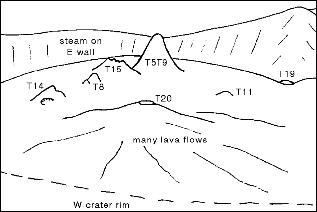 |
Figure 28. Panorama of Ol Doinyo Lengai crater looking E from the W rim, 6 April 1993. Drawn by C. Nyamweru from a photograph taken by Therese Berhault and Dominique Chevallier. |
By the time of an 8 June ascent by Gadiye, T20 had grown to the same approximate height as T5/T9, which was emitting steam. A new vent near the N wall (T21), the source of recent lava flows, had no liquid lava visible. There was also a new dome or low mound (T22) near the W wall (figure 29). A large amount of steam was being emitted from a crack between the two buttes near the W rim, between which the path led. An earthquake was reported on 14 June by Gadiye, and dark, dense plumes from the crater could be seen from Ngare Sero, causing local Maasai herdsmen to move their livestock. The next day, Gadiye and some visitors climbed a considerable distance up the W trail before being stopped by flowing lava that apparently originated between the two buttes. Gadiye was able to dip the end of his walking stick into the very liquid lava flow. Dark ash was being erupted from within the summit crater.
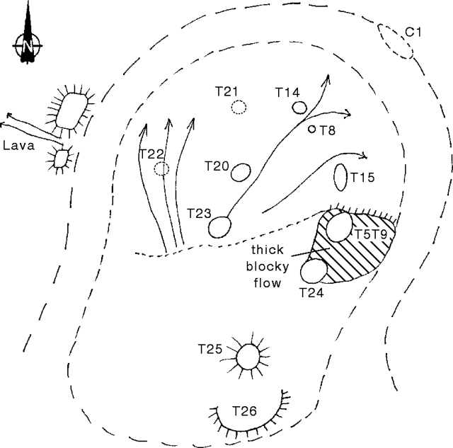 |
Figure 29. Sketch map of the crater of Ol Doinyo Lengai, 29 June 1993. Arrows on the crater floor indicate fresh lava flows. Drawn by C. Nyamweru from field sketches by C. Shrady and T. Peterson. Locations of T21 and T22 on 8 June are based on an interview with Burra Gadiye by Celia Nyamweru. |
Gadiye reported that ash fell on the W flank on 18 June, a black ash cloud rose from the summit at 1300-1500 on 21 June, and ash fell on local residents from 0800 to 1400 on 25 June after black ash clouds were blown E. A pilot who overflew the crater the week before 26 June (M. Bornir), reported that about half the crater was a bubbling black mass, two lava fountains were ejecting black material high into the air at short intervals, a new cone had formed, and smoke was abundant along the crater walls. Small light-colored plumes were seen from the surrounding area on the morning of 26 June, but when a group from St. Lawrence Univ arrived in mid-afternoon, they saw only a few small puffs of ash or steam from the summit at 1818-1821.
On 27 June, C. Nyamweru, C. Shrady, T. Coburn, and G. Cornwell (St. Lawrence Univ), Jumanne Juma (Dorobo Safaris Ltd.), and Danieli Kirway were unable to reach the crater rim from the W. No ash clouds were observed, but steam was seen at or near the W rim and a strong smell of sulfur was occasionally detected far down the outer slopes. A light dusting of fine gray ash on the outer slopes, increasing slightly in thickness towards the rim, covered leaves, spider webs, and small stones. Much of the vegetation near the summit was brown and dead. Steep rock slabs a few hundred meters below the rim were covered with several centimeters of loose ash, making climbing very difficult. The gap between the buttes had been blocked by a rockslide, apparently related to the 15 June lava flow. The dimensions of the lava flow were not measured, but the solid, cold surface was composed of broken slabs, some of which had pahoehoe structures.
Shrady, Coburn, and Cornwell, together with Thad Peterson and J. Juma, reached the E crater rim around 0830 on 29 June; they descended into the crater and remained until just after noon. Most of the crater floor (figure 29) was covered by dark, very fresh lava with both blocky and ropy textures. Much of it was still warm, and small pahoehoe flows were moving on the E half of the main crater floor. Lava flows were especially thick to the S, where the crater floor is now higher than cone T14 in the N. A large slab of the S crater wall near T24 had split from the rim and was standing free on the crater floor. Steam and sulfur fumes were escaping from several areas, particularly the E and N walls; only small amounts of steam were escaping along the W wall. The source of the 15 June lava flow was not determined.
Liquid lava was also erupting from a new vent (T23) just S of T20, with lava fragments being thrown 3-7 m above the rim of the vent at a rate of 4-8 bursts/min. The vent consisted of an outer, smooth, regular conical structure (white in color and higher on the W) surrounding smaller, black cones from which liquid lava was bursting. Activity continued throughout the morning, increasing in frequency and strength by noon, when clots of lava were being thrown 10 m high. The activity sounded like ocean surf, and there was a continuous dull rumble from below the vent. No lava flows issued from T23 that morning, but a very recent flow extended N from between T8 and T14. Lava flows from T23 have covered earlier flows NE of T20.
T20 had grown taller than T5/T9, previously the tallest feature, which was unchanged from February, although the top of the cone was steaming. The upper parts of T8 and T14 were visible, but had some sulfur staining and were surrounded by lava flows from other vents. T8 also exhibited some steam emission and occasional gas bursts. The E side of the T14 cone had collapsed, and was steaming weakly. Vent T24, wider than T20 but not as high, had a partly collapsed open top; its NW wall had collapsed, and it was the source of a large, 7-8 m thick flow of blocky lava (figure 29). On 29 June this flow was not moving, but fragments were falling down the flow front and its color was still dark. A sound similar to flowing water emerged from somewhere below T24. Vent T25, a circular fresh-looking black cone on the floor of the former 'Southern Depression,' was the source of a large flow of blocky lava that covered much of the S crater floor, though no liquid lava was present on 29 June. Feature T26 is a large black half-cone close to the base of the S crater wall, below the summit. Not active on the morning of 29 June, it might have been the source of volcanic bombs (up to 10 cm long) found on the crater floor and on the surface of fairly young lava flows, and possibly the source of some of the ash on the outer slopes. Vent T21 and dome T22, first seen on 8 June, were not observed.
On 3 July (1030-1100), Nyamweru and Shrady flew over the summit under clear conditions. No liquid lava could be seen bubbling in any of the vents or flowing on the crater floor, though much of the S and E parts of the crater were very black. Vegetation was brown on the inner crater walls and high on the outer slopes of the cone. Moderate amounts of steam were escaping from the W and N crater rim, from T20, and from the lower slopes of T5/T9. Sulfur odor could be detected from the aircraft. White ash covered much of the summit, extinct S crater, and the SE slopes, overlying the older gray ash.
Geological Summary. The symmetrical Ol Doinyo Lengai is the only volcano known to have erupted carbonatite tephras and lavas in historical time. The prominent stratovolcano, known to the Maasai as "The Mountain of God," rises abruptly above the broad plain south of Lake Natron in the Gregory Rift Valley. The cone-building stage ended about 15,000 years ago and was followed by periodic ejection of natrocarbonatitic and nephelinite tephra during the Holocene. Historical eruptions have consisted of smaller tephra ejections and emission of numerous natrocarbonatitic lava flows on the floor of the summit crater and occasionally down the upper flanks. The depth and morphology of the northern crater have changed dramatically during the course of historical eruptions, ranging from steep crater walls about 200 m deep in the mid-20th century to shallow platforms mostly filling the crater. Long-term lava effusion in the summit crater beginning in 1983 had by the turn of the century mostly filled the northern crater; by late 1998 lava had begun overflowing the crater rim.
Information Contacts: C. Nyamweru and C. Shrady, St. Lawrence Univ; Thad Peterson and J. Juma, Dorobo Safaris Ltd., Arusha; B. Gadiye, Sengo Safaris Ltd., Arusha; D. Kirway, Monduli, Tanzania; M. Bornir, Nairobi, Kenya; T. Berhault and D. Chevallier, France.