Report on Unzendake (Japan) — July 1993

Bulletin of the Global Volcanism Network, vol. 18, no. 7 (July 1993)
Managing Editor: Edward Venzke.
Unzendake (Japan) Exogenous dome growth continues; increased seismicity
Please cite this report as:
Global Volcanism Program, 1993. Report on Unzendake (Japan) (Venzke, E., ed.). Bulletin of the Global Volcanism Network, 18:7. Smithsonian Institution. https://doi.org/10.5479/si.GVP.BGVN199307-282100
Unzendake
Japan
32.761°N, 130.299°E; summit elev. 1483 m
All times are local (unless otherwise noted)
Exogenous growth at dome 11 . . . continued through early August (figure 57). Partial collapses generated about 10 pyroclastic flows/day to the E and NE, leaving a relatively stable part of dome 11 over the remnants of dome 4. No damage was caused by pyroclastic flows in July. Ash-laden plumes from the former Jigokuato crater, rising as high as 1 km, have frequently been observed since mid-July. Volcanic tremor at the summit area increased after 22 July, but no surface changes have been observed.
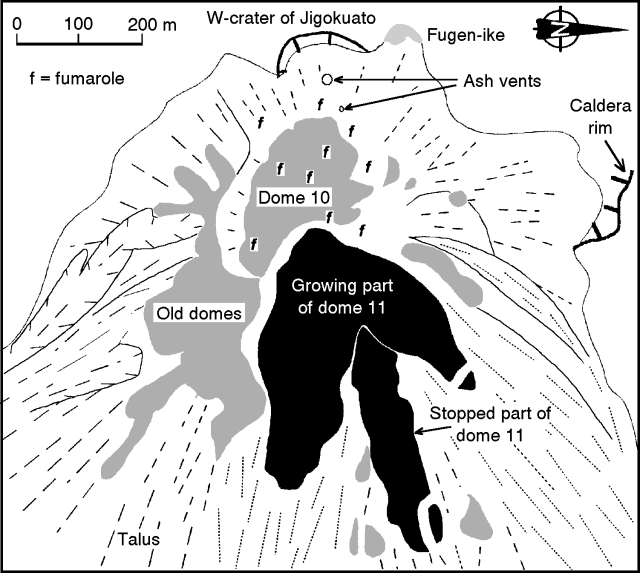 |
Figure 57. Sketch map of the lava dome complex at Unzen, early August 1993. Note that N is to the right. Courtesy of S. Nakada. |
During growth of dome 11, the E part was pushed outward and has collapsed frequently. A ramp structure formed, and lavas were successively overridden by later flows, like dominoes. The thickness of dome 11 decreased toward the front and lengthened, maintaining the ramp structure. This implies that stretching and sliding along the basal plane are the main reasons for the lengthening of the dome. The E arm of the dome was 400 m long, 150 m wide, and 50 m thick by the end of July, and had grown to 500 m in length by 7 August. Geologists estimated a growth rate of ~200,000 m3/day, with the eruption rate close to 250,000 m3/day.
On 19 July, 32 seismically recorded pyroclastic flows moved E along the Mizunashi Valley, the largest daily count in the month. The series began at 0354 and continued until midnight, including larger flows with seismic durations of 130 seconds at 0415 and 0428, 150 seconds at 0405 and 1131, and 170 seconds at 1700. The largest pyroclastic flow of the series occurred at 1821, with a duration of 190 seconds, and traveled 5.3 km E, crossing Route 57 (figure 58). The road was closed in late June after another pyroclastic flow crossed it. The front of the pyroclastic flow extended 100 m beyond the road, which is the farthest distance a pyroclastic flow has traveled from the active crater during the current period of activity. The longest pyroclastic flows, from W of dome 11, traveled 5.5 km on 8 June and 15 September 1991. There were a total of 353 seismically detected pyroclastic flows in July . . . . The number of evacuees from Shimabara and Fukae has remained unchanged at 3,617 since early July.
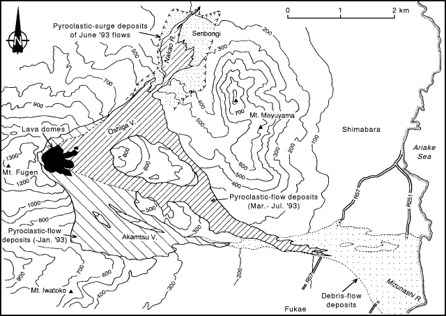 |
Figure 58. Map showing distribution of pyroclastic-flow and debris-flow deposits at Unzen from 1991 through early August 1993. Courtesy of S. Nakada. |
The frontal part of the 19 July pyroclastic-flow deposit was as narrow as a few tens of meters, and as long as 1 km (figure 58). Deposits were distributed along a narrow gully within older pyroclastic-flow and debris-flow deposits. A video taken of the 19 July pyroclastic flow showed that the front lobes of the growing ash cloud protruded intermittently from the main mass of the ash cloud for the last 1 km. Ground vibrations, usually recorded by seismometers during movement of block-and-ash flows, had stopped before this event. Deposits at the front of this flow were deficient in large lava blocks, which are common 2 km closer to the source, indicating that these may be a type of pyroclastic-surge deposit.
Seismicity at the lava dome complex was unchanged before and during the pyroclastic-flow activity. Low seismicity at the dome complex, about 20 events/day, was followed by a burst of activity that began on 26 July and culminated with 2,604 events on 7 August, the highest daily count in the present period of volcanism. The previous high was 632 on 11 September 1992. Seismicity gradually declined through 11 August, but remained high at about 800 events/day. Aerial inspections on 3, 5, and 8 August showed no unusual changes on the surface of the dome complex, which continued growing at a rate of 2-3 x 10⁵ m3/day. A total of 1,034 microearthquakes was recorded in July, more than double the total of 506 in June.
Heavy rainfall during the rainy season has frequently caused debris flows along the Nakao and Mizunashi rivers. Debris flows on 4-5 July damaged 25 houses, and another 83 houses were damaged on 16-18 July. Debris flows during the current activity have damaged 1,409 houses. During periods of heavy rainfall, mayors of Shimabara and Fukae issued temporary evacuation orders to 5,000-9,000 residents along the rivers.
Geological Summary. The massive Unzendake volcanic complex comprises much of the Shimabara Peninsula east of the city of Nagasaki. An E-W graben, 30-40 km long, extends across the peninsula. Three large stratovolcanoes with complex structures, Kinugasa on the north, Fugen-dake at the east-center, and Kusenbu on the south, form topographic highs on the broad peninsula. Fugendake and Mayuyama volcanoes in the east-central portion of the andesitic-to-dacitic volcanic complex have been active during the Holocene. The Mayuyama lava dome complex, located along the eastern coast west of Shimabara City, formed about 4000 years ago and was the source of a devastating 1792 CE debris avalanche and tsunami. Historical eruptive activity has been restricted to the summit and flanks of Fugendake. The latest activity during 1990-95 formed a lava dome at the summit, accompanied by pyroclastic flows that caused fatalities and damaged populated areas near Shimabara City.
Information Contacts: JMA; S. Nakada, Kyushu Univ.