Report on Unzendake (Japan) — August 1993

Bulletin of the Global Volcanism Network, vol. 18, no. 8 (August 1993)
Managing Editor: Edward Venzke.
Unzendake (Japan) Lobe 11 continues exogenous growth; increasing seismicity
Please cite this report as:
Global Volcanism Program, 1993. Report on Unzendake (Japan) (Venzke, E., ed.). Bulletin of the Global Volcanism Network, 18:8. Smithsonian Institution. https://doi.org/10.5479/si.GVP.BGVN199308-282100
Unzendake
Japan
32.761°N, 130.299°E; summit elev. 1483 m
All times are local (unless otherwise noted)
Starting with this report, terminology for lava domes at Unzen will be changed. The numbered "lava domes" will be called lobes, and the "lava dome complex" will be referred to as the lava dome.
Growth of the lava dome continued through early September. Lobe 11, which appeared in mid-March, grew to 640 m long, 200 m wide, and 50-100 m thick by the end of August, when it had an estimated volume of 6 x 10⁶ m3. This is the same approximate size reached before the large collapses in late June. Geologists estimate that the daily rate of dome growth was ~2-3 x 10⁵ m3, much higher than last December-January, but less than in 1991. The magma-supply vent, in the same location since March, now has ~100 m of lava above it, decreasing to several tens of meters to the E. As the lobe advanced, it covered the flanking talus slope formed by earlier collapse of the margins. By mid-September, the lobe had grown 100 m longer and 150 m wider, making it the largest lobe since May 1991. Older lobes reached a maximum length of ~400 m, which was surpassed by lobe 11 in June, when it attained 600 m in length. The growth pattern of lobe 11 is different than that observed for previous lobes. Growth of lobe 11 occurred as new slices of lava (several tens of meters thick) advanced over older slices. Movement of the frontal part (the lowest slice) was the slowest, while the newest, topmost slice moved the fastest. As a result of this pattern of growth, the slope at the front of the lobe became as steep as 45°. Each lava slice (20-30 m thick) consists of convex-downward layers as thin as several meters.
Partial collapses of lobe 11 generated about five pyroclastic flows/day to the E and NE, and have eroded both the sides and surface of the lobe. There were 134 seismically detected pyroclastic flows in August, compared to 353 in July (figure 59), none of which caused any damage. The longest flow of the month, detected at 1748 on 31 August, was caused by collapse of older lava blocks from dome 11 that had survived the June collapses. This pyroclastic flow was registered for 190 seconds on seismometers, and descended 3.5 km NE through the Oshiga Valley before entering the Mizunashi Valley and the Kita-kamikoba area; the ash cloud rose 2,500 m above the summit, the highest of the month. Since early March, several pyroclastic flows have followed the same route. Vents on the lava dome continuously emitted steam and ash to heights of 1 km (~2.5 km altitude), normal for the current eruption. Ash was present in about one-third of the emissions. Average cloud height from both pyroclastic flows and vent emissions has increased from earlier in the year (figure 60). The number of residents evacuated because of the threat of pyroclastic flows remained at 3,617, unchanged since early July.
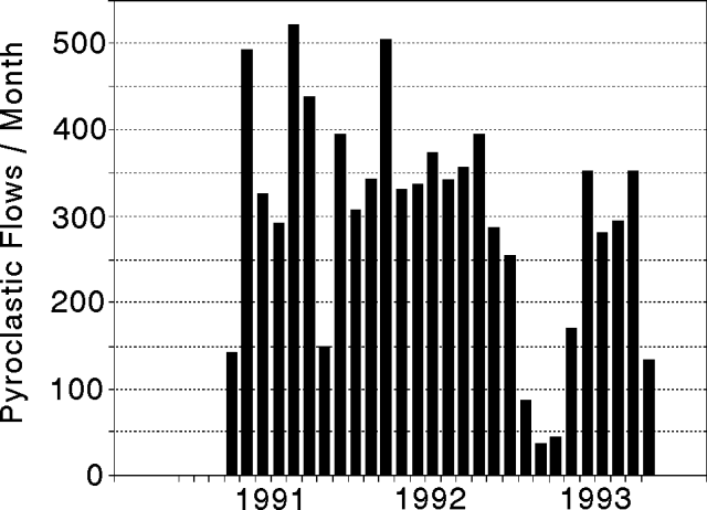 |
Figure 59. Monthly count of pyroclastic flows at Unzen, May 1991 to August 1993. Data courtesy of JMA. |
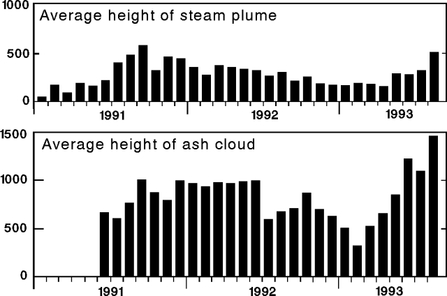 |
Figure 60. Monthly mean height at Unzen of the continuous steam plume from Jigokuato crater (top), and the ash cloud from pyroclastic flows (bottom), January 1991 to August 1993. Courtesy of JMA. |
The rainy season continued through August this year, with 772 mm of precipitation measured 3.5 km W of the summit, ~2-3x average. The rainfall total in July was 977 mm, after 1,165 mm of precipitation in June. The heavy rains since April have caused frequent debris flows along the Mizunashi and Nakao Rivers on the E flank of the volcano. Seismometers detected 13 debris flows in August. Most of these debris flows were small, but six houses were damaged on the 19th, bringing the total number of houses damaged to 1,415. Residents along the rivers have been issued temporary evacuation orders during periods of heavy rainfall.
Microearthquake activity at the lava dome complex began increasing on 26 July, peaking at 2,604 events on 7 August, the highest daily count since the current activity began. The previous high was 632 on 11 September 1992. By 17 August, activity had declined to the usual level of 10 events/day, and remained low through early September. Even so, a total of 12,946 microearthquakes was recorded in August, . . . the largest monthly count yet recorded (figure 61). The increased seismicity in July and early August caused no visible changes on the surface of the lava dome complex.
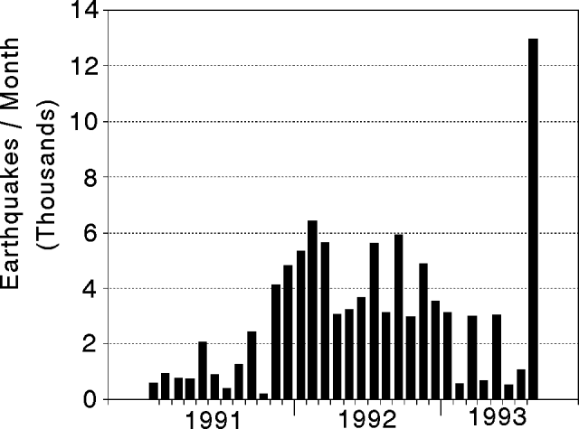 |
Figure 61. Monthly count of earthquakes at Unzen, January 1991 to August 1993. Data courtesy of JMA. |
Geological Summary. The massive Unzendake volcanic complex comprises much of the Shimabara Peninsula east of the city of Nagasaki. An E-W graben, 30-40 km long, extends across the peninsula. Three large stratovolcanoes with complex structures, Kinugasa on the north, Fugen-dake at the east-center, and Kusenbu on the south, form topographic highs on the broad peninsula. Fugendake and Mayuyama volcanoes in the east-central portion of the andesitic-to-dacitic volcanic complex have been active during the Holocene. The Mayuyama lava dome complex, located along the eastern coast west of Shimabara City, formed about 4000 years ago and was the source of a devastating 1792 CE debris avalanche and tsunami. Historical eruptive activity has been restricted to the summit and flanks of Fugendake. The latest activity during 1990-95 formed a lava dome at the summit, accompanied by pyroclastic flows that caused fatalities and damaged populated areas near Shimabara City.
Information Contacts: JMA; S. Nakada, Kyushu Univ.