Report on Unzendake (Japan) — September 1993

Bulletin of the Global Volcanism Network, vol. 18, no. 9 (September 1993)
Managing Editor: Edward Venzke.
Unzendake (Japan) Growth of lobe 11 generates pyroclastic flows; seismicity decreases
Please cite this report as:
Global Volcanism Program, 1993. Report on Unzendake (Japan) (Venzke, E., ed.). Bulletin of the Global Volcanism Network, 18:9. Smithsonian Institution. https://doi.org/10.5479/si.GVP.BGVN199309-282100
Unzendake
Japan
32.761°N, 130.299°E; summit elev. 1483 m
All times are local (unless otherwise noted)
Exogenous growth of lobe 11 . . . continued through early October (figure 62). The dome reached an approximate length of 900 m and width of 700 m with a maximum height difference of ~450 m from the top of lobe 10 (1,420 m) and the lower edge of lobe 11 (970 m). The eruption rate during this period was 1-2 x 10⁵ m3/day.
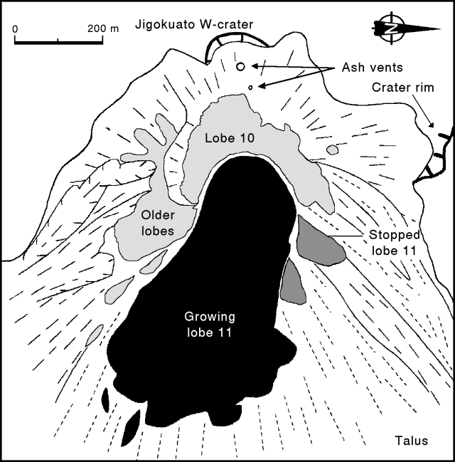 |
Figure 62. Sketch map of the lobes at Unzen, September 1993. Note that N is to the right. Courtesy of S. Nakada. |
Lobe 11 grew exogenously to the E, becoming ~800 m long and 400 m wide in mid-October and maintaining its ramp structure as it advanced forward. The frontal part of the lobe became steeper and the lava over the vent area gradually thickened. The front of the lobe was buried with its own collapsed material but still continued moving forward. The lobe widened as new lava was squeezed out along both sides, pushing older lava lobes around it and generating rockfalls and pyroclastic flows.
The monthly total of seismically counted pyroclastic flows was 138 in September, at similar levels to August (134). Growth at lobe 11 generated pyroclastic flows from partial collapses to the E and NE at a rate of about five events/day. However, no new property damage was caused by the flows. The largest flow of the month traveled 3 km NE in the Oshiga valley on 9 September with a seismic duration of 100 seconds. The highest ash cloud of the month, generated by a pyroclastic flow, rose 1,700 m above the summit on 16 September. Seismicity at the lava dome was relatively low in September with 1,032 small shocks recorded, significantly reduced from 12,946 in August. The number of residents evacuated . . . remained at 3,617, unchanged since early July.
Geological Summary. The massive Unzendake volcanic complex comprises much of the Shimabara Peninsula east of the city of Nagasaki. An E-W graben, 30-40 km long, extends across the peninsula. Three large stratovolcanoes with complex structures, Kinugasa on the north, Fugen-dake at the east-center, and Kusenbu on the south, form topographic highs on the broad peninsula. Fugendake and Mayuyama volcanoes in the east-central portion of the andesitic-to-dacitic volcanic complex have been active during the Holocene. The Mayuyama lava dome complex, located along the eastern coast west of Shimabara City, formed about 4000 years ago and was the source of a devastating 1792 CE debris avalanche and tsunami. Historical eruptive activity has been restricted to the summit and flanks of Fugendake. The latest activity during 1990-95 formed a lava dome at the summit, accompanied by pyroclastic flows that caused fatalities and damaged populated areas near Shimabara City.
Information Contacts: S. Nakada, Kyushu Univ; JMA.