Report on Whakaari/White Island (New Zealand) — October 1993

Bulletin of the Global Volcanism Network, vol. 18, no. 10 (October 1993)
Managing Editor: Edward Venzke.
Whakaari/White Island (New Zealand) Phreatic eruption; crater lake and fumarole temperatures decline
Please cite this report as:
Global Volcanism Program, 1993. Report on Whakaari/White Island (New Zealand) (Venzke, E., ed.). Bulletin of the Global Volcanism Network, 18:10. Smithsonian Institution. https://doi.org/10.5479/si.GVP.BGVN199310-241040
Whakaari/White Island
New Zealand
37.52°S, 177.18°E; summit elev. 294 m
All times are local (unless otherwise noted)
During fieldwork on 30 July an active vent, ~30-40 m in diameter, at the base of the NW wall of Wade Crater on the divide with Royce Crater (figure 20), was emitting a nearly translucent fume under moderate-high pressure. The fume quickly condensed on expansion to vivid white steam without any apparent ash. The floor of Wade Crater was occupied by a bright green lake ~90 m below the rim of the 1978/90 Crater Complex. Neither TV1 nor Princess Crater was emitting much steam.
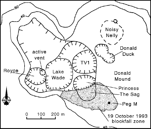 |
Figure 20. Sketch map of the 1978/90 Crater Complex of White Island showing crater locations as of 22 October 1993. Courtesy of IGNS. |
A magnetic survey revealed relatively small changes (up to 53 nT) compared to the May survey. A pattern similar to the changes between the 8 December 1992 and 18 May 1993 surveys appeared: a broad negative anomaly occurring over most of the crater floor but with an area of positive change NE of the 1978/90 Crater Complex. The broad negative anomaly could be due to a deeply centered heat source, and the positive change could be interpreted as a magnetic anomaly arising from shallow cooling in the active crater area. A sharp anomaly appeared at Donald Mound, negative to the N, positive to the S, and represents a newly recognized trend. The trend is most likely due to the effect of shallow heating 50-100 m beneath Donald Mound.
A gravity survey showed little change from the May measurements. A very slight positive anomaly runs through the center of the crater along its axis, flanked on either side by small negative anomalies. This effect can be attributed either to a gentle warping along the crater axis or to the migration of fluids.
A visit on 22 October was made to sample fumaroles and to determine the effects of the 19 October phreatic eruption, the most significant activity reported in several months. An E-type seismic event commenced at 1102 on 19 October and lasted for about an hour. The captain of a fishing boat 3 km W of White Island described several eruptions starting around 1100 and lasting a total of ~45 minutes. The ash plume was very pale gray, rose ~1 km above the summit of Mt. Gisborne, and was blown to the SE. A resident at Te Kaha, on the coast 50 km SE of White Island, reported hearing explosions and feeling vibrations at 1100 while the volcano was erupting. Te Kaha is directly in line with the breached Main Crater of White Island.
The most active feature in October at the 1978/90 Crater Complex was the vent on the NE side of Royce Crater. The vent was continuously emitting voluminous, ash-free steam that completely obscured its shape (arbitrarily depicted on figure 20 as circular). Wade Crater was completely occupied by a lake that has changed color since the July visit to a brilliant orange-yellow. The water temperature was 23°C as measured remotely by radiometer. Visual comparisons with photographs taken on 30 July when the lake was pea-soup green suggest that the lake level has risen roughly 10 m. A large delta was building up where the stream draining the largely inactive NW area of the 1978/90 Crater Complex enters the lake near the divide between Royce and Wade Craters. A smaller outwash fan occurs where a small stream is eroding the gap between Royce Crater and the 1978/90 Crater Complex wall. Lake Wade was estimated to be 110-130 m below the edge of the 1978/90 Crater rim at the point just S of The Sag. Twin fumaroles were conspicuous high on the E wall of Wade Crater adjacent to TV1 Crater, which itself was only weakly steaming. Princess Crater was inactive.
Researchers dug a new pit close to the rim of 1978/90 Crater Complex, S of The Sag, and exposed 20-25 cm of finely layered, fine-grained, light- to dark-gray or brick-red ash. In addition, banded gray and red ash at the base of this sequence correlates to May 1992 from comparison with photographs of earlier pits. One pit ~15 m SW of Peg M had 6-7 cm of ash since May 1992, but only 1-2 mm of dark-gray fine ash since 18 May. Hence there has been little ash accumulation in the area S of Donald Mound in the past five months. The eruption on 19 October deposited little ash, consistent with the observation that the eruption clouds were mostly steam.
Ballistic ejecta were scattered across an area approximately as shown in figure 20. Blocks varied in size up to 20 cm across, but most were <10 cm. Impact pits were spread an average of 1-2 m apart. Many blocks had hit the ground surface (moderately compacted fine ash) and skipped a short distance (<50 cm) making a small impact scar; others were imbedded where they landed, protruding from the surface. There were no large craters typical of high-energy impacts, and only a few of the larger blocks were buried where they had hit a sloping surface facing towards the 1978/90 Crater Complex (on the E side of The Sag). Skip trajectories mostly projected back towards the vent in Royce Crater, the presumed eruption source. Many large blocks were visible on the delta in Lake Wade near the vent, and may have been ejected by the same eruption. The lack of impact craters suggests that the ballistic rocks landed with low energy from near the highest point of their trajectories (Royce vent is ~130 m lower elevation than the fall field). It seems likely that the eruption occurred as a phreatic, vent-clearing "cannon shot" directed to the ESE.
The most common types of blocks were fragments of old, partly altered andesitic lava, and lumps of gray, coarse, very poorly sorted vent breccia. The latter are of variable compaction, contain much hydrothermally altered clastic material, and were soaked with acidic, mineralized water; they probably represent recently accumulated vent fill detritus rather than ancient vent-wall rocks. Among the ejecta were irregular chunks of brine-soaked indurated volcaniclastic sandy-silty sediment showing intense folding and crenulation on a mm-cm scale; their origin and significance is not known. There were a number of andesitic scoriaceous bombs among the ejecta at the W end of the fall field. All were ash coated and none were found in impact scars. It is possible, but not proven, that they are juvenile bombs from the 19 October eruption.
Temperatures of springs and fumaroles have steadily decreased over the last four visits. Between 27 August and 27 October, the temperature at Noisy Nellie fumarole declined from 292 to 248°C, and the lake in Wade Crater went from 45.5 to 21.5°C.
Geological Summary. The uninhabited Whakaari/White Island is the 2 x 2.4 km emergent summit of a 16 x 18 km submarine volcano in the Bay of Plenty about 50 km offshore of North Island. The island consists of two overlapping andesitic-to-dacitic stratovolcanoes. The SE side of the crater is open at sea level, with the recent activity centered about 1 km from the shore close to the rear crater wall. Volckner Rocks, sea stacks that are remnants of a lava dome, lie 5 km NW. Descriptions of volcanism since 1826 have included intermittent moderate phreatic, phreatomagmatic, and Strombolian eruptions; activity there also forms a prominent part of Maori legends. The formation of many new vents during the 19th and 20th centuries caused rapid changes in crater floor topography. Collapse of the crater wall in 1914 produced a debris avalanche that buried buildings and workers at a sulfur-mining project. Explosive activity in December 2019 took place while tourists were present, resulting in many fatalities. The official government name Whakaari/White Island is a combination of the full Maori name of Te Puia o Whakaari ("The Dramatic Volcano") and White Island (referencing the constant steam plume) given by Captain James Cook in 1769.
Information Contacts: B. Christenson and C. Wood, IGNS Wairakei; J.L. Smellie, British Antarctic Survey, Cambridge.