Report on Iliwerung (Indonesia) — October 1993
Bulletin of the Global Volcanism Network, vol. 18, no. 10 (October 1993)
Managing Editor: Edward Venzke.
Iliwerung (Indonesia) Follow-up on Hobal vent eruption and 1979 tsunami
Please cite this report as:
Global Volcanism Program, 1993. Report on Iliwerung (Indonesia) (Venzke, E., ed.). Bulletin of the Global Volcanism Network, 18:10. Smithsonian Institution. https://doi.org/10.5479/si.GVP.BGVN199310-264250
Iliwerung
Indonesia
8.532°S, 123.573°E; summit elev. 583 m
All times are local (unless otherwise noted)
In September, Hobal vent on the [ESE] submarine flanks of Iliwerung volcano (figure 1) produced an eruption that broke the ocean surface (18:08).... During the eruption pyroclastic material sank within ~200 m of the point where it penetrated the ocean surface, consequently no samples were obtained. This suggests that the erupted material lacked sufficient closed vesicles to allow it to float.
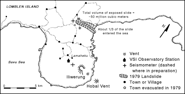 |
Figure 1. Map showing Iliwerung volcano, Hobal vent, and the known extent of the 1979 landslide that triggered a tsunami. Note that N is to the upper right. Courtesy of VSI. |
Depth to the Hobal vent has never been measured, though in 1979 the VSI estimated it at 50 m. The bathymetry of this region is also significant because of its relevance to tsunamis. A 1979 landslide NW of Iliwerung reached the sea (figure 1), and probably aided by additional submarine slumping, triggered a tsunami that killed hundreds of people. Several areas evacuated prior to the 1979 landslide and tsunami still remain evacuated. Relevant aspects of the tectonic setting, and the effects of a 1992 earthquake-triggered tsunami on the N side of Flores Island are discussed by Yeh and others (1993).
Seismic data were acquired by VSI prior to the September Hobal eruption. The data were received at Lamaheku seismic station, at ~75-m elevation on the W flank of Iliwerung, 4.5 km from the Hobal vent. The seismic record is incomplete, but for July to September 1992, the number of volcanic B-type earthquakes averaged more than 70/month, reaching ~96 in September 1992. A gap in the record occurred in early 1993, but later in the year B-type earthquakes progressively increased from ~30 in May to 60 in September. Thus, the B-type events increased prior to the September eruption, but at least one interval with more B-type events passed without reports of concurrent eruptions.
VSI has informed local governments about the hazards of future eruptions, and has established a volcanic danger area that includes at least four communities on Iliwerung. Local VSI staff continue to monitor the region, and as of 1 November, were in the process of installing a new seismic station.
Reference. Yeh, H., Imamura, F., Synolakis, C., Yoshinobu T., Liu, P., and Shi, S., 1993, The Flores Island tsunamis: Eos, Transactions of the American Geophysical Union, v. 74, no. 33.
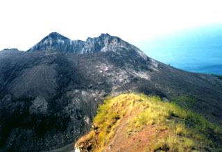
Geological Summary. Constructed on the southern rim of the Lerek caldera, Iliwerung forms a prominent south-facing peninsula on Lembata (formerly Lomblen) Island. Craters and lava domes have formed along N-S and NW-SE lines on the complex volcano; activity has been observed at vents from the summit to the submarine SE flank. The summit lava dome was formed during an eruption in 1870. In 1948 the Iligripe lava dome grew on the E flank at 120 m elevation. Beginning in 1973-74, when three ephemeral islands were formed, submarine eruptions began on the lower ESE flank at a vent named Hobal; several other eruptions have since taken place at this vent.
Information Contacts: W. Tjetjep, VSI.