Report on Bezymianny (Russia) — October 1993
Bulletin of the Global Volcanism Network, vol. 18, no. 10 (October 1993)
Managing Editor: Edward Venzke.
Bezymianny (Russia) Additional explosions produce ashfall; extrusive dome growth
Please cite this report as:
Global Volcanism Program, 1993. Report on Bezymianny (Russia) (Venzke, E., ed.). Bulletin of the Global Volcanism Network, 18:10. Smithsonian Institution. https://doi.org/10.5479/si.GVP.BGVN199310-300250
Bezymianny
Russia
55.972°N, 160.595°E; summit elev. 2882 m
All times are local (unless otherwise noted)
A strong explosive eruption began at about 1600 on 21 October . . . . This eruption appears to be the largest from Bezymianny since 1956. Ash . . . began falling on the N part of Bering Island (Kommandorski Islands), ~515 km ESE . . ., between 2300 on 21 October and 0500 the next day. The deposit consisted of a very thin layer of fine dark ash. No ashfall was reported at Shemya Air Force Base (Shemya Island), 1,275 km E . . . in the western Aleutians. Though . . . obscured on 22 October, a gas-and-steam column was visible above the cloud cover to an unknown altitude. That morning, the NWS observed a possible volcanic plume on satellite imagery extending for several tens of kilometers along the Kamchatkan coast.
Heavy ashfall frequently obscured the volcano through 24 October, but ash plumes were observed rising to 8-12 km altitude on 23-24 October. The eruption plume reached 15 km altitude on the afternoon of 24 October, and extended >100 km to the ESE. The resulting ash layer was >10 mm thick at a seismic station 15 km NE, and 5 mm thick at a weather station 30 km SE. Satellite imagery on 24 October showed heavy banded frontal clouds moving NNE over the Kamchatka Peninsula with no definitive ash cloud visible. The Level of Concern Color Code was raised to Red on 24 October by the KVERT, indicating that large ash eruptions were expected.
Strong seismicity on 25-26 October, including 8 hours of tremor, indicated continuing eruptive activity, although clouds prevented observations 24-28 October. Satellite imagery on 25-26 October continued to show layered frontal clouds over the Kamchatka Peninsula with no definitive ash cloud. The duration of volcanic tremor decreased from 8 hours/day on 25 October to 45 minutes/day on 28 October. This decline in seismicity prompted KVERT to lower the Level of Concern Color Code to Yellow (volcano is restless), however, the level was soon raised back to Orange (small ash eruptions expected/confirmed) following renewed activity.
A violent explosive outburst at 0245-0330 on 28 October resulted in ashfall in the town of Kliuchi, 45 km NNE. Another explosion at 0300 on 29 October sent an ash plume to the NNE and deposited 2 mm of ash in Kliuchi 1-2 hours later. Seismicity again indicated continued activity from 30 October to 2 November while the volcano was obscured by clouds. Volcanic tremor was recorded for 30 minutes on 30 October and for 4 hours on 31 October, with events located beneath the volcano. Earthquakes and volcanic tremor were detected again on 1-2 November. As of 6 November, about one hour/day of volcanic tremor was being registered, indicative of continued extrusive dome growth; an ash plume was no longer visible above the summit. The decrease in activity resulted in a lowering of the Level of Concern Color Code from Orange to Yellow.
TOMS data from the Meteor-3 satellite in the second half of October did not reveal an SO2 cloud . . . . High latitude coverage in the winter is extremely limited due to reduced daylight hours, resulting in spotty coverage around Bezymianny. However, it is possible that SO2 concentrations were below the TOMS detection levels, or that the cloud was missed by TOMS coverage.
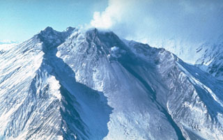
A KVERT geologist who visited the volcano on 12 November reported that activity had declined but was continuing. A steam-and-gas plume with a small amount of ash rose about 3 km above the crater rim; the plume was directed to the ESE for >50 km and light ashfall was occurring along the axis. The extrusive dome was still growing, but the SE side had been partially destroyed. Viscous lava was being emitted from the dome vent. Pyroclastic flows formed in the first days of the eruption had traveled ~14-16 km. Near the base of the dome, the pyroclastic-flow deposits were estimated to be ~15 m thick. At 1300 on 12 November an earthquake under the volcano caused rockslides on the dome slopes.
Geological Summary. The modern Bezymianny, much smaller than its massive neighbors Kamen and Kliuchevskoi on the Kamchatka Peninsula, was formed about 4,700 years ago over a late-Pleistocene lava-dome complex and an edifice built about 11,000-7,000 years ago. Three periods of intensified activity have occurred during the past 3,000 years. The latest period, which was preceded by a 1,000-year quiescence, began with the dramatic 1955-56 eruption. This eruption, similar to that of St. Helens in 1980, produced a large open crater that was formed by collapse of the summit and an associated lateral blast. Subsequent episodic but ongoing lava-dome growth, accompanied by intermittent explosive activity and pyroclastic flows, has largely filled the 1956 crater.
Information Contacts: V. Kirianov, IVGG; T. Miller, AVO; J. Lynch, SAB; G. Bluth, GSFC.