Report on Pacaya (Guatemala) — November 1993

Bulletin of the Global Volcanism Network, vol. 18, no. 11 (November 1993)
Managing Editor: Richard Wunderman.
Pacaya (Guatemala) Explosions and lava flows; summary of 1992-93 activity
Please cite this report as:
Global Volcanism Program, 1993. Report on Pacaya (Guatemala) (Wunderman, R., ed.). Bulletin of the Global Volcanism Network, 18:11. Smithsonian Institution. https://doi.org/10.5479/si.GVP.BGVN199311-342110
Pacaya
Guatemala
14.382°N, 90.601°W; summit elev. 2569 m
All times are local (unless otherwise noted)
During an overflight on 8 November 1993, Stephen O'Meara saw brief glimpses of MacKenney crater (figure 12) through breaks in the clouds. A small cone was seen at the center of the horseshoe-shaped MacKenney crater, which was breached to the S. Incandescent lava issued from a vent near the SW wall of MacKenney crater and flowed SE across the summit crater floor. The SE slope was covered by a fresh lava flow with overlapping lobes that extended two-thirds of the way down the flank. On 10 November, ash eruptions originating from one or more vents in MacKenney crater were observed from the S near Los Pocitos at intervals of about 30 seconds, with larger explosions occurring several times a minute to once every five minutes. At night three incandescent lava channels could be seen descending the SE flank.
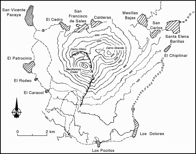 |
Figure 12. Sketch map of Pacaya and nearby towns. Hachured arcuate line indicates the caldera rim. Letter "x" refers to MacKenney crater, "y" to the pre-1965 cone, and "z" to the 1984 spatter cone. Contour interval 100 m; contour intervals around MacKenney crater are approximate. |
Participants of the Santa María Decade Volcano Workshop observed MacKenney crater ash eruptions from vantage points on Pacaya's N caldera rim. The previous night, 12 November, strong detonations from Pacaya were heard in Antigua, Guatemala, 25 km NW. Following destruction of the upper cone by strong explosions in 1989 and 1991, MacKenney cone had rebuilt itself to a height comparable to that in 1991. Its summit was slightly higher than the pre-1965 cone immediately to the E (figure 12), and was again visible from San Francisco de Sales on the N flank. A line of fumaroles marked the mostly buried N rim of the 1989 crater. Fresh lava flows with pronounced levees from eruptions in 1990 and 1991 coated the N and NW flanks, and covered the moat floor between the caldera rim and MacKenney cone, almost burying the upslope side of the prominent spatter cone from a 1984 eruption (figure 12).
Explosions several times a minute to every few minutes ejected blocks and ash to heights of about 150 m, accompanied by detonations. Larger pulsating ash columns were also seen punching through the persistent summit cloud cap during brief observations the following day from 20 km E on the road to Cuilapa.
Summary of 1992 and 1993 activity. Following a period of increased activity June to September 1992 (17:08) explosive activity declined, although lava flows continued to travel about 1.5 km to the SW.
An increase in the amplitude of explosion seismicity took place at the end of October and beginning of November 1992. After 15 November, the frequency of explosions increased (figure 13), reaching 4,800-5,000 explosions/day around 25 December, and 7,800 explosions/day in early January 1993.
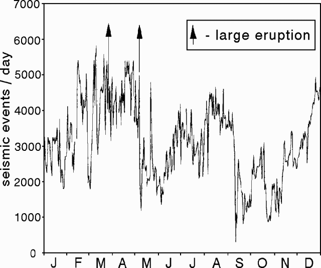 |
Figure 13. Daily number of explosions of Pacaya during 1992 determined from seismogram records. Vertical arrows mark large eruptions. Courtesy of Otoniel Matías (INSIVUMEH). |
On 10 January 1993, a large explosive eruption lasting 4 hours was accompanied by collapse of the S rim of MacKenney crater, producing a hot avalanche that traveled 3.5 km to the SW, cutting the road between El Caracol and Los Pocitos. The crater-rim collapse, the first since the birth of MacKenney crater in 1961, involved an area 75-80 m wide and 30 m deep. During the eruption, a small lava flow traveled down a 7-15 m deep channel formed by the crater-rim collapse to reach 1,600 m elevation.
Column collapse produced a nuée ardente that traveled 2 km SE to 1,600 m elevation, leaving a deposit just 7-10 cm thick. The color of ash in the 4-km-high eruption column changed from gray to red as it passed through a rain cloud. Ashfall was distributed NW to a depth of 6 cm at a distance of 5 km from the crater. Traces of ash fell in Guatemala City and beyond, causing some damage to jet aircraft turbines. Ashfall burned leaves to 2.3 km NE of the crater and dehydrated leaves to 5-7 km away, which later fell. Residents of villages in this region suffered irritation to the eyes and nose. In the two weeks following the eruption, wind-blown ash from the nuée ardente deposit reached heights of >3.5 km and was redistributed 40-45 km to the SW.
INSIVUMEH and CONE (Comitte Nacional de Emergencia) had predicted a strong eruption 3 days prior to 10 January, and the villages of El Caracol (3 km SW) and El Patrocinio (4 km W) were evacuated during the eruption. Following the eruption, typical activity continued at Pacaya, with the daily number of explosions decreasing intermittently from 7,000 to about 3,000/day by mid-year (figure 14). An increase in the amplitude of explosion seismicity in mid-May was not accompanied by stronger eruptions. Lava flows traveled almost continuously for about 1 km down the S flank from a source just below the breached S crater rim.
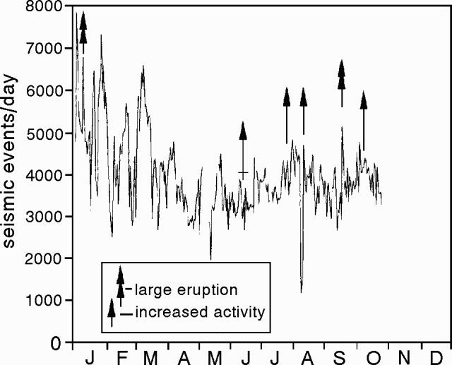 |
Figure 14. Daily number of explosions of Pacaya during 1993 determined from seismogram records. Vertical double arrow marks large eruptions, single arrow periods of increased activity. Courtesy of Otoniel Matías. (INSIVUMEH). |
On the evening of 21 September, a vertical eruption column 2-2.5 km high with a 300-400 m incandescent base was accompanied by vigorous lava effusion and strong tremor. Lava fountains reached 700 m heights at the beginning of the 7-hour eruption, and were most vigorous for 9-15 minutes shortly after midnight. Ash fell at El Caracol, although no damage was recorded. Lava flows traveled 1 km to the S over the 10 January flows.
At the beginning of the second week of October the frequency and magnitude of activity increased for 9 hours. A dark ash column rose to a sustained height of 400 m, depositing ash to the W. The lower 200 m of the column, which reached heights of 700-800 m, was incandescent.
Geological Summary. Eruptions from Pacaya are frequently visible from Guatemala City, the nation's capital. This complex basaltic volcano was constructed just outside the southern topographic rim of the 14 x 16 km Pleistocene Amatitlán caldera. A cluster of dacitic lava domes occupies the southern caldera floor. The post-caldera Pacaya massif includes the older Pacaya Viejo and Cerro Grande stratovolcanoes and the currently active Mackenney stratovolcano. Collapse of Pacaya Viejo between 600 and 1,500 years ago produced a debris-avalanche deposit that extends 25 km onto the Pacific coastal plain and left an arcuate scarp inside which the modern Pacaya volcano (Mackenney cone) grew. The NW-flank Cerro Chino crater was last active in the 19th century. During the past several decades, activity has consisted of frequent Strombolian eruptions with intermittent lava flow extrusion that has partially filled in the caldera moat and covered the flanks of Mackenney cone, punctuated by occasional larger explosive eruptions that partially destroy the summit.
Information Contacts: Otoniel Matías, INSIVUMEH; Lee Siebert, Smithsonian Institution; Stephen O'Meara, Sky & Telescope.