Report on Yanteles (Chile) — November 1993
Bulletin of the Global Volcanism Network, vol. 18, no. 11 (November 1993)
Managing Editor: Richard Wunderman.
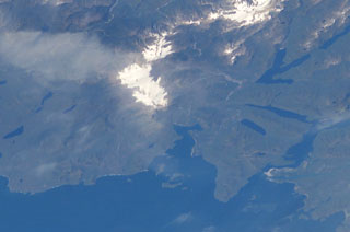
Yanteles (Chile) Active fumaroles, some issuing from a hole in the snow-and-ice cap
Please cite this report as:
Global Volcanism Program, 1993. Report on Yanteles (Chile) (Wunderman, R., ed.). Bulletin of the Global Volcanism Network, 18:11. Smithsonian Institution. https://doi.org/10.5479/si.GVP.BGVN199311-358049
Yanteles
Chile
43.469°S, 72.782°W; summit elev. 1790 m
All times are local (unless otherwise noted)
Aerial observations on 21 September 1993 provided a clearer overview of fumarole locations. The aerial observations took place at noon and 1700 and included photo and video records. Two main vent areas were recognized and described. One vent area lies at the S side of the upper ridge segment, and covers an approximate area of 0.05-0.2 km2. This area resembled the flanks of a dome and emitted yellow-colored steam. The other vent area lies ~2 km to the NNE of the previously described one, and exits through a 100-m-wide perforation through Yanteles snow-and-ice cap. This vent area emitted a roughly 100-m high, white-to-yellow plume. Neither this vent area nor any other site in vicinity of the ridge has the morphology of a crater.
Geological Summary. Little-known glacier-covered Yanteles volcano in southern Chile is at the corner of a volcanic massif located 60 km S of the city of Chaiten, with higher eroded peaks about 5 km E and along a ridge extending 10 km SW. Several Holocene tephra layers have been attributed to this volcano. There were reports of an eruption at the time of the 20 February 1835 Chile earthquake, and Sapper (1917) stated that previously unseen black areas were observed there after the 1835 earthquake, but the nature of this activity is not clear.
Information Contacts: J. Naranjo, SERNAGEOMIN, Santiago.