Report on Pinatubo (Philippines) — January 1994
Bulletin of the Global Volcanism Network, vol. 19, no. 1 (January 1994)
Managing Editor: Richard Wunderman.
Pinatubo (Philippines) Seismicity increases for 10 days then declines
Please cite this report as:
Global Volcanism Program, 1994. Report on Pinatubo (Philippines) (Wunderman, R., ed.). Bulletin of the Global Volcanism Network, 19:1. Smithsonian Institution. https://doi.org/10.5479/si.GVP.BGVN199401-273083
Pinatubo
Philippines
15.13°N, 120.35°E; summit elev. 1486 m
All times are local (unless otherwise noted)
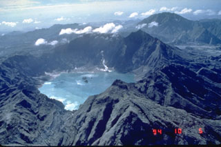
Seismic activity significantly increased starting on 8 February and peaked at >200 high-frequency volcanic earthquakes on 11 February. The number of explosion earthquakes and duration of low-frequency harmonic tremor also increased during this period. Swarms of shallow volcanic earthquakes were recorded at the CRAZ station on the N caldera rim. Some of these events were also detected by the FNGZ station located 9 km SE of the caldera. Aerial surveys on 25 January and 8 February revealed phreatic cones and explosion pits on the NW shore of the lake and on the caldera floor near the N wall. The W half of the caldera lake also appeared muddy, but there was no sign of dome growth. These events are similar to those seen before the dome-building activity in July 1992, and may represent a continuation of that activity.
PHIVOLCS interpreted these observations as indicative of renewed movement of magma beneath the volcano that could result in lava-dome growth and small to moderate eruptions with columns < 6 km high. Because of this possibility, the hazard status was raised to Alert Level 3, indicating that eruptive activity as described above could occur within a period of weeks. COSPEC measurements of SO2 flux were attempted on 15 February, but were unsuccessful because the steam plume dissipated before rising above the crater rim.
Starting on 18 February, seismicity began to decrease. Explosion earthquakes and tremor gradually dropped to 0-2 events/day by 21 February, with no shallow earthquakes recorded at the CRAZ station. On 22 February the CRAZ station recorded 10 high-frequency volcanic earthquakes; the FNGZ station recorded 4. Low-frequency harmonic tremor was also recorded for 77 minutes. Thick cloud cover at the summit prevented visual observations of steaming activity. If seismicity continues to decrease through the first week of March, the hazard status will be lowered back to Alert Level 2. As a precaution against possible secondary explosions from the still-hot 1991 pyroclastic-flow deposits, the public continues to be advised to observe the 10-km-radius danger zone.
Geological Summary. Prior to 1991 Pinatubo volcano was a relatively unknown, heavily forested lava dome complex located 100 km NW of Manila with no records of historical eruptions. The 1991 eruption, one of the world's largest of the 20th century, ejected massive amounts of tephra and produced voluminous pyroclastic flows, forming a small, 2.5-km-wide summit caldera whose floor is now covered by a lake. Caldera formation lowered the height of the summit by more than 300 m. Although the eruption caused hundreds of fatalities and major damage with severe social and economic impact, successful monitoring efforts greatly reduced the number of fatalities. Widespread lahars that redistributed products of the 1991 eruption have continued to cause severe disruption. Previous major eruptive periods, interrupted by lengthy quiescent periods, have produced pyroclastic flows and lahars that were even more extensive than in 1991.
Information Contacts: PHIVOLCS.

