Report on Unzendake (Japan) — January 1994

Bulletin of the Global Volcanism Network, vol. 19, no. 1 (January 1994)
Managing Editor: Richard Wunderman.
Unzendake (Japan) New lava lobe is extruded; seismicity decreases
Please cite this report as:
Global Volcanism Program, 1994. Report on Unzendake (Japan) (Wunderman, R., ed.). Bulletin of the Global Volcanism Network, 19:1. Smithsonian Institution. https://doi.org/10.5479/si.GVP.BGVN199401-282100
Unzendake
Japan
32.761°N, 130.299°E; summit elev. 1483 m
All times are local (unless otherwise noted)
Microearthquakes beneath the lava dome, which increased in mid-December, suddenly decreased to 20-50/day after 6 January 1994. The ground deformation that began in early November ceased in early January, based on EDM measurements by the Geological Survey of Japan, at the same time that seismicity decreased. A new lobe (lobe 12) appeared in a graben at the top of the dome on 15 January (figure 66). The peak of the lobe, where lava was extruding, was at 1,420 m elevation. During endogenous growth the graben deepened and lobe 12 swelled to the SW, allowing lava extrusion from the base. The new lobe grew at a rate of ~0.1 x 10⁶ m3/day during the first week, reaching dimensions of ~140 m long, 110 m wide, and 30 m high. The lobe was composed of lava blocks, reflecting the low eruption rate. Lava samples of lobe 12 have SiO2 contents of about 64 wt.%, almost the same as previous lobes.
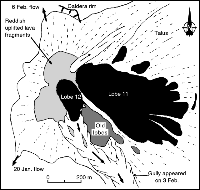 |
Figure 66. Sketch map of the lava dome at Unzen, early February 1994. Arrows indicate the main direction of pyroclastic flows and rockfalls from mid-January to mid-February. Courtesy of Setsuya Nakada. |
A pyroclastic flow on 20 January traveled 1.5 km SW, reaching the small Akamatsu valley. The pyroclastic flow was due to partial collapse of both lava blocks S of lobe 12 and talus deposits from previous collapses that had filled the crater floor S of the dome. The flow descended a gully, incorporating prehistoric deposits from the gully walls. The gully had developed during rainy seasons since the start of the 1991 eruption, and was the source for debris-flow material. The pyroclastic flow burned trees in the valley and produced ashfall a few kilometers away from the dome. Tremor caused by this event lasted 910 seconds, much longer than most previous pyroclastic flows. This long tremor duration is thought to have been caused by successive small-scale collapses from the dome. The estimated volume of the pyroclastic-flow deposits is several hundred thousand cubic meters.
Collapses generated a total of 75 pyroclastic flows in January, the most since October 1993. The flows eroded deeply into the basement rocks (pyroclastic-flow deposits of ~4 Ka) on the SE margin of the talus apron. A pyroclastic flow on 31 January, from lobe 12, traveled 2.5 km SE, the longest distance in January. Fresh, gray-colored lava from lobe 12 appeared within the horseshoe-shaped crater formed by the collapses. By 3 February, the total volume of lobe 12 and adjacent talus that had collapsed was ~1 x 10⁶ m3. Rockfalls occurred mainly to the NW.
Pyroclastic flows on 3 February traveled about 3.5 km from their source. A field inspection the next day showed that the resulting deposits contained larger amounts of cooled oxidized blocks and mud-coated blocks, derived from older lobes and prehistoric basement deposits, respectively. The amount of juvenile materials in these deposits (fresh, hot blocks and fragments) was as low as 10%. On 6 February, pyroclastic flows descended NNW beyond the notch of the caldera rim, from which andesitic lava flowed N in 1663. Previously, talus and pyroclastic-flows that moved N had remained within the caldera.
The growth rate of lobe 12 declined to3/day in early February, and no fresh lava appeared on the lobe surface. Endogenous growth then started; upward swelling produced NW-SE trending cracks on the surface of the lobe. The entire lava dome also started to expand NW at a rate of ~1 m/day in early February. Field inspection by staff of the SEVO showed pressure ridges and low-angle reverse faults in the NW crater floor near the dome, implying pressure from the dome. These phenomena resembled those during the endogenous events of March-April and November-December 1993.
The monthly total of microearthquakes in January was 1,863, a significant decrease from December (25,340) and November (2,662) (18:11-12). There have not been any earthquakes felt at the UWS in early February. Only 27 earthquakes were felt in January, compared to 170 in December (18:12).
Geological Summary. The massive Unzendake volcanic complex comprises much of the Shimabara Peninsula east of the city of Nagasaki. An E-W graben, 30-40 km long, extends across the peninsula. Three large stratovolcanoes with complex structures, Kinugasa on the north, Fugen-dake at the east-center, and Kusenbu on the south, form topographic highs on the broad peninsula. Fugendake and Mayuyama volcanoes in the east-central portion of the andesitic-to-dacitic volcanic complex have been active during the Holocene. The Mayuyama lava dome complex, located along the eastern coast west of Shimabara City, formed about 4000 years ago and was the source of a devastating 1792 CE debris avalanche and tsunami. Historical eruptive activity has been restricted to the summit and flanks of Fugendake. The latest activity during 1990-95 formed a lava dome at the summit, accompanied by pyroclastic flows that caused fatalities and damaged populated areas near Shimabara City.
Information Contacts: JMA; S. Nakada, Kyushu Univ.