Report on Pinatubo (Philippines) — February 1994
Bulletin of the Global Volcanism Network, vol. 19, no. 2 (February 1994)
Managing Editor: Richard Wunderman.
Pinatubo (Philippines) No plume observed, but seismicity remains above background
Please cite this report as:
Global Volcanism Program, 1994. Report on Pinatubo (Philippines) (Wunderman, R., ed.). Bulletin of the Global Volcanism Network, 19:2. Smithsonian Institution. https://doi.org/10.5479/si.GVP.BGVN199402-273083
Pinatubo
Philippines
15.13°N, 120.35°E; summit elev. 1486 m
All times are local (unless otherwise noted)
Clouds generally obscured the summit of Pinatubo on 13-14 March, but during cloud breaks no plume was visible. Even though no plume has substantiated an increase in the rate of degassing, above-background seismicity has led PHIVOLCS to maintain Alert Level 3 status.
Pinatubo seismic stations—CRAZ, located on the N rim of the caldera, and FNGZ, located 9 km SE from the caldera—both operated in mid-March. During a 24-hour period beginning at 0600 on 12 March, CRAZ and FNGZ recorded 17 and 6 high-frequency earthquakes respectively; in the next 24 hours CRAZ and FNGZ recorded 238 and 50 high-frequency earthquakes. During the second interval FNGZ also recorded 4 explosions with maximum duration of 4 minutes; one of these explosions initiated 24 minutes of harmonic tremor. Explosions and harmonic tremor may signify magmatic degassing beneath the caldera.
The alert status of Pinatubo volcano has remained at Level 3 since February, indicating that eruptive activity could occur within a period of weeks. The 10-km-radius danger zone remains in effect as a precaution against possible secondary explosions from the still-hot 1991 pyroclastic-flow deposits.
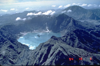
Geological Summary. Prior to 1991 Pinatubo volcano was a relatively unknown, heavily forested lava dome complex located 100 km NW of Manila with no records of historical eruptions. The 1991 eruption, one of the world's largest of the 20th century, ejected massive amounts of tephra and produced voluminous pyroclastic flows, forming a small, 2.5-km-wide summit caldera whose floor is now covered by a lake. Caldera formation lowered the height of the summit by more than 300 m. Although the eruption caused hundreds of fatalities and major damage with severe social and economic impact, successful monitoring efforts greatly reduced the number of fatalities. Widespread lahars that redistributed products of the 1991 eruption have continued to cause severe disruption. Previous major eruptive periods, interrupted by lengthy quiescent periods, have produced pyroclastic flows and lahars that were even more extensive than in 1991.
Information Contacts: PHIVOLCS.

