Report on Unzendake (Japan) — February 1994

Bulletin of the Global Volcanism Network, vol. 19, no. 2 (February 1994)
Managing Editor: Richard Wunderman.
Unzendake (Japan) Fewer pyroclastic flows; deformation on the N flank
Please cite this report as:
Global Volcanism Program, 1994. Report on Unzendake (Japan) (Wunderman, R., ed.). Bulletin of the Global Volcanism Network, 19:2. Smithsonian Institution. https://doi.org/10.5479/si.GVP.BGVN199402-282100
Unzendake
Japan
32.761°N, 130.299°E; summit elev. 1483 m
All times are local (unless otherwise noted)
The new lobe (##12) that appeared in mid-January (19:01) began endogenous growth in early February. The lava supply rate from early February to early March was several tens of thousands of m3/day. A spine-like cone that appeared just W of lobe 12 in early February moved 3 m/day to the NW and grew 1.5 m higher each day. By early March the cone was about 200 m across and 80 m high. The elevation of this cone reached 1,485 m, 235 m above the crater floor around the dome. During growth of the cone, the lava dome was swelling to the NW; lava blocks on the N talus slope moved 1.2 m/day.
Due to swelling of the dome, rockfalls went primarily to the NNW, advancing the foot of the talus slope 50 m since the beginning of the year. The crater floor around the NW side of the dome underwent strong deformation, due to pressure from the growing cone; thrusts, pressure ridges, and open cracks developed. The degree of deformation decreased with distance from the dome, and extended about 200 m from the talus front. The thrusts and pressure ridges developed sub-parallel to the talus front. Thrusted slabs were up to 100 m long and 50 m wide. Small-scale grabens (~10 m wide) and collapse holes (a few meters across) appeared in areas with a high density of open cracks. Both grabens and open cracks were roughly oriented towards the cone.
A GPS survey by the SEVO showed that five observation points on the floor of the dome moved away from the cone. The greatest movement was recorded at a point in the E-most block of the deformed area. This fast-moving block (200 m wide by 300 m long), bounded by lateral and reverse faults, had moved N at a speed of 50-70 cm/day since late January. Displacements along the faults increased over time until they could easily be recognized from the ground and from a helicopter.
Crest line measurements determined by theodolite from the UWS documented deformation on the W side of the dome (figure 67). Between 10 February and 6 March the lava dome was uplifted by ~50 m. Vertical growth was continuing at a rate of 1-2 m/day as of mid-March. An EDM survey by the GSJ revealed 20 m of shortening on the N flank at a rate of 50 cm/day in February and 80 cm/day in early March.
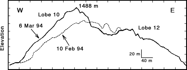 |
Figure 67. Profile of the Unzen lava dome on 10 February and 6 March determined by theodolite measurements from ~2 km SSW of the dome. Courtesy of JMA. |
Pyroclastic flows generated by lava-dome collapses on 2-3 February traveled 3-3.5 km SE, reaching the small town of Fukae-cho. On 6 February another pyroclastic flow went 500 m to the N. If lava extrusion and ground deformation continue, pyroclastic flows caused by collapse of part of the lava dome could travel >4 km down the N flank. The number of pyroclastic flows gradually decreased after 6 February; none were detected 11-27 February. Seismicity during the first three weeks of February consisted of 40-50 microearthquakes/day. Seismic activity gradually increased to >100 events on the 23rd. Pyroclastic flows in February totaled 80, and there were 1,726 microearthquakes recorded. These values are similar to January.
Geological Summary. The massive Unzendake volcanic complex comprises much of the Shimabara Peninsula east of the city of Nagasaki. An E-W graben, 30-40 km long, extends across the peninsula. Three large stratovolcanoes with complex structures, Kinugasa on the north, Fugen-dake at the east-center, and Kusenbu on the south, form topographic highs on the broad peninsula. Fugendake and Mayuyama volcanoes in the east-central portion of the andesitic-to-dacitic volcanic complex have been active during the Holocene. The Mayuyama lava dome complex, located along the eastern coast west of Shimabara City, formed about 4000 years ago and was the source of a devastating 1792 CE debris avalanche and tsunami. Historical eruptive activity has been restricted to the summit and flanks of Fugendake. The latest activity during 1990-95 formed a lava dome at the summit, accompanied by pyroclastic flows that caused fatalities and damaged populated areas near Shimabara City.
Information Contacts: JMA; S. Nakada, Kyushu Univ.