Report on Whakaari/White Island (New Zealand) — March 1994

Bulletin of the Global Volcanism Network, vol. 19, no. 3 (March 1994)
Managing Editor: Richard Wunderman.
Whakaari/White Island (New Zealand) Small ash eruptions and steam plumes
Please cite this report as:
Global Volcanism Program, 1994. Report on Whakaari/White Island (New Zealand) (Wunderman, R., ed.). Bulletin of the Global Volcanism Network, 19:3. Smithsonian Institution. https://doi.org/10.5479/si.GVP.BGVN199403-241040
Whakaari/White Island
New Zealand
37.52°S, 177.18°E; summit elev. 294 m
All times are local (unless otherwise noted)
The lake in Wade Crater was first observed in March 1993. Following an ash-bearing phreatic eruption on 19 October 1993, the crater lake temperature decreased from ~45 to 22°C. By the end of November, lake temperature had again risen to >50°C, the water color was green-yellow, and there was strong bubbling and geyser-like activity near the W shore.
Fieldwork on 14 January 1994 revealed that the lake in Wade Crater had shrunk to a small pond of bubbling gray water at its former W end. Noise from the fumarole in the NW corner of Royce Crater, where a lake was present in early December, was loud enough to cause discomfort without ear protection. The next day, this fumarole emitted brown ash that formed a plume to 200 m above the main crater floor. Ballistic blocks up to 50 cm in diameter were thrown as high as 30 m above the vent. Noise levels were variable, but generally lower in intensity than on the day before. Maximum temperature of the pond, as measured by infrared pyrometer, dropped to 40°C on 15 January from 87°C on the 14th.
By 19 January, a thin layer of khaki-colored ash covered the Main Crater floor near the 1978/90 Crater Complex, and extended as far as peg E, ~380 m SE of the vent (figure 21). The pond in Wade Crater had disappeared, and a blocky tuff cone stood near the former active vent in the NW part of the crater. There was no sign of impact craters, even adjacent to the cone. The primary activity during the visit was geysering from a sludgy pool in the NW corner of Wade Crater. Bright white steam frequently burst through the surface of the pool immediately before upwelling commenced. Based on a strand line, the former lake had only been 2-5 m deep. The divide between Princess and TV1 craters had collapsed further, allowing clear views of the floor of Princess Crater.
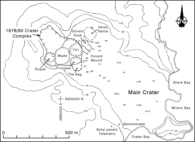 |
Figure 21. Sketch map of the main crater area of White Island showing crater and peg locations as of 19 January 1994. Contour elevations are in meters. Courtesy of IGNS. |
A deformation survey on 19 January suggested that local cooling, withdrawal of underlying brine fluids, and subterranean collapse were still operating beneath the Donald Mound area. Since 2 December 1993 an area centered W of Donald Mound-Donald Duck subsided at a rate similar to December 1992-December 1993 (4-5 mm/month). Possible deflation of ~3 mm SE of Donald Mound since last December, where inflation over the past year had averaged 1.7 mm/month, indicated that recent inferred heating in that area had stopped.
Lakes had reappeared in Wade and Royce craters by 29 January. A very sharp boundary could be seen within the Wade Crater lake. It was gray and steaming on the W side with a maximum temperature of 65°C, but the E side was greenish-yellow with a maximum temperature of 49°C. Steam discharges continued from the large vent at the W end of the crater, but noise levels were lower than on 15 January. A vigorously discharging superheated fumarole was observed on the N crater wall above the lake, but it was too small for a temperature measurement. Heavy rains on 4-5 February caused flash-flooding that stripped a large amount of ash from the surface and caused several landslides. A helicopter pilot noted that the lake level appeared 3-5 m higher, and that there was geysering and vigorous overturning in the lake.
A small eruption on 23 February was observed at about 1012, while scientists were in transit to the island. By 1018, the white, apparently ash-free steam plume had reached an altitude of 2 km (determined by an on-board altimeter), at which point the top of the plume was still vigorously convecting and ascending. Considering the temperature and ebullient nature of the crater lake, and because this was essentially a steam eruption, the vent in the crater lake was considered the most likely source for the eruption. A pulse of orange-brown ash was emitted from the 1978/90 Crater Complex at about 1155, followed by lesser amounts of pale gray ash for the rest of the afternoon. Because the vent area was almost totally obscured by steam, the source vent could not be determined.
The lake in Wade Crater again exhibited the two-tone coloration and similar temperatures as observed on 29 January, although the level was considerably higher. The turbid gray water in the W half of the lake appeared to descend beneath the comparatively suspension-free green water to the E. At least two sources of upwelling were apparent in the hotter gray water. Primary steam sources from the crater included the main fumarolic discharge from the NW part of Royce Crater, and increased discharges from fumaroles on the N wall immediately above the lake. Comments from a helicopter pilot indicated that this change in activity occurred after torrential rains about two weeks earlier. Combined noise levels from the fumaroles were moderate.
A small eruption near the location of a previous fumarole on Donald Mound had formed an elongate crater approximately 1 x 3 m in size and 50 cm deep. Two distinct low-temperature (98°C) discharges issued from this crater, one under high pressure. Preliminary analysis revealed fairly dry output gases with a high N2/Ar ratio of ~1,300. Temperatures at Noisy Nellie fumarole ... were in the 201-208°C range in January and February. Other fumaroles ranged from 98 to 109°C during the same period.
Geological Summary. The uninhabited Whakaari/White Island is the 2 x 2.4 km emergent summit of a 16 x 18 km submarine volcano in the Bay of Plenty about 50 km offshore of North Island. The island consists of two overlapping andesitic-to-dacitic stratovolcanoes. The SE side of the crater is open at sea level, with the recent activity centered about 1 km from the shore close to the rear crater wall. Volckner Rocks, sea stacks that are remnants of a lava dome, lie 5 km NW. Descriptions of volcanism since 1826 have included intermittent moderate phreatic, phreatomagmatic, and Strombolian eruptions; activity there also forms a prominent part of Maori legends. The formation of many new vents during the 19th and 20th centuries caused rapid changes in crater floor topography. Collapse of the crater wall in 1914 produced a debris avalanche that buried buildings and workers at a sulfur-mining project. Explosive activity in December 2019 took place while tourists were present, resulting in many fatalities. The official government name Whakaari/White Island is a combination of the full Maori name of Te Puia o Whakaari ("The Dramatic Volcano") and White Island (referencing the constant steam plume) given by Captain James Cook in 1769.
Information Contacts: B. Christenson and B. Scott, IGNS, Wairakei.