Report on Unzendake (Japan) — March 1994

Bulletin of the Global Volcanism Network, vol. 19, no. 3 (March 1994)
Managing Editor: Richard Wunderman.
Unzendake (Japan) Endogenous growth of lava dome; seismicity increases
Please cite this report as:
Global Volcanism Program, 1994. Report on Unzendake (Japan) (Wunderman, R., ed.). Bulletin of the Global Volcanism Network, 19:3. Smithsonian Institution. https://doi.org/10.5479/si.GVP.BGVN199403-282100
Unzendake
Japan
32.761°N, 130.299°E; summit elev. 1483 m
All times are local (unless otherwise noted)
Endogenous growth of the lava dome continued in March, with no new lava extrusion since late January. The eruption rate has remained at ~50,000 m3/day. Dome growth was toward the N, NW, and W; other parts of the dome remained stable. The spine-like cone that appeared near lobe 12 in February reached an elevation of 1,490 m by early April, 240 m above the crater floor. This cone moved NW in March and W in early April, settling just above the former Jigokuato Crater, from which the first lobe emerged in May 1991. The migrating cone created a depression 20-30 m deep behind it to the E, which was emitting volcanic gas (figure 68). The growing cone consisted of a massive-lava core surrounded by crumbled breccia. The core was composed of older brown lava that had solidified within the dome. Crest line measurements determined by theodolite from the UWS showed that the W part of the dome continued to uplift and move W at a rate of 2-3 m/day. As of 9 April, the peak had move ~80 m W and risen ~ 5-10 m from its location on 6 March.
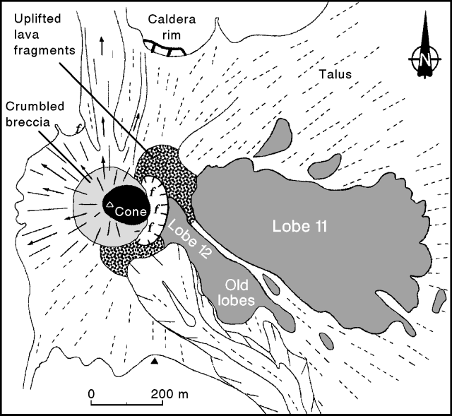 |
Figure 68. Sketch map of the lava dome at Unzen, early April 1994. Arrows indicate the main direction of pyroclastic flows and rockfalls. Solid and dashed lines represent slope dip directions of new and old talus deposits, respectively. Volcanic gas emission points are shown by "f" symbols. Courtesy of S. Nakada. |
Only 10 pyroclastic flows occurred in March, the lowest monthly total since they began in 1991. Some pyroclastic flows generated on 19 March by collapse of part of the dome traveled 1.5 km NNW. Residents living about 4 km from the summit in this direction are not staying in their homes at night. These flows went N because the caldera floor in that direction has now been completely filled by talus. Pyroclastic-flow deposits were
Rockfalls mainly went in the direction of the moving cone, advancing the talus front NW and W at a rate of 2-3 m/day. There is now a thick cover of talus on the Byobu-iwa craters, from which phreatic eruptions took place in February-May 1991. Rockfalls also forced seismic and GPS stations of the SEVO to repeatedly move farther away. Many mirrors installed for EDM measurements near the dome by the GSJ have been destroyed.
Strong deformation extended NW and W of the dome for 50-100 m away from the talus front. The ground had a wavy surface and had been uplifted as high as a few tens of meters. Many open cracks, up to 1 m wide, were radially oriented towards the growing cone; smaller cracks had various orientations. This ground deformation, which began in late January, had ceased by the end of March. EDM measurements revealed that the distance between a point immediately below the dome and a point on the N flank had shortened by about 30 m during February and March.
Microearthquakes increased to a total of 5,110 in March, compared to 1,726 in February. After 20 March, > 200 events/day were recorded.
Geological Summary. The massive Unzendake volcanic complex comprises much of the Shimabara Peninsula east of the city of Nagasaki. An E-W graben, 30-40 km long, extends across the peninsula. Three large stratovolcanoes with complex structures, Kinugasa on the north, Fugen-dake at the east-center, and Kusenbu on the south, form topographic highs on the broad peninsula. Fugendake and Mayuyama volcanoes in the east-central portion of the andesitic-to-dacitic volcanic complex have been active during the Holocene. The Mayuyama lava dome complex, located along the eastern coast west of Shimabara City, formed about 4000 years ago and was the source of a devastating 1792 CE debris avalanche and tsunami. Historical eruptive activity has been restricted to the summit and flanks of Fugendake. The latest activity during 1990-95 formed a lava dome at the summit, accompanied by pyroclastic flows that caused fatalities and damaged populated areas near Shimabara City.
Information Contacts: JMA; S. Nakada, Kyushu Univ.