Report on Kilauea (United States) — March 1994

Bulletin of the Global Volcanism Network, vol. 19, no. 3 (March 1994)
Managing Editor: Richard Wunderman.
Kilauea (United States) New lava flows, bench collapse, and postulated water entry into lava tubes
Please cite this report as:
Global Volcanism Program, 1994. Report on Kilauea (United States) (Wunderman, R., ed.). Bulletin of the Global Volcanism Network, 19:3. Smithsonian Institution. https://doi.org/10.5479/si.GVP.BGVN199403-332010
Kilauea
United States
19.421°N, 155.287°W; summit elev. 1222 m
All times are local (unless otherwise noted)
In March . . . E-51 and E-53 vents continued to erupt fluid tholeiitic lavas that traveled through tubes and plunged into the ocean (figures 94 and 95). On 2 March, half of the newly formed W Kamoamoa bench collapsed. Spectacular explosions followed (visible from the Chain of Craters road), which deposited spatter over an area extending 280 m along the coast and 35 m inland.
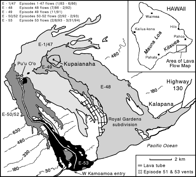 |
Figure 94. Map of the recent lava flows from Kīlauea's east rift zone, March 1994. Contours are in meters and the contour interval is approximately 150 m. Labeled features include lava flows identified by episode, active vents, and the Pu`u `O`o lava pond. Courtesy of T. Mattox, HVO. |
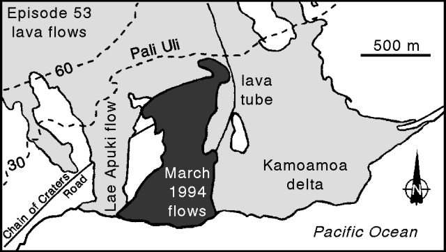 |
Figure 95. Detail of Hawaii coastline (Kamoamoa delta) showing the March 1994 lava flows from Kīlauea. Contours are in meters. Courtesy of T. Mattox, HVO. |
Lava stopped entering the ocean the next day, but by 1100 on 3 March, a flow escaped from a weak point in a tube at the base of a fault scarp (Pali Uli, figure 95); by 1153 the flow reached the coast. Explosions rapidly built a 6-m-high littoral cone on the bench. By 1200 on 5 March the rate of discharge decreased, leading to a lull in the eruptions. The rate of discharge picked up again on 8 March and continued through the next evening. These post-lull eruptions were accompanied by particularly large steam plumes, and they contained abundant spatter derived from broken bubble-walls, including some "Limu o Pele" (thin flakes of basaltic glass).
The large steam plumes in the post-lull eruptions presumably came about because seawater invaded the unoccupied tube system during the interval with low discharge. When lava reentered the tubes, contact with seawater lead to bubble-rich explosions.
Activity quieted by 10 March, and 3 days later lava again stopped entering the ocean. Activity resumed on 14 March when lava flows escaped at the 610-m and 274-m elevations. Lava continued to escape from the ~610-m elevation (the top of the cliff area called Pulama pali), but in the days that followed lava flows broke out of the tube system at progressively lower elevations. Lava escaped from the tube system just below Pali Uli on 15 March; on the following day it flowed into the ocean. The active flow front at the ocean (figure 95) wrapped around existing littoral cones, leaving their tops as prominent landmarks. By the end of the month, at least four tubes delivered lava to the active bench.
The surface of the Pu`u `O`o pond was 90-95 m below the level of the spillway rim during March. The pond's surface was not stagnant, it circulated with upwelling in the center moving outward.
During March the east rift zone continued to produce eruption tremor with fluctuating amplitude, sustained highs interrupted by nearly background levels ("banded tremor"). The last report on seismicity, 29 March, noted that after 27 March sustained tremor sometimes rose to 3x background. The number of microearthquakes was low beneath Kīlauea's summit, and it ranged from low to average along the east rift zone. Shallow, long-period earthquakes were abundant in these areas on both 15 March (200 events) and 16 March (84 events).
Geological Summary. Kilauea overlaps the E flank of the massive Mauna Loa shield volcano in the island of Hawaii. Eruptions are prominent in Polynesian legends; written documentation since 1820 records frequent summit and flank lava flow eruptions interspersed with periods of long-term lava lake activity at Halemaumau crater in the summit caldera until 1924. The 3 x 5 km caldera was formed in several stages about 1,500 years ago and during the 18th century; eruptions have also originated from the lengthy East and Southwest rift zones, which extend to the ocean in both directions. About 90% of the surface of the basaltic shield volcano is formed of lava flows less than about 1,100 years old; 70% of the surface is younger than 600 years. The long-term eruption from the East rift zone between 1983 and 2018 produced lava flows covering more than 100 km2, destroyed hundreds of houses, and added new coastline.
Information Contacts: T. Mattox, P. Okubo, and C. Heliker, HVO.