Report on Rincon de la Vieja (Costa Rica) — March 1994
Bulletin of the Global Volcanism Network, vol. 19, no. 3 (March 1994)
Managing Editor: Richard Wunderman.
Rincon de la Vieja (Costa Rica) Subaqueous degassing; fractures surrounding SE crater rim
Please cite this report as:
Global Volcanism Program, 1994. Report on Rincon de la Vieja (Costa Rica) (Wunderman, R., ed.). Bulletin of the Global Volcanism Network, 19:3. Smithsonian Institution. https://doi.org/10.5479/si.GVP.BGVN199403-345020
Rincon de la Vieja
Costa Rica
10.83°N, 85.324°W; summit elev. 1916 m
All times are local (unless otherwise noted)
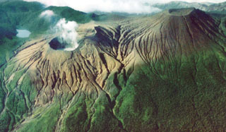
During March, Rincón de la Vieja continued fumarolic and seismic activity. The crater lake, which was 40 cm below the level seen in June 1993, had a temperature of 36°C. The lake had a clear gray color, although a fog of condensed gases hovering over the lake hampered visual observations. Visitors noted that vigorous, noisy fumaroles in the E crater wall produced enough sulfurous fumes to provoke coughing and irritate the eyes and skin. Fumes have also injured the already sparse vegetation adjacent to the active crater.
ICE researchers reported "sporadic and intermittent bubbling events (up to several meters in height and diameter) rising up from the center and SE portions of the warm lake, producing strong waves and noise, and giving a muddy-gray color to the lake." They also saw new, open fractures surrounding the SE crater rim.
In the interval February-March 1993, Rincón's seismic station registered an increase in events of low frequency (0.5-1.3 Hz) with durations [of] 25-150 seconds (figure 9). When previously seismically active, as in January and September 1993, both high- and low-frequency signals were common.
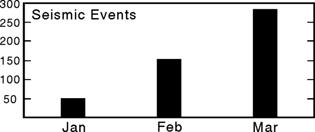 |
Figure 9. Seismic events at Rincón de la Vieja received at station RIN3, 5 km SW of the active crater, January-March 1994. Courtesy of OVSICORI. |
Geological Summary. Rincón de la Vieja, the largest volcano in NW Costa Rica, is a remote volcanic complex in the Guanacaste Range. The volcano consists of an elongated, arcuate NW-SE-trending ridge constructed within the 15-km-wide early Pleistocene Guachipelín caldera, whose rim is exposed on the south side. Sometimes known as the "Colossus of Guanacaste," it has an estimated volume of 130 km3 and contains at least nine major eruptive centers. Activity has migrated to the SE, where the youngest-looking craters are located. The twin cone of Santa María volcano, the highest peak of the complex, is located at the eastern end of a smaller, 5-km-wide caldera and has a 500-m-wide crater. A Plinian eruption producing the 0.25 km3 Río Blanca tephra about 3,500 years ago was the last major magmatic eruption. All subsequent eruptions, including numerous historical eruptions possibly dating back to the 16th century, have been from the prominent active crater containing a 500-m-wide acid lake located ENE of Von Seebach crater.
Information Contacts: Gerardo J. Soto, Guillermo E. Alvarado, and Francisco (Chico) Arias, ICE; E. Fernández, J. Barquero, R. Van der Laat, F. de Obaldia, T. Marino, V. Barboza, and R. Sáenz, OVSICORI.