Report on Kanaga (United States) — April 1994
Bulletin of the Global Volcanism Network, vol. 19, no. 4 (April 1994)
Managing Editor: Richard Wunderman.
Kanaga (United States) Minor steam and ash eruptions
Please cite this report as:
Global Volcanism Program, 1994. Report on Kanaga (United States) (Wunderman, R., ed.). Bulletin of the Global Volcanism Network, 19:4. Smithsonian Institution. https://doi.org/10.5479/si.GVP.BGVN199404-311110
Kanaga
United States
51.923°N, 177.168°W; summit elev. 1307 m
All times are local (unless otherwise noted)
Low-level steam and ash eruptions continued from mid-April through mid-May, although poor weather often obscured the volcano. Observers in Adak . . . reported seeing steam, and possibly minor ash, rising a few hundreds of meters above the volcano early during the week of 15-22 April. On 28 April, FWS personnel in Adak observed and photographed a gray ash cloud erupting from the summit crater. The cloud did not rise much above the summit before strong winds carried the plume to the SW. On 5 May, U.S. Navy personnel in Adak observed steam clouds from the summit crater during a short break in the weather. Early in the week of 6-13 May, U.S. Navy and FWS personnel observed steam clouds rising from the summit crater to an estimated altitude of 1,800-2,400 m. They also observed a dark stripe extending down the SE flank from near the summit; a lack of steaming suggested that it was either a small mudflow or ash concentrated by snowmelt.
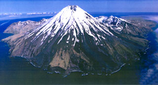
Geological Summary. Symmetrical Kanaga stratovolcano is situated within the Kanaton caldera at the northern tip of Kanaga Island. The caldera rim forms a 760-m-high arcuate ridge south and east of Kanaga; a lake occupies part of the SE caldera floor. The volume of subaerial dacitic tuff is smaller than would typically be associated with caldera collapse, and deposits of a massive submarine debris avalanche associated with edifice collapse extend nearly 30 km to the NNW. Several fresh lava flows from historical or late prehistorical time descend the flanks of Kanaga, in some cases to the sea. Historical eruptions, most of which are poorly documented, have been recorded since 1763. Kanaga is also noted petrologically for ultramafic inclusions within an outcrop of alkaline basalt SW of the volcano. Fumarolic activity occurs in a circular, 200-m-wide, 60-m-deep summit crater and produces vapor plumes sometimes seen on clear days from Adak, 50 km to the east.
Information Contacts: AVO.