Report on Ijen (Indonesia) — May 1994
Bulletin of the Global Volcanism Network, vol. 19, no. 5 (May 1994)
Managing Editor: Richard Wunderman.
Ijen (Indonesia) Additional details about July-August 1993 phreatic activity
Please cite this report as:
Global Volcanism Program, 1994. Report on Ijen (Indonesia) (Wunderman, R., ed.). Bulletin of the Global Volcanism Network, 19:5. Smithsonian Institution. https://doi.org/10.5479/si.GVP.BGVN199405-263350
Ijen
Indonesia
8.058°S, 114.242°E; summit elev. 2769 m
All times are local (unless otherwise noted)
Phreatic eruptions in July 1993 were preceded by increasing seismicity, but caused no damage. The following report, summarized from . . . VSI (1993a and b), provides additional details about this activity.
The number of volcanic earthquakes started to increase at the end of June 1993. Continuous tremor recorded on 21 June had a maximum amplitude of 0.5-2 mm. The next day, 37 shallow volcanic earthquakes were detected. Tremor amplitude gradually increased from 23 to 30 June. On 26 June, 4 deep volcanic earthquakes occurred. The number of volcanic earthquakes increased until 1 July when a gradual decrease began. However, by 1 July the maximum tremor amplitude was 7-10 mm. Because of the seismic activity, a warning was issued to the local population, to tourists, and to workers at the sulfur mine, saying that the area around the crater was closed.
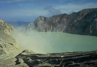
Water temperature in the crater lake on 2 July was normal (36°C). The lake water was a pale green color, and the surface was covered by dense white vapor to a height of 10 m. Yellowish white vapor was being emitted from the solfatara field, and a very strong sulfur odor could be smelled.
A phreatic eruption at 0845 on 3 July from the center of the crater lake was accompanied by loud eruption sounds. The cloud released from the lake was 10-15 m high and 60-80 m in diameter. Lake water became brownish green, and the surface was dark. Two more phreatic eruptions the next morning (at 0835 and 1045) were smaller than the first; the early morning cloud rose 8-10 m, and no sounds were heard during the second of the 4 July eruptions. Rockfalls occurred at 1000 on 5 July from the S inner crater wall. A rumbling noise indicative of another phreatic eruption was heard at 0215 on 7 July at the sulfur weighing station, ~750 m from the crater.
During the period from 8 to 31 July, seismicity was variable, but there were no phreatic eruptions. Maximum tremor amplitude decreased to 0.5-4 mm. The number of deep volcanic earthquakes fluctuated in the 1-13 events/day range while shallow volcanic earthquakes occurred at a rate of 3-22/day. The temperature of water in the crater lake rose from 39 to 40°C.
Two phreatic eruptions occurred on 1 August starting at 1635; the sound could be heard at the sulfur weighing station. These eruptions were preceded by a tectonic earthquake with an amplitude >46 mm. There were no reports of injuries during any of the phreatic eruptions in July or August.
Seismic activity gradually decreased during 2-21 August when 0-2 deep and 5-23 shallow volcanic earthquakes were recorded each day. Crater lake water temperature through most of August was 39-41°C, and the pH was 1. Maximum tremor amplitude was 1-6 mm until 22 August when tremor was no longer continuous and maximum amplitude decreased to 1 mm. Between 22 August and 9 September deep volcanic earthquakes were recorded at a rate of 1-2/day; shallow events varied from 2 to 17/day. By 10 September, seismic data and visual observations indicated that the volcano had returned to a "normal" level of activity.
References. Volcanological Survey of Indonesia, 1993a, Ijen Volcano: Journal of Volcanic Activity in Indonesia, v. 1, no. 1/2, p. 14.
Volcanological Survey of Indonesia, 1993b, Ijen Volcano: Journal of Volcanic Activity in Indonesia, v. 1, no. 3/4, p. 8-12.
Geological Summary. The Ijen volcano complex at the eastern end of Java consists of a group of small stratovolcanoes constructed within the 20-km-wide Ijen (Kendeng) caldera. The north caldera wall forms a prominent arcuate ridge, but elsewhere the rim was buried by post-caldera volcanoes, including Gunung Merapi, which forms the high point of the complex. Immediately west of the Gunung Merapi stratovolcano is the historically active Kawah Ijen crater, which contains a nearly 1-km-wide, turquoise-colored, acid lake. Kawah Ijen is the site of a labor-intensive mining operation in which baskets of sulfur are hand-carried from the crater floor. Many other post-caldera cones and craters are located within the caldera or along its rim. The largest concentration of cones forms an E-W zone across the southern side of the caldera. Coffee plantations cover much of the caldera floor; nearby waterfalls and hot springs are tourist destinations.
Information Contacts: W. Tjetjep, VSI; BOM Darwin, Australia; S. Matthews, Univ of Bristol; UPI; ANS.

