Report on Unzendake (Japan) — May 1994

Bulletin of the Global Volcanism Network, vol. 19, no. 5 (May 1994)
Managing Editor: Richard Wunderman.
Unzendake (Japan) Endogenous growth continues; seismicity declines
Please cite this report as:
Global Volcanism Program, 1994. Report on Unzendake (Japan) (Wunderman, R., ed.). Bulletin of the Global Volcanism Network, 19:5. Smithsonian Institution. https://doi.org/10.5479/si.GVP.BGVN199405-282100
Unzendake
Japan
32.761°N, 130.299°E; summit elev. 1483 m
All times are local (unless otherwise noted)
Endogenous dome growth to the W and NW . . . had ceased by the end of April. However, the dome began to grow in a SW direction in mid-May. This SW growth continued through at least mid-June at a rate of 1-2 m/day. EDM measurements taken by the GSJ revealed that a line on the N flank had shortened between January and April, implying that inflation of the entire mountain had ceased by the end of April, but the same line showed elongation in May.
Elevations of lava-dome peaks have steadily increased since the eruption began (figure 71). The highest peak in early June was 250 m above the level of the Jigokuato crater floor. Peaks were commonly formed just above the magma-supply vent during both exogenous and endogenous growth, but no lava extrusion has taken place above 1,420 m elevation.
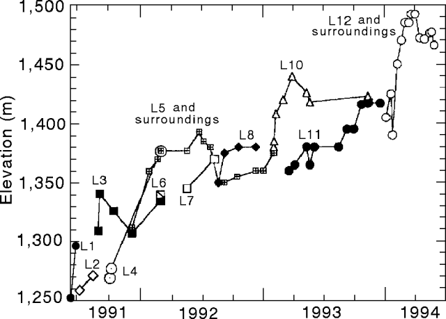 |
Figure 71. Elevation of lava-dome peaks at Unzen, 20 May 1991-June 1994. The highest peak as of June 1994 is lobe 12 (L12); base elevation shown (1,250 m) is for the Jigokuato crater. Different lobes are indicated by symbols and lobe numbers. All measurements were made using a theodolite and mirror-less laser distance meter by geologists from the Joint University Research Group. Courtesy of S. Nakada. |
A time plot of the eruption rate shows two pulses of magma during the current eruption (figure 72). The first pulse (May 1991-December 1992) was characterized mainly by exogenous growth. The second pulse (December 1992), which started with lobe 9, was dominated by exogenous growth early (first half of the pulse), but then changed to endogenous growth. The volume of magma erupted during the first pulse, 1.3 x 10⁸ m3, is roughly double that erupted during the second pulse (0.6 x 10⁸ m3). Total volume of the lava dome, based on analysis of aerial photos by the GSJ, was 90 x 106 m3 as of 9 April. The lava extrusion rate between 7 February and 9 April was 60,000 m3/day (figure 72). The eruption rate declined in May to3/day as determined by the Joint University Research Group. No fresh lava has been extruded onto the dome surface since February.
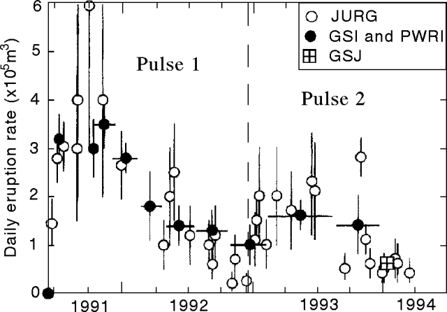 |
Figure 72. Daily eruption rate at Unzen, 20 May 1991-June 1994, showing two distinct pulses of magma-supply. Eruption rates were estimated by the Joint University Research Group (JURG) using photographs from daily helicopter inspections and theodolite surveys. Only aerial photographs were used by the Geographical Survey Institute (GSI), the Public Works Research Institute (PWRI), and the Geological Survey of Japan (GSJ) to calculate the volume change of eruption products. Courtesy of S. Nakada. |
Most pyroclastic flows traveled down the SW and SE flanks, only rarely did they descend N of the dome. The longest pyroclastic flow of the month went 2.5 km on 3 May. Pyroclastic flows are detected seismically at a station ~1 km WSW of the dome. Real-time monitoring of both the dome and pyroclastic flows is conducted from the Unzen Weather Station using four visible and thermal infrared video cameras. Microearthquakes beneath the dome averaged >100/day. The total of 3,171 earthquakes in May continues the decline in seismicity . . . .
The Coordination Committee for Prediction of Volcanic Eruption had a meeting on 3 June. A statement issued after the meeting noted that both the lava dome and the entire volcanic edifice were very unstable, and that pyroclastic flows generated by collapse of lava might occur despite the decline in lava extrusion. As of 31 May, 3,307 people remained evacuated.
Geological Summary. The massive Unzendake volcanic complex comprises much of the Shimabara Peninsula east of the city of Nagasaki. An E-W graben, 30-40 km long, extends across the peninsula. Three large stratovolcanoes with complex structures, Kinugasa on the north, Fugen-dake at the east-center, and Kusenbu on the south, form topographic highs on the broad peninsula. Fugendake and Mayuyama volcanoes in the east-central portion of the andesitic-to-dacitic volcanic complex have been active during the Holocene. The Mayuyama lava dome complex, located along the eastern coast west of Shimabara City, formed about 4000 years ago and was the source of a devastating 1792 CE debris avalanche and tsunami. Historical eruptive activity has been restricted to the summit and flanks of Fugendake. The latest activity during 1990-95 formed a lava dome at the summit, accompanied by pyroclastic flows that caused fatalities and damaged populated areas near Shimabara City.
Information Contacts: S. Nakada, Kyushu Univ; JMA.