Report on Karkar (Papua New Guinea) — June 1994

Bulletin of the Global Volcanism Network, vol. 19, no. 6 (June 1994)
Managing Editor: Richard Wunderman.
Karkar (Papua New Guinea) Sharp increase in seismicity from mid-May to mid-June
Please cite this report as:
Global Volcanism Program, 1994. Report on Karkar (Papua New Guinea) (Wunderman, R., ed.). Bulletin of the Global Volcanism Network, 19:6. Smithsonian Institution. https://doi.org/10.5479/si.GVP.BGVN199406-251030
Karkar
Papua New Guinea
4.647°S, 145.976°E; summit elev. 1839 m
All times are local (unless otherwise noted)
"Minor unrest in May-June affected the pattern of activity recorded at Karkar since the end of its last eruption in 1979. However, there was no visual change in the condition of the caldera (which is now mostly covered with vegetation), and no significant change in the temperatures (<100°C) of the thermal areas remaining on the central cone, Bagiai.
"The local seismograph . . . recorded a large number of emergent low-frequency earthquakes starting on 17 May. This activity was highest during 22-25 May, with >30 events/day, and decayed progressively until mid-June (figure 3). Records from two portable seismographs, deployed in the summit caldera and on the NW flank on 1-2 June, indicated that these events originated from the summit area.
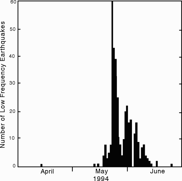 |
Figure 3. Low-frequency earthquakes at Karkar, April-June 1994. Courtesy of RVO. |
"Re-occupation of the leveling and tilt arrays on the floor of the summit caldera showed an interruption in the steady deflationary pattern recorded since 1983 (figure 4). The stations closest to the sites of eruptions in 1974, 1975, and 1979 had been subsiding at a rate of ~10 mm/year. The subsidence appears to have ceased sometime since the previous survey, in November 1993, or to have reversed on the occasion of this recent swarm."
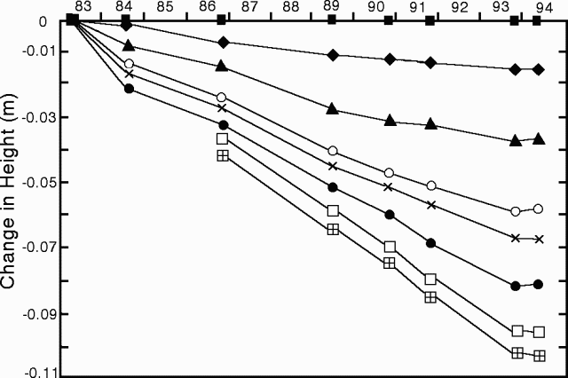 |
Figure 4. Leveling on the inner summit caldera floor at Karkar, 1983-94. Symbols represent benchmarks on a radial leveling line on the E caldera floor. The station indicated by a solid square is near the caldera wall; the open square with a cross represents the station nearest to the center of the caldera. Courtesy of RVO. |
Geological Summary. Karkar is a 19 x 25 km forest-covered island that is truncated by two nested summit calderas. The 5.5 km outer caldera was formed during one or more eruptions, the last of which occurred 9,000 years ago. The steep-walled 300-m-deep, 3.2 km diameter, inner caldera was formed sometime between 1,500 and 800 years ago. Cones are present on the N and S flanks of this basaltic-to-andesitic volcano; a linear array of small cones extends from the northern rim of the outer caldera nearly to the coast. Recorded eruptions date back to 1643 from Bagiai, a pyroclastic cone constructed within the inner caldera, the floor of which is covered by young, mostly unvegetated andesitic lava flows.
Information Contacts: D. Lolok, R. Stewart, I. Itikarai, P. de Saint-Ours, and C. McKee, RVO.