Report on Kanaga (United States) — June 1994
Bulletin of the Global Volcanism Network, vol. 19, no. 6 (June 1994)
Managing Editor: Richard Wunderman.
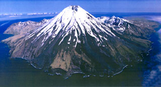
Kanaga (United States) Incandescent material observed cascading down the NW flank
Please cite this report as:
Global Volcanism Program, 1994. Report on Kanaga (United States) (Wunderman, R., ed.). Bulletin of the Global Volcanism Network, 19:6. Smithsonian Institution. https://doi.org/10.5479/si.GVP.BGVN199406-311110
Kanaga
United States
51.923°N, 177.168°W; summit elev. 1307 m
All times are local (unless otherwise noted)
Several pilot reports received by the FAA during 10-17 June indicated steam plumes carrying small amounts of ash that reached 1.5-2 km altitude and drifted generally SE. Subsequent analysis of AVHRR satellite images, however, could not confirm the presence of ash. Poor weather precluded any ground observations from Adak . . . .
FWS personnel aboard the RV Tiglax observed continuing eruptive activity during the early morning hours (0145 -0245) of 20 June. From their location several hundred meters off the NW shoreline of Kanaga Island, crew members observed two distinct "streams" of incandescent material cascading down the NW flank, but were unsure if any debris reached the ocean. The upper flanks and summit were obscured by steam, and the exact origin of the incandescent streams could not be determined. Analysis of satellite images from near the time of these observations was hampered by cloud cover.
Geological Summary. Symmetrical Kanaga stratovolcano is situated within the Kanaton caldera at the northern tip of Kanaga Island. The caldera rim forms a 760-m-high arcuate ridge south and east of Kanaga; a lake occupies part of the SE caldera floor. The volume of subaerial dacitic tuff is smaller than would typically be associated with caldera collapse, and deposits of a massive submarine debris avalanche associated with edifice collapse extend nearly 30 km to the NNW. Several fresh lava flows from historical or late prehistorical time descend the flanks of Kanaga, in some cases to the sea. Historical eruptions, most of which are poorly documented, have been recorded since 1763. Kanaga is also noted petrologically for ultramafic inclusions within an outcrop of alkaline basalt SW of the volcano. Fumarolic activity occurs in a circular, 200-m-wide, 60-m-deep summit crater and produces vapor plumes sometimes seen on clear days from Adak, 50 km to the east.
Information Contacts: AVO.