Report on Batur (Indonesia) — July 1994
Bulletin of the Global Volcanism Network, vol. 19, no. 7 (July 1994)
Managing Editor: Richard Wunderman.
Batur (Indonesia) First significant eruptive activity in 18 years leads to ashfall 6 km WSW of the summit
Please cite this report as:
Global Volcanism Program, 1994. Report on Batur (Indonesia) (Wunderman, R., ed.). Bulletin of the Global Volcanism Network, 19:7. Smithsonian Institution. https://doi.org/10.5479/si.GVP.BGVN199407-264010
Batur
Indonesia
8.2403°S, 115.3775°E; summit elev. 1711 m
All times are local (unless otherwise noted)
Beginning on 4 August, the daily number of A-type volcanic earthquakes increased to 14; two days later 125 events were registered. An eruption on 7 August from the E part of the summit, Batur Crater III, caused ashfall as far as ~6 km WSW (figure 1). Ash covered Kintamani on the caldera rim, one of Bali's famous tourist attractions. Incandescent lava fragments and black smoke were ejected to heights of 300 m. None of the larger lava fragments fell outside of the active crater. News reports indicated that the eruption generated 960 explosions through 11 August. Volcanic tremor recorded by the VSI on 13 August had a maximum amplitude of 4.5 mm, but was increasing. By 14 August, when lava reached the surface, the tremor amplitude was 23 mm.
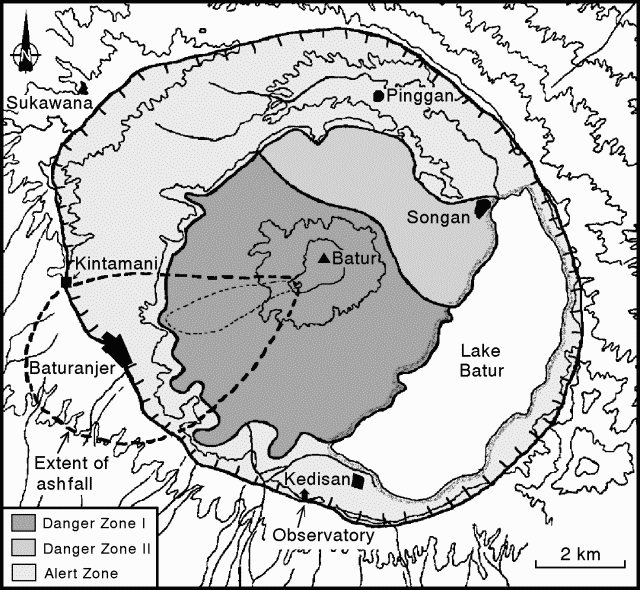 |
Figure 1. Map of the Batur caldera, showing hazard zones, selected towns, and extent of ashfall from the eruption that began on 7 Aug 1994. The inner caldera is not shown, but includes most of danger zones I and II. Courtesy of VSI. |
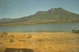
As of 18 August, no evacuations from the area around the . . . volcano had taken place. About 180,000 people live in Bangli Regency, but only ~500 live in what a spokesman called the "critical region." Batur was declared off-limits for climbers on 7 August, and local villagers were put on alert. An official at a monitoring center said tourists who evaded guards and climbed the mountain were taking large risks. According to press reports, the eruptions have not reduced the number of visitors to the popular resort island; Batur's crater attracts ~300 people every day. Many observe the volcanic activity from Kintamani, on the crater rim (figure 1).
Geological Summary. The historically active Batur is located at the center of two concentric calderas NW of Agung volcano. The outer 10 x 13.5 km caldera was formed during eruption of the Bali (or Ubud) Ignimbrite about 29,300 years ago and now contains a caldera lake on its SE side, opposite the Gunung Abang cone, the topographic high of the complex. The inner 6.4 x 9.4 km caldera was formed about 20,150 years ago during eruption of the Gunungkawi Ignimbrite. The SE wall of the inner caldera lies beneath Lake Batur; Batur cone has been constructed within the inner caldera to a height above the outer caldera rim. The Batur stratovolcano has produced vents over much of the inner caldera, but a NE-SW fissure system has localized the Batur I, II, and III craters along the summit ridge. Recorded eruptions have been characterized by mild-to-moderate explosive activity sometimes accompanied by lava emission. Basaltic lava flows from both summit and flank vents have reached the caldera floor and the shores of Lake Batur in historical time.
Information Contacts: VSI; AP; Reuters; UPI; ANS; D. Shackleford, Fullerton CA, USA.