Report on Unzendake (Japan) — July 1994

Bulletin of the Global Volcanism Network, vol. 19, no. 7 (July 1994)
Managing Editor: Richard Wunderman.
Unzendake (Japan) Lava lobe 13 grows endogenously but then nearly stops growing in late-July
Please cite this report as:
Global Volcanism Program, 1994. Report on Unzendake (Japan) (Wunderman, R., ed.). Bulletin of the Global Volcanism Network, 19:7. Smithsonian Institution. https://doi.org/10.5479/si.GVP.BGVN199407-282100
Unzendake
Japan
32.761°N, 130.299°E; summit elev. 1483 m
All times are local (unless otherwise noted)
Lobe 13 . . . grew endogenously at slow rates until late-July. Its final size was ~80 m long, 70 m wide, and 30 m high; it lies hidden behind the roughly 10x longer lobe 11, which forms the prominent bulge on figures 73 and 74.
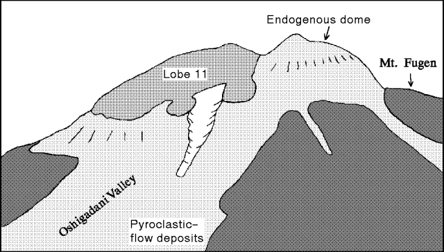 |
Figure 73. Sketch of the Unzen lava done showing features of the 22 July photograph (figure 74); view is roughly [from] the N. Vegetated surfaces are shown in black, undifferentiated dome, talus, pyroclastic-flow, and other deposits shown lightly shaded. Courtesy of S. Nakada. |
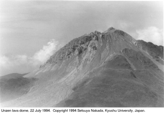 |
Figure 74. Photograph of the lava dome at Unzen, 22 July 1994. Taken from a helicopter looking [from] approximately N. Courtesy of S. Nakada. |
In Unzen's summit area, the endogenous dome developed three E-W trending ridges along its top. The highest (central) ridge uplifted in early-July between two other ridges. The central ridge and a N ridge moved to the N at a rate of ~2 m/day during July, leaving behind the S ridge and increasing the width of a graben between them. The central ridge also rose vertically at a rate of <1 m/day. The E part of the central ridge consisted of brown-colored massive lava that was rounded, convex upward, and relatively smooth. The ridge was composed of massive lava squeezed from the interior of the dome, an effect also seen in April. When the lava reached the top of the ridge it broke and collapsed.
The ridges stopped moving N at the end of July. Occasionally there were small, low-density rockfalls to the SW in early- to mid-August. Owing to fragmentation, the massive lava of the central ridges decreased its height by ~20 m during the first two weeks in August, and at the same time the talus slope hardly advanced in any direction. These observations imply that for this two-week period in August an extremely low eruption rate (estimated at 4m3/day) prevailed.
During mid-July to early-August a continuous rain of N-directed rockfalls occurred when the N ridge became exposed at the cliff top. These rockfalls transformed into small pyroclastic flows, generally with run-out distances under 1 km. Pyroclastic flows were detected seismically at a station 1 km WSW of the dome and real-time monitoring of the dome was accomplished by four sets of visible and thermal infrared video cameras. During July this system detected 44 pyroclastic flows.
During most of July, microearthquakes beneath the dome generally took place <80 times a day. The total number of earthquakes in July was 2,488, roughly a 20% drop from the previous two months.
EDM by the JMA and the GSJ found that during late-June through mid-July the radial distance to one reflector on Unzen's N flank shortened rapidly, by tens of centimeters/day. The lack of confirmation from other reflectors suggested that the area in motion was of limited size.
Geological Summary. The massive Unzendake volcanic complex comprises much of the Shimabara Peninsula east of the city of Nagasaki. An E-W graben, 30-40 km long, extends across the peninsula. Three large stratovolcanoes with complex structures, Kinugasa on the north, Fugen-dake at the east-center, and Kusenbu on the south, form topographic highs on the broad peninsula. Fugendake and Mayuyama volcanoes in the east-central portion of the andesitic-to-dacitic volcanic complex have been active during the Holocene. The Mayuyama lava dome complex, located along the eastern coast west of Shimabara City, formed about 4000 years ago and was the source of a devastating 1792 CE debris avalanche and tsunami. Historical eruptive activity has been restricted to the summit and flanks of Fugendake. The latest activity during 1990-95 formed a lava dome at the summit, accompanied by pyroclastic flows that caused fatalities and damaged populated areas near Shimabara City.
Information Contacts: S. Nakada, Kyushu Univ; JMA.