Report on Telica (Nicaragua) — July 1994
Bulletin of the Global Volcanism Network, vol. 19, no. 7 (July 1994)
Managing Editor: Richard Wunderman.
Telica (Nicaragua) Explosive eruption causes ashfall >12 km SW of the summit
Please cite this report as:
Global Volcanism Program, 1994. Report on Telica (Nicaragua) (Wunderman, R., ed.). Bulletin of the Global Volcanism Network, 19:7. Smithsonian Institution. https://doi.org/10.5479/si.GVP.BGVN199407-344040
Telica
Nicaragua
12.606°N, 86.84°W; summit elev. 1036 m
All times are local (unless otherwise noted)
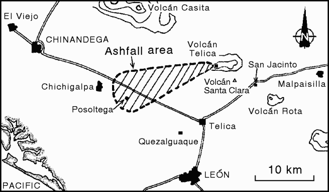
An eruption on 31 July produced a gas-and-ash column that rose ~800 m above the 1,060-m-high summit. Ashfall was reported SW of the volcano (figure 6). Phreatic activity continued until 12 August with gas emission and minor ash explosions. Seismicity has been recorded continuously since December 1993, when a permanent telemetered seismic station (TELN: short-period, vertical-component) was installed ~500 m E of the active crater rim (figure 7). Also since December 1993, the Instituto Nicaragüense de Estudios Territoriales (INETER) has collaborated with the government, local authorities, civil defense, and the media, to educate the population about the situation at the volcano. Due to the relatively low magnitude of this eruption, it was not necessary to carry out the prepared evacuation plans.
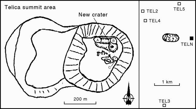 |
Figure 7. Sketch map of the summit area at Telica, showing locations of crater fumaroles (left) and seismic stations (right). Courtesy of INETER. |
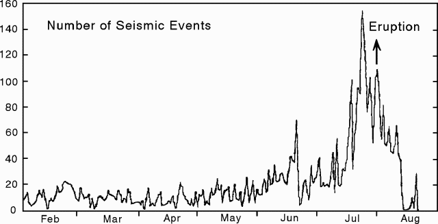
A seismic event on 15 June 1994 was recorded by several stations of the Nicaraguan seismic network, up to distances of ~40 km from Telica. This event at a depth of 6 km had a maximum magnitude of 2.1. The 31 July eruption was preceded by a steady increase in seismicity during 15-25 July (figure 8), recorded by station TELN. Seismicity had increased from25 events/day at the end of May. By the end of July there were up to 150 events/day.
Crater and fumarole observations, March-June 1994. Beginning on 3 June, scientists from Florida International Univ (FIU) and INETER spent 15 days at Telica as part of an ongoing investigation to determine the areal extent and intensity of degassing, and the role of structural controls on degassing from the volcanic complex. A lacustrine deposit was observed in March at the S end of the crater, and a small, muddy brown lake was visible in May-June. All observations were made from the NE rim, where jetting sounds were clearly audible. Sulfur-rich steam from the crater sometimes moved down the slopes of the volcano, filling the NW valley with high concentrations of SO2; sulfur odor could occasionally be smelled on the NE slope. Residents on the flanks of the volcano stated that the activity was not unusual for this time of the year.
Fumarole temperatures near station TELN were in the 81-86°C range, similar to temperatures in September 1993 and March 1994. A low-temperature fumarole was discovered on the lower ESE slope of the ridge occupied by the seismic station. A data-logger recorded fumarole temperatures and barometric pressure for four days. Fumaroles near TELN and in the active crater exhibited increased flux since March. At times the crater fumaroles appeared to be emitting steam and gases in discrete clouds at intervals of several minutes. The most intense fumarole was in the upper NW corner of the crater (A on figure 7). Other fumaroles were observed in the lower NW corner, on the N, E, and SE crater walls, and in avalanche deposits on the S and SE parts of the crater floor. Fumarole A had temperatures of 150-160°C in July 1994 (figure 7). In the NE corner of the crater, fumarole B increased in temperature from 55°C in April to 174°C in July. Another fumarole area on the E side of the crater (C) had a temperature of 498°C in July, a significant increase from 246°C in 1990.
Eruptive activity. A relatively small explosive eruption at about 1645 on 31 July produced a gas-and-ash column that rose ~800 m above the summit. The light-gray ash cloud was driven SW by the wind, depositing about 2 mm of ash in the towns of Chichigalpa (20 km WSW), Quezalguaque (12.5 km SSW), and Posoltega (16 km SW) (figure 6). No seismic events were felt by residents near the volcano, but the sound of the explosion was heard at distances up to 10 km.
Following the 31 July eruption, phreatic activity continued in the next hours and days with varying intensity of gas emanation and ash expulsion. One of the strongest explosions, on 5 August, produced an ash column 1,200 m high. One phase of gas emission reached heights of 200-300 m above the crater rim. Gas also filled a valley W of the volcano with high concentrations of SO2, sometimes causing breathing problems for INETER scientists who traveled through the valley at a distance of ~2 km from the crater. Seismicity at shallow depths (~2 km) beneath the crater was recorded by TELN and four stations installed after the eruption began: telemetric stations TEL 2, 3, & 4, and local digital registration station TEL 5 (figure 7). The numerous weak events during the eruption were only recorded by the local seismic stations.
Chemical analyses of washed ash samples collected on different days indicated an increase of the SO42- and Cl- contents over time. Several very heavy rainfalls occurred during the eruptive period. Analyzed rainwater samples also showed high concentrations of SO42- with respect to Cl- and F2-, and a corresponding low pH level. Similar measurements two weeks before the eruption showed normal low concentrations of SO42- and Cl-.
Early eruption products consisted of very fine-grained, light-colored, blocky ash. INETER volcanologists believe that the ash was non-juvenile, and was ejected during phreatic or phreatomagmatic eruptions. Major explosions generally lasted for ~10-25 minutes. Early eruption columns were mostly white in color, and ranged from several hundred meters to 1,400 m above the vent. On 9 and 10 August, the ash was black, significantly darker than before, with correspondingly darker eruption plumes. The ash remained blocky and non-vesicular.On 10 August, 40-50 high-frequency seismic events were recorded, including one that lasted 4.5 hours. High-frequency events prior to 10 August occurred at a rate of ~70-90/day and were associated with more frequent explosions (10-20/day). The number of daily explosions also decreased to 6 on 10 August, including one major explosion that lasted for 16 minutes. An explosion at 1800 on 11 August generated a plume that rose 350 m, but only 16 high-frequency events were detected that day. On the early morning of 12 August one of the strongest explosions of this eruption occurred; activity then decreased throughout the day. By that evening the explosions had stopped and gas emanation and seismicity reached very low levels.
Seismicity had increased slightly by 16 August, five microseismic events were detected during 24 hours on 17-18 August, and on 20 August tremor lasted for 6.2 hours. However, no seismic events were detected on 21-22 August, and activity remained low as of 26 August.
On 23 August, Oto Matias (INSIVUMEH, Guatemala) arrived with a COSPEC instrument to assist INETER scientists in making SO2-flux measurements. Attempts to carry out COSPEC measurements of the SO2 concentration in the gas plume were made on 24 August, but low levels of gas emission and cloudy skies prevented good results.
Soil sampling. During three field surveys by FIU and INETER scientists in early June, >60 stations were deployed over 50 km2 to determine the concentration of radon (Rn), CO2, Hg, and He in soils. One identified anomaly had intensified between March and May/June 1994. This anomaly, ~750 m long and 250 m wide, surrounded the TELN seismic station. Along this anomaly, Hg values ranged from several tens of ppb to >2,900 ppb, He from 5,399 to 5,415 ppb, CO2 to 2.1 volume %, and Rn to 1,819 pico-Curies/liter.
San Jacinto Hot Springs. The village of San Jacinto, 9 km NE of the town of Telica and 2 km E of Santa Clara volcano, contains a field of boiling mudpots (BGVN 19:03). Soil samples for Hg and CO2 measurements were collected from the hydrothermal field in March and May/June 1994. The March samples contained CO2 concentrations up to 0.09 volume % and Hg from 6,710 to 21,512 ppb. The onset of the rainy season had resulted in an increase in both the size of the field and the steam flux since 9 March. Exploration for a new geothermal power plant was taking place approximately 250 m WNW.
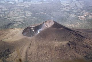
Historical activity. Telica is a composite volcano located 19 km N of León at the NW end of a large volcanic complex. Known historical activity dates from a strong eruption that occurred in 1527-29. Strong activity was also noted in 1685, 1740-43, and at least 7 times in the 20th century. During several eruptions ash has damaged agricultural crops. In February 1982 several strong explosions generated ash columns of 3.5 km height and the ashfall affected nearby towns. The most recent eruption of Telica in November 1987 included Strombolian-type activity.
Eruptions in pre-historical times produced ash deposits of 50 cm thickness or more within a radius of 50 km. A volcanic hazard map (figure 9) suggests that ashfall poses the greatest threat to the local population. Lava flows have occurred, but with low frequency, most recently ~1,000 years ago. The hazard zone for pyroclastic eruptions lies within ~2 km of the crater. Lahars have occurred as a result of very strong eruptions during the rainy season.
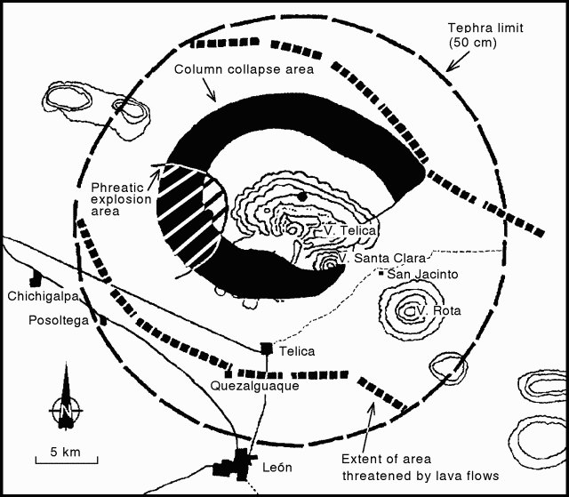 |
Figure 9. Volcanic hazards map of Telica. Hazard zones are shown for ashfall and tephra, lava flows, and column collapse. Courtesy of INETER. |
Geological Summary. Telica, one of Nicaragua's most active volcanoes, has erupted frequently since the beginning of the Spanish era. This volcano group consists of several interlocking cones and vents with a general NW alignment. Sixteenth-century eruptions were reported at symmetrical Santa Clara volcano at the SW end of the group. However, its eroded and breached crater has been covered by forests throughout historical time, and these eruptions may have originated from Telica, whose upper slopes in contrast are unvegetated. The steep-sided cone of Telica is truncated by a 700-m-wide double crater; the southern crater, the source of recent eruptions, is 120 m deep. El Liston, immediately E, has several nested craters. The fumaroles and boiling mudpots of Hervideros de San Jacinto, SE of Telica, form a prominent geothermal area frequented by tourists, and geothermal exploration has occurred nearby.
Information Contacts: H. Taleno, L. Urbina, M. Navarro, O. Canales, C. Guzman, C. Buitrago, A. Izaguirre, Christian Lugo M. (Vulcanology); W. Strauch (Seismology); C. Urbina, and A. Acosta (Electronics), INETER, Managua; Peter C. La Femina, Michael Conway, and Andrew MacFarlane, Florida International Univ, USA.

