Report on Cumbal (Colombia) — July 1994
Bulletin of the Global Volcanism Network, vol. 19, no. 7 (July 1994)
Managing Editor: Richard Wunderman.
Cumbal (Colombia) Increased fumarolic activity
Please cite this report as:
Global Volcanism Program, 1994. Report on Cumbal (Colombia) (Wunderman, R., ed.). Bulletin of the Global Volcanism Network, 19:7. Smithsonian Institution. https://doi.org/10.5479/si.GVP.BGVN199407-351100
Cumbal
Colombia
0.95°N, 77.87°W; summit elev. 4764 m
All times are local (unless otherwise noted)
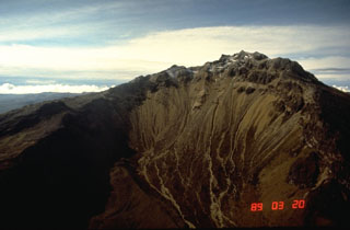
"Cumbal . . . (figure 1), has been showing signs of possible reactivation during the past year. New fumaroles have appeared and the gas column has grown noticeably larger. Cumbal was visited by volcanologists from INGEOMINAS and the Univ de Montréal on 11-15 July 1994. A portable seismometer was installed . . . at 4,185 m elev, ~580 m below the summit. Both high-frequency and long-period events were recorded, as well as some possible tremor episodes. Several fumarole fields at the summit (figure 2) exhibited maximum temperatures as follows: El Verde, 378°C; El Tábano, 191°C; La Desfondada, 132°C; La Plazuela, 99°C; La Grieta-verde, 84°C; Vecino a la verde, 80°C. El Tábano is a new fumarole field that appeared in early 1994. For comparison, in 1988 El Verde had measured temperatures of 150-326°C. The El Verde fumaroles produced audible noise. Most of the gas column at Cumbal appeared to emanate from the El Verde fumaroles."
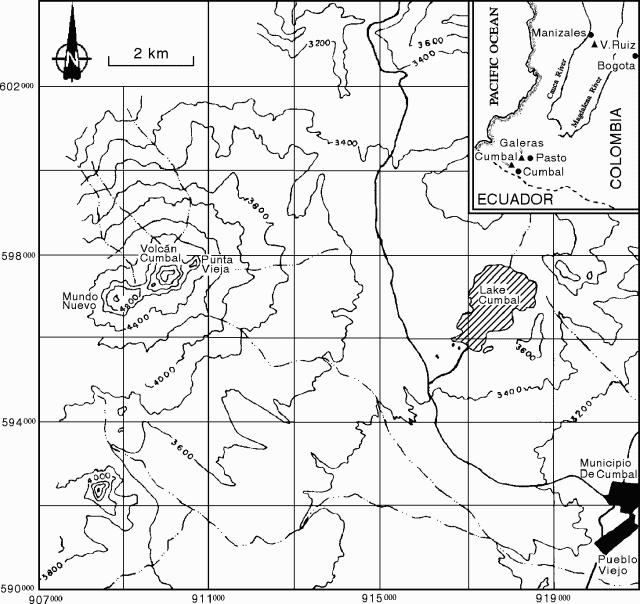 |
Figure 1. Location map showing Cumbal volcano and the city of Cumbal. Modified from Mendez (1989). |
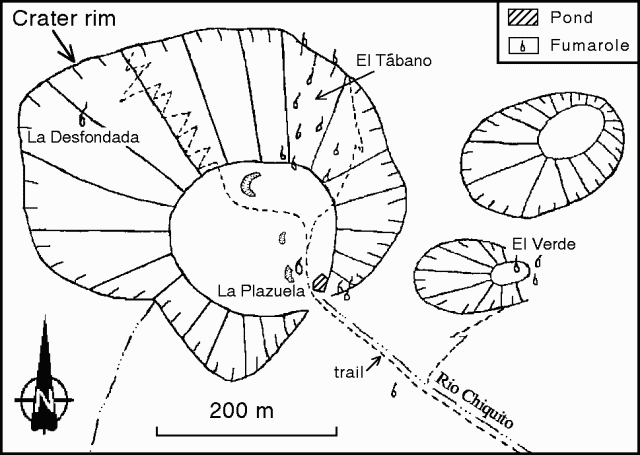 |
Figure 2. Sketch map of the crater area of Cumbal, July 1994, showing fumarole locations. Courtesy of INGEOMINAS. |
Reference. Mendez F., R.A., 1989, Catálogo de los volcanes actives de Colombia: Bol. Geol., v. 30, no. 3, 75 p.
Geological Summary. Many youthful lava flows extend from the glacier-capped Cumbal volcano, the southernmost historically active volcano of Colombia. The volcano is elongated in a NE-SW direction and is composed primarily of andesitic-dacitic lava flows. Two fumarolically active craters occupy the summit ridge: the main crater on the NE side and Mundo Nuevo crater on the SW. A young lava dome occupies the 250-m-wide summit crater, and eruptions from the upper E flank produced a 6-km-long lava field. The oldest crater lies NNE of the summit crater, suggesting SW-ward migration of activity. Explosive eruptions in 1877 and 1926 are the only known historical activity. Thermal springs are located on the SE flanks.
Information Contacts: G. Patricia Cortes and R. Torres Corredor, INGEOMINAS, Pasto; J. Stix and M. Heiligmann, Univ de Montréal.