Report on Merapi (Indonesia) — August 1994

Bulletin of the Global Volcanism Network, vol. 19, no. 8 (August 1994)
Managing Editor: Richard Wunderman.
Merapi (Indonesia) Two new broad-band seismometers detect long-period pulses and tremor
Please cite this report as:
Global Volcanism Program, 1994. Report on Merapi (Indonesia) (Wunderman, R., ed.). Bulletin of the Global Volcanism Network, 19:8. Smithsonian Institution. https://doi.org/10.5479/si.GVP.BGVN199408-263250
Merapi
Indonesia
7.54°S, 110.446°E; summit elev. 2910 m
All times are local (unless otherwise noted)
Two STS2 broad-band seismometers were deployed on 27-29 July by collaborators of the Geophysical Laboratory of GMU and Martin Beisser of GFZ-Potsdam. The researchers investigated signal coherency at different points on the volcano to find suitable sites for a multi-station seismic array that will make permanent records at a 50-Hz sampling rate. The researchers measured Merapi seismicity at a base station located at Klathakan (1.8 km WNW of the summit between 1,200-1,300 m elev), the site of a seismic station for the last eight years. The second station was mobile and GPS-equipped; however, for the following comparisons and discussion the mobile site remained 400 m N of the base station.
Figure 10 shows amplitude data for three components of volcanic shock from the mobile station. The volcanic shock event that began at 1750 and 37 seconds on 27 July is here termed Event A. Figure 11 shows the arriving signals and allows for a visual comparison of the coherency in the vertical component (top two plots), and two orthogonal horizontal components (lower four plots). From visual inspection, the best coherency appeared in the vertical-component data. Some other types of events received appeared to show less coherency between the two sites.
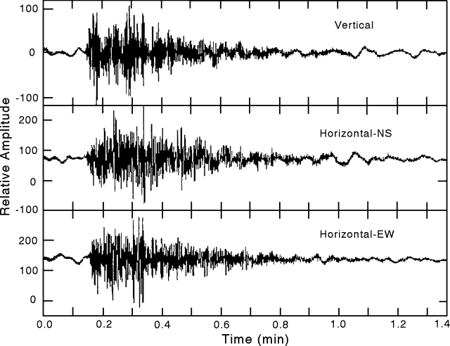 |
Figure 10. A seismic event on Merapi received at the mobile station showing 3-component amplitude data. The event shown began at 1750 and 37 seconds on 27 July 1994 and is termed "Event A." Courtesy of A. Brodscholl. |
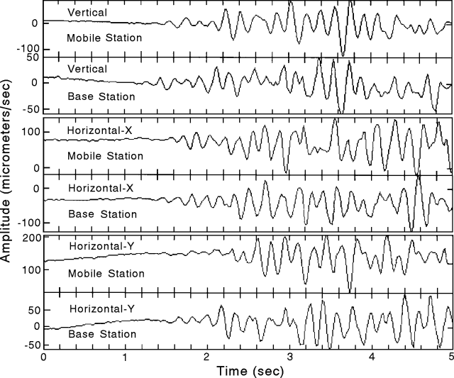 |
Figure 11. The first five seconds of Event A on Merapi (27 July 1994) as received at the broadband base and mobile stations (400-m separation). The records show considerable coherency. Courtesy of A. Brodscholl. |
Figure 12 shows three components of a previously undetected tremor type, a tremor preceded by or superimposed on a long-period pulse. On the record, the interval of greatest short-period amplitude came after the pulse's maximum. Examples of this kind of tremor were seen three times in 12 hours. Whether these events are common on Merapi and elsewhere still remains uncertain.
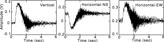 |
Figure 12. Merapi seismic record from the mobile station showing an example of tremor coming after the maximum of a long-period pulse. These pulses and temporally associated tremors were seen three times in a 12-hour period and were not previously detected. Courtesy of A. Brodscholl. |
[The reported low-frequency signal was later found to be caused by instrumental problems not recognized at the time of submission.]
Geological Summary. Merapi, one of Indonesia's most active volcanoes, lies in one of the world's most densely populated areas and dominates the landscape immediately north of the major city of Yogyakarta. It is the youngest and southernmost of a volcanic chain extending NNW to Ungaran volcano. Growth of Old Merapi during the Pleistocene ended with major edifice collapse perhaps about 2,000 years ago, leaving a large arcuate scarp cutting the eroded older Batulawang volcano. Subsequent growth of the steep-sided Young Merapi edifice, its upper part unvegetated due to frequent activity, began SW of the earlier collapse scarp. Pyroclastic flows and lahars accompanying growth and collapse of the steep-sided active summit lava dome have devastated cultivated lands on the western-to-southern flanks and caused many fatalities.
Information Contacts: M. Beisser, GFZ-Potsdam, Germany; A. Brodscholl, GMU.