Report on Unzendake (Japan) — August 1994

Bulletin of the Global Volcanism Network, vol. 19, no. 8 (August 1994)
Managing Editor: Richard Wunderman.
Unzendake (Japan) Slow endogenous growth of the lava dome; pyroclastic flows continue
Please cite this report as:
Global Volcanism Program, 1994. Report on Unzendake (Japan) (Wunderman, R., ed.). Bulletin of the Global Volcanism Network, 19:8. Smithsonian Institution. https://doi.org/10.5479/si.GVP.BGVN199408-282100
Unzendake
Japan
32.761°N, 130.299°E; summit elev. 1483 m
All times are local (unless otherwise noted)
The lava dome grew endogenously SE to SW during mid- to late-August. The S ridge on the dome top 0moved S by ~1 m/day and rose vertically by ~0.5 m/day; the central ridge decreased in height. Crest-line measurements from 3.5 km SE of the dome confirmed the endogenous growth. EDM measurements by the JMA in cooperation with the GSJ were hampered by poor weather conditions and volcanic ash. The eruption (magmatic extrusion) rate remained at a low level. The GSJ calculated the average eruption rate from early-April to mid-July as 60,000 m3/day, based on aerial photographs. This value is similar to those for February-April, although no values for the calculation error were given.
The N and S parts of the presently growing dome had no room for talus deposition (figure 75). Therefore, the advancing dome easily triggered rockfalls in both directions that moved straight downward as pyroclastic flows. Most parts of lobe 13 collapsed during 15-29 August, generating pyroclastic flows to the SW, S, and SE, which reached the Akamatsu valley. Pyroclastic flows detected seismically at a station ~1 km WSW of the dome totaled 264 during August. Real-time monitoring of pyroclastic flows is also conducted at the UWS using four sets of visible and thermal-infrared video cameras. In late August, JMA recorded the second largest daily number of pyroclastic flows since 20 May 1991, based on signals registered at the seismic station SW of the dome. This large number of events reflected smaller distances between pyroclastic flow routes and the seismic station than was previously the case.
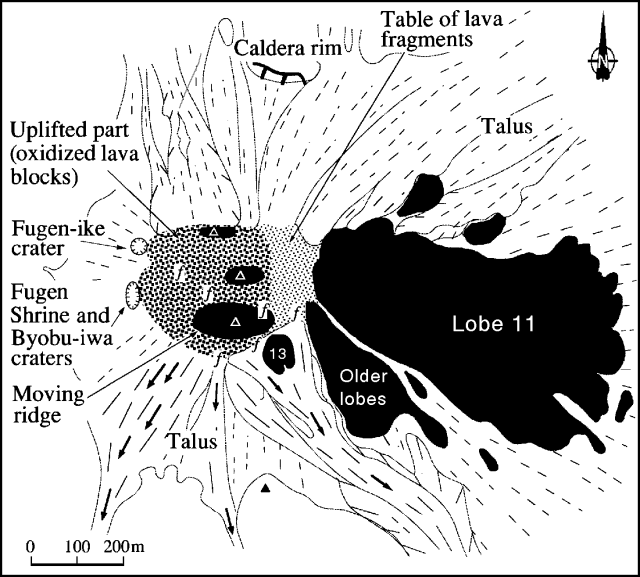 |
Figure 75. Sketch map of the lava dome at Unzen, late August 1994. Solid dome rock is shown as black. Arrows indicate the main direction of pyroclastic flows and rockfalls. Solid and dashed lines represent slope dip directions of new and old talus deposits, respectively. Volcanic gas emission points are shown by "f" symbols. Courtesy of S. Nakada, Kyushu Univ. |
On the nights of 15 and 16 August, pyroclastic flows descended SE ~400 m through a deep gully, which developed during rainy seasons at the S margin of the Akamatsu valley floor. Field inspection on 24 August showed that the 15-16 products were block-and-ash-flow deposits consisting of multiple layers each ~2 m thick. The deposits included still-hot lava blocks up to 3 m across in an ash matrix, and were covered with an ashfall layer ~10 cm thick. No associated surge deposits were evident. Gently sloped depressions ~2 m across, indicating underlying fumarolic pipes, were found on the surface of the 15-16 August deposits. The depression surfaces were reddish to yellowish brown, and lava pebbles (3. Density has increased roughly with time during this eruption (1.8 to 2.5 g/cm3); there has been a roughly negative correlation between density of lava blocks and eruption rate. The SiO2 contents of new samples were 64.7-65.1 wt.%, remaining roughly constant with previous lavas (63.5-65.5%). These results indicate that the vesicularity (porosity) of lava blocks probably decreased with time.
Pyroclastic flows moving SW passed through a gully in the S slope of the dome, crossed the Akamatsu valley floor, and came against the N wall of Mt. Iwatoko, generating frequent ash clouds. A pyroclastic flow late on 27 August traveled 2.0 km SE and produced a signal that lasted for almost 30 minutes, the longest duration since pyroclastic flows began in May 1991. Many pyroclastic flows in the last 10 days of the month had long durations, but all were considered to be triggered by small-scale collapses. On 29 August, pyroclastic flows again moved SE through the gully in the Akamatsu valley; the horizontal travel distance was ~3 km from the source. The volume of the largest pyroclastic-flow deposits during this period was estimated to be ~100,000 m3.
Microearthquakes beneath the lava dome were registered at a rate of ~50/day during the first half of August, and gradually increased in number later in the month. On 28 August, 474 earthquakes were detected at a seismic station 3.6 km SW of the dome. In total, 7,306 earthquakes were registered during August.
Geological Summary. The massive Unzendake volcanic complex comprises much of the Shimabara Peninsula east of the city of Nagasaki. An E-W graben, 30-40 km long, extends across the peninsula. Three large stratovolcanoes with complex structures, Kinugasa on the north, Fugen-dake at the east-center, and Kusenbu on the south, form topographic highs on the broad peninsula. Fugendake and Mayuyama volcanoes in the east-central portion of the andesitic-to-dacitic volcanic complex have been active during the Holocene. The Mayuyama lava dome complex, located along the eastern coast west of Shimabara City, formed about 4000 years ago and was the source of a devastating 1792 CE debris avalanche and tsunami. Historical eruptive activity has been restricted to the summit and flanks of Fugendake. The latest activity during 1990-95 formed a lava dome at the summit, accompanied by pyroclastic flows that caused fatalities and damaged populated areas near Shimabara City.
Information Contacts: S. Nakada, Kyushu Univ; JMA.