Report on Rabaul (Papua New Guinea) — September 1994

Bulletin of the Global Volcanism Network, vol. 19, no. 9 (September 1994)
Managing Editor: Edward Venzke.
Rabaul (Papua New Guinea) Tavurvur remains active; details of September eruptions
Please cite this report as:
Global Volcanism Program, 1994. Report on Rabaul (Papua New Guinea) (Venzke, E., ed.). Bulletin of the Global Volcanism Network, 19:9. Smithsonian Institution. https://doi.org/10.5479/si.GVP.BGVN199409-252140
Rabaul
Papua New Guinea
4.2459°S, 152.1937°E; summit elev. 688 m
All times are local (unless otherwise noted)
New eruptions began on 19 September 1994, ending a repose period of ~51 years. Following the pattern of the last two eruptive episodes (1878 and 1937-43), there were almost simultaneous outbursts on opposite sides of the caldera as the intracaldera cones Tavurvur and Vulcan began erupting at 0605 and 0717, respectively. The eruption at Vulcan was the more powerful and included a brief phase of strong Plinian activity soon after its onset. Vulcan's eruption ended on 2 October. The eruption at Tavurvur, after peaking during the first five days of activity, exhibited a slow decline. However, moderate to weak activity continued as of 28 October. By mid-late October, eight new 3-component seismic stations and two tilt stations had been installed by volcanologists at RVO with the assistance of USGS scientists. Many stations had been damaged or destroyed by tsunami, vandalism, or heavy ashfall during the eruption. The following report is from RVO.
Precursory activity. "A levelling survey along the usual route from the Rabaul Town area to Matupit Island was completed on 15 September. Compared with the previous survey on 19 July (19:07), the greatest change was uplift of ~25 mm at the S extremity of the island. This rate of uplift is similar to the long-term rate observed during 1973-83, prior to the 'Rabaul Seismo-Deformational Crisis Period' of 1983-85.
"For most of the time in the preceeding few months, seismicity gave little or no warning of the coming eruptions. The normal (high-frequency) seismicity on the caldera ring-fault was at a low level. Some low-frequency events were recorded, but their origin and significance are not yet known.
"The eruptions were immediately preceded by 27 hours of vigorous and fluctuating seismicity, which was initiated by two caldera earthquakes (max ML 5.1) at 0251 on 18 September. These earthquakes were located in the E part of the caldera seismic zone, near Tavurvur, at a depth of 1.2 km. The earthquakes were felt very strongly throughout the town and a small localized tsunami was generated. Seismicity over the following four hours took place near Vulcan and showed a general decline. Through this period, the pattern of seismicity appeared to be similar to many previous swarms of earthquakes on the caldera fault system. During the next ten hours (0600-1600), earthquakes continued at a steady rate, still concentrated near Vulcan. From about 1600 on 18 September, seismicity increased and reached a peak at about 0200 on 19 September; at this time, earthquakes were felt every few minutes. Seismicity then showed a slow decrease. Earthquake epicentres were concentrated in the Vulcan area until about 0430, when the focus shifted to Tavurvur.
"Soon after dawn on 19 September (0600), it was clear that an eruption was imminent because offshore areas had emerged. The most obvious uplift was at Vulcan, where a tide gauge was almost out of the water, indicating an estimated uplift of 6 m. The W and S coasts of Matupit Island had also been raised and the S shoreline was shifted ~70 m S.
Evacuation. "In consideration of the increased seismicity after about 1600 on 18 September, RVO recommended the declaration of a Stage 2 alert (eruption expected within weeks to months) around 1800. This was subsequently issued at 1815. Throughout the late afternoon a voluntary evacuation of the town had developed, but the release of the Stage 2 alert accelerated the process. At midnight, RVO advised the Provincial Disaster Committee that an eruption was imminent. By this time, people had congregated in Queen Elizabeth Park in the centre of Rabaul Town. Transport was mobilised, and during the next few hours people were ferried from the town area to beyond the caldera rim. RVO recommended a Stage 3 alert (eruption expected within days to weeks) in the early hours of the 19th, but the Disaster Committee refrained from a declaration because the evacuation appeared to be proceeding well. It was feared that announcement of a higher stage of alert might be counter-productive. The evacuation went smoothly and by around 0700 on the 19th, the town and high-risk areas were virtually deserted.
Outbreak of eruptions. "An aerial inspection had been arranged for early morning on the 19th. While waiting on the Rabaul airstrip, a small white emission cloud was noticed above the W rim of Tavurvur's summit crater at about 0603. Three minutes later, ash was seen in the emissions which appeared to originate from the SW part of Tavurvur's 1937 crater. The intensity of the emissions was low as billowing, grey, cauliflower-shaped ash clouds rose slowly and with little sound (figure 18). The ash clouds rose only a few hundred metres and were driven towards Rabaul Town by moderate SE winds. At about 0618, the ash plume had reached the S limits of the town. The strength of the eruption remained low over the next hour as darkness descended on Rabaul.
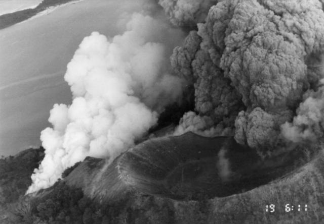 |
Figure 18. Photograph of Tavurvur taken from a helicopter at 0611 on 19 September 1994, just after the onset of activity. Note the 1878 cone (right foreground) being eaten away. View is approximately towards the ENE. Courtesy of Rod Stewart, RVO. |
"The eruption of Vulcan commenced at 0717 on 19 September with relatively small explosions on the N flank of the Vulcan 1937 cone. However, activity intensified rapidly, and by 0737 low-density pyroclastic flows were being generated and the eruption column was rising rapidly. Run-out distances of ~2 km were common for these early pyroclastic flows. At 0743, ballistic ejecta were seen landing in the water up to 1 km from the E shore of Vulcan. At about 0745 a phase of very strong activity commenced. Continuous explosions generated a Plinian eruption column that attained a height of ~20 km. The sounds of this activity were of dull thudding, quite a contrast to the sharp, loud reports of electrical discharges around the eruption column. By 0830, Rabaul Town and surrounding areas were enveloped in darkness by the spreading ash canopy. The phase of Plinian activity had ended by about 0830, but strong ash emission continued.
"A number of tsunami were generated, probably by the Vulcan activity. The largest of these rose ~5 m above high water. The SW and W parts of Matupit Island were hit numerous times by tsunami, washing inland as far as several hundred metres. Small boats were carried inland ~60 m at the head of Rabaul Harbour.
Continuing eruptions. "The activity at Tavurvur increased through the 19th and the eruption column was estimated to have reached a maximum height of ~6 km. Only one vent was active. The eruption column was very dense and the moderate SE winds drove the ash plume directly over Rabaul. No pyroclastic flows were generated at Tavurvur. Over the next few days activity at Tavurvur waned slightly. The eruption column was usually ~1-2 km high. The dense dark grey-brown ash clouds fed a plume that continued to blanket Rabaul Town with fine ash.
"At Vulcan, at least four vents were active. The main vent was at the point of the eruption outbreak. Another vent slightly to the N was active briefly. A vent in the crater of the 1937 Vulcan cone and one on its SW flank also were active. Two more phases of Plinian activity took place at Vulcan in the evening of 19 September between about 1830 and 1930. The intensity of this activity was considerably weaker than the first Plinian phase. Pyroclastic flows were formed throughout the first few days of the eruption. The largest of these extended ~3 km. Pumice from Vulcan formed a large raft that covered most of Simpson Harbour.
Sequence of felt earthquakes and decline of eruption. "On 23 September, between about 1850 and 1900, there was a sequence of strongly felt caldera earthquakes. The largest of these had an estimated magnitude of 3.5. Most of the seismic stations had been lost during the first day of the eruption, so it was not possible to locate any of these earthquakes. However, most of them appeared to originate from the SE part of the caldera. These earthquakes may have been due to structural re-adjustment of the caldera to the eruptive removal of significant quantities of magma. On the morning of 24 September, a marked decline was evident in the activity at Vulcan, and a lesser decline was seen at Tavurvur. This may have been connected with the sequence of earthquakes the previous evening. The eruption at Vulcan ended on 2 October, but Tavurvur continued erupting, generating an eruption column 1-2 km high and a plume ~20 km long.
Lava flow at Tavurvur. "A small lava flow was first noticed in the summit crater of Tavurvur on 30 September. The aa lava was emerging from a sub-terminal vent on the W flank of the growing ejecta cone. The flow rate was extremely low as the lava slowly advanced towards the W rim of the summit crater. On 5 October, a new lava lobe was seen overriding the first lobe in the summit crater of Tavurvur. This lava lobe also advanced very slowly and eventually reached the nose of the first lobe. The length of these lobes was ~100 m. Lava continued to be fed into these lobes after they had stopped advancing, causing them to thicken. Eventually, on 8 October, a breakout occurred on the W side of the original lobe. A more fluid black lava emerged, ponding between the earlier lava flows and the W crater rim. On 12 October, following a considerable growth of the body of lava within the crater, lava began spilling over the crater rim and descending Tavurvur's W flank. A second lava breakout from the earlier bulky flows within the crater took place on 14 October. This became the main feeder for the slowly advancing lava flow on the W flank of the cone. It remained active until about 25 October.
Tephra from Vulcan and Tavurvur. "The tephra from Vulcan was pale grey-brown pumice and ash, probably of dacitic composition. In contrast, Tavurvur's tephra was dominated by very fine-grained ash. Accretionary lapilli were abundant throughout both sequences and a number of ash units were extremely hard, apparently having self-cemented on deposition. The base of the Tavurvur sequence was marked by a blue-grey very fine ash that appeared to be rich in sulphides. This material probably originated as a hydrothermal clay on the crater floor. Late in the Tavurvur sequence was a pumiceous unit that may be sub-Plinian. During 8-18 October, strong explosions ejected ballistic material as far as 1.5 km from Tavurvur's summit. Large blocks (to ~1 m size) were found partially buried in the road around the N and E foot of Tavurvur. These ejecta included a mixture of dense glassy lava blocks, porphyritic lava blocks, and pumiceous bombs.
Sulfur dioxide emissions. "SO2 emission rates from Tavurvur were measured in the period from 29 September to 6 October by Stan Williams (Arizona State Univ). Preliminary results indicated a progressive decline from ~30,000 to ~3,000 t/d.
Ground deformation. "Tilt measurements, which started at Matupit Island on 24 September, indicated a large deflation (~930 µrad) of the central part of the caldera compared with pre-eruption values, and a slowly reducing rate of deflation during the eruption. The rate of deflation declined from ~10 to ~2 µrad/day between 24 September and 25 October. Sea-shore levelling measurements, which started in late September, indicated minor subsidence over most of the caldera compared with pre-eruption levels. The greatest subsidence was ~80 cm in the area of Rabaul Airport, between Matupit Island and the town. About 3 m of uplift was recorded at the E shore of Vulcan and slight uplift was recorded at the S end of Matupit Island. Geodetic levelling from outside the caldera, through Rabaul Town, and onto Matupit Island, confirmed these results.
Effects of the eruption. "The official death toll from the eruptions and associated events was five; four of which were due to house roofs collapsing. One person was killed by lightning. Over 50,000 people have been displaced by the eruptions and were in care centres in safe areas of the Gazelle Peninsula as of the end of October.
"The rapid accumulation of ash on Rabaul Town caused collapse of some buildings within a few hours of the onset of the eruptions. Ashfall from Tavurvur in the first few days of the eruption caused widespread damage in Rabaul Town; virtually every building in the S part of town collapsed. Serious structural damage was sustained by most buildings in the ashfall zone within 8 km of Tavurvur. All housing in the immediate area of Vulcan (to ~2 km) was destroyed within ~1 hour of the start of the Vulcan eruption by a combination of pyroclastic flows and heavy ashfall.
"Heavy rainfall during the first day and night of the eruption exacerbated the effects of heavy ashfall. Mudflows and floods were widespread in the Rabaul Town area, near Vulcan, and immediately outside the Rabaul Caldera to the NW. The most serious floods were NW of the caldera, where the heavy ashfall caused rapid runoff and eventual deep erosion and migration of stream channels. The obliteration of rainforest cover around Rabaul will present a serious risk of flash floods and mudflows at times of heavy rainfall. The wet season in Rabaul normally starts in early December.
Satellite imagery. "The westwards-spreading ash plume . . . was clearly visible from Earth-imaging satellites. A wide-angle plume (90°) was seen on a series of Japanese GMS images as a triangular area at 0903 of 19 September, spreading at different wind levels in a fan extending from Rabaul. The N edge of the plume trended NW, and the S edge to the SW, extending across the E Bismarck Sea and moving down the N coast of New Britain.
"A similar spreading pattern was seen on images (IR channel 4) from the NOAA-12 polar orbiting satellite (19:08). The SE margin of the cloud at 1800 on 19 September was seen curving S over the Solomon Sea and SE New Guinea, with the NE margin extending past Manus Island. All parts of Papua New Guinea to the W of these margins were covered by the eruption cloud. The strongly sheared cloud seen on subsequent images was being driven S and then E by high-level winds towards the Fiji region.
"AVHRR imagery from the Nimbus-7 satellite showed similar ash-cloud dispersal patterns. However, computation of the temperature differences recorded between AVHRR IR channels 4 and 5 at 1905 on 19 September and 0747 the next day yielded unexplained patterns in which negative temperature differences (T4-T5), thought to be indicative of ash-bearing clouds, were restricted to 1° of latitude W of Rabaul (F. Prata, pers. comm. to RVO). In addition, the SO2 signature seen on TOMS images at 1520 on the 20th and 1503 on the 21st (19:08) were restricted to the E corner of the Bismarck Sea W of Rabaul, or over the general Rabaul area. Both of these aspects of the satellite imagery require further consideration and study."
Jim Lynch (NOAA Synoptic Analysis Branch) provided the following satellite interpretation. NOAA and GMS satellite imagery clearly depicted the volcanic plume during the first three days of the eruption (19-22 September). The size and shape of the plume during the first 18 hours is shown on figure 19. By correlating plume drift with available wind data, the maximum height of the original plume was estimated at 21-30 km altitude, well into the stratosphere. The eruption maintained the plume to this altitude for ~12 hours before tapering off to 12-18 km. After the first 56 hours of continuous activity there was apparently a 6-hour respite, after which the eruption resumed at a moderate intensity, generating a plume to 21 km) blew W and WNW toward Borneo and Southeast Asia; however, the plume became too diffuse to track beyond 1,300 km from the volcano. The upper tropospheric plume (12-18 km) tracked SW, then S, and finally SE for ~1,000 km around an upper-level ridge before it became too diffuse to track with standard infrared imagery. The denser, more opaque portion of the plume remained within ~400 km of the volcano. Analyses of visible, infrared, and multispectral imagery from NOAA-12 and GMS satellites definitively depicted an ash plume only within 1,000 km of the volcano. Analysis of TOMS data revealed a relatively small amount of SO2 (80 kt) close to the volcano (19:08). The fact that a dense plume of ash and aerosols did not remain in the upper atmosphere suggests that the ash plume was composed mostly of large particulates that fell out of the atmosphere near and just downwind from the volcano.
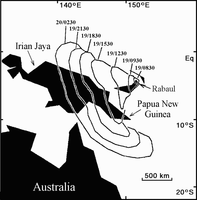 |
Figure 19. Areal extent and propagation of ash from Rabaul by upper-level winds from 0830 on 19 September to 0230 on 20 September 1994. Isochrones are based on analysis of GMS infrared imagery. Courtesy of Jim Lynch, NOAA. |
Geological Summary. The low-lying Rabaul caldera on the tip of the Gazelle Peninsula at the NE end of New Britain forms a broad sheltered harbor utilized by what was the island's largest city prior to a major eruption in 1994. The outer flanks of the asymmetrical shield volcano are formed by thick pyroclastic-flow deposits. The 8 x 14 km caldera is widely breached on the east, where its floor is flooded by Blanche Bay and was formed about 1,400 years ago. An earlier caldera-forming eruption about 7,100 years ago is thought to have originated from Tavui caldera, offshore to the north. Three small stratovolcanoes lie outside the N and NE caldera rims. Post-caldera eruptions built basaltic-to-dacitic pyroclastic cones on the caldera floor near the NE and W caldera walls. Several of these, including Vulcan cone, which was formed during a large eruption in 1878, have produced major explosive activity during historical time. A powerful explosive eruption in 1994 occurred simultaneously from Vulcan and Tavurvur volcanoes and forced the temporary abandonment of Rabaul city.
Information Contacts: C. McKee, with contributions fromRVO Staff and R. Johnson, RVO; J. Lynch, SAB; D. Dzurisin and C. Miller, CVO.