Report on Unzendake (Japan) — September 1994

Bulletin of the Global Volcanism Network, vol. 19, no. 9 (September 1994)
Managing Editor: Edward Venzke.
Unzendake (Japan) Endogenous dome growth slows; erosion of talus slopes
Please cite this report as:
Global Volcanism Program, 1994. Report on Unzendake (Japan) (Venzke, E., ed.). Bulletin of the Global Volcanism Network, 19:9. Smithsonian Institution. https://doi.org/10.5479/si.GVP.BGVN199409-282100
Unzendake
Japan
32.761°N, 130.299°E; summit elev. 1483 m
All times are local (unless otherwise noted)
Almost no advancement of the talus slopes took place from September to October. However, small pyroclastic flows and rockfalls occurred to the S during September and to the N during October (figure 76). These collapses resulted in the formation of small horseshoe-shaped craters on the talus slopes. The top of the dome decreased in elevation from 1,490 m in July, to 1,470 m in August, and to 1,460 m by October. The top of the endogenous dome, which was cone-shaped, exhibited a flat morphology by August with gentle depressions in some parts, including the E-W-trending ridges. These morphological changes were accompanied by a decrease in eruption rate to3/day.
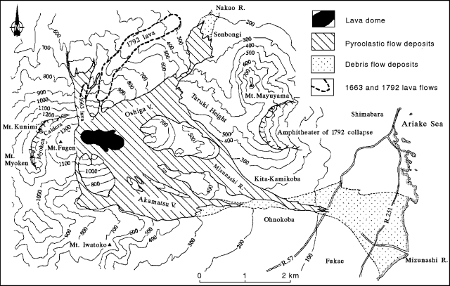 |
Figure 76. Map showing distribution of pyroclastic-flow and debris-flow deposits at Unzen from 1991 through early October 1994. Directions of recent pyroclastic flows were limited to either N or S of the dome. The 1663 andesitic lava flow has been eroded and completely covered by new pyroclastic-flow deposits. Courtesy of Setsuya Nakada. |
Pyroclastic flows caused by lava dome collapse, detected seismically ~1 km WSW of the dome, totaled 128 in September. Most of the pyroclastic flows occurred during 11-13 September, and none took place late in the month. The pyroclastic flows moved SW and SE, reaching the Akamatsu Valley; the longest of the month traveled 2.5 km SE.
On 1 September, 439 microearthquakes beneath the lava dome were registered at a seismic station ~3.6 km SW, but they gradually decreased in number throughout the month to 20/day. The total number of earthquakes for September was 3,260. Crest-line theodolite measurements from the UWS revealed that endogenous growth almost stopped in mid-September. EDM on the N flank by the JMA and GSJ indicated shortening of 10 mm/day during the second half of September.
Geological Summary. The massive Unzendake volcanic complex comprises much of the Shimabara Peninsula east of the city of Nagasaki. An E-W graben, 30-40 km long, extends across the peninsula. Three large stratovolcanoes with complex structures, Kinugasa on the north, Fugen-dake at the east-center, and Kusenbu on the south, form topographic highs on the broad peninsula. Fugendake and Mayuyama volcanoes in the east-central portion of the andesitic-to-dacitic volcanic complex have been active during the Holocene. The Mayuyama lava dome complex, located along the eastern coast west of Shimabara City, formed about 4000 years ago and was the source of a devastating 1792 CE debris avalanche and tsunami. Historical eruptive activity has been restricted to the summit and flanks of Fugendake. The latest activity during 1990-95 formed a lava dome at the summit, accompanied by pyroclastic flows that caused fatalities and damaged populated areas near Shimabara City.
Information Contacts: S. Nakada, Kyushu Univ; JMA.