Report on Klyuchevskoy (Russia) — September 1994
Bulletin of the Global Volcanism Network, vol. 19, no. 9 (September 1994)
Managing Editor: Edward Venzke.
Klyuchevskoy (Russia) Eruption sends plume to 15-20 km altitude and produces lava flows
Please cite this report as:
Global Volcanism Program, 1994. Report on Klyuchevskoy (Russia) (Venzke, E., ed.). Bulletin of the Global Volcanism Network, 19:9. Smithsonian Institution. https://doi.org/10.5479/si.GVP.BGVN199409-300260
Klyuchevskoy
Russia
56.056°N, 160.642°E; summit elev. 4754 m
All times are local (unless otherwise noted)
During 15-19 September, gas-and-ash bursts rose 500-700 m above the crater. The eruption column reached 1.5-2.0 km above the crater and extended >50 km downwind to the SE. Lava flows extruding from two vents 200 m below the crater rim had moved down to 2,800 m elevation on the NW and SW flanks. Phreatic explosions were occurring at the contact of the NW lava flow and the glacier. Lava fountains in the central crater reached heights of 300-500 m. Continuous volcanic tremor, with a maximum amplitude of 6.1 µm, was recorded at the seismic station 11 km from the volcano.
From 20 to 23 September, gas-and-ash bursts increased in height to 800-1,000 m above the crater. The eruption column continued to reach ~2 km above the crater, but extended >100 km SE. Lava flows on the NW and SW flanks remained active, and fountains in the central crater increased to heights of 500-700 m. Volcanic tremor was continuous with a maximum amplitude of 8.2 µm.
Eruptive activity increased on the afternoon of 30 September. Ash bursts rose 3 km above the crater and the ash column reached an estimated altitude of 10 km and extended SE for >100 km. Lava flows on the NW and SW slopes of the volcano remained active, and mudflows were noted on the N slope. Continuous volcanic tremor had a maximum amplitude of 8.4 µm.
At 0600 on 1 October the eruption entered a paroxysmal stage with lava bursts rising 4,500 m above the crater rim. The ash column was estimated at 15-20 km altitude and extended >100 km SE. Phreatic explosions along the margin of the flank lava flows generated steam clouds >1 km high. Avalanches of incandescent blocks were observed descending the N slope. Between 0900 and 1100, ash and lava bursts produced a dark, ash-laden plume rising to a height of 15-18 km and moving ESE. GMS satellite imagery showed ash ~565 km SE moving at ~140 km/hour. By 1400 the dark ash plume reached 15 km altitude. Lava and ash explosions continued from the central crater at 1500, when the ash column rose to 12-14 km above sea level and moved ESE at an altitude of 10-11 km. Pilot reports indicated that the ash was at 9-11 km (FL300-370 = 30,000-37,000 feet). A 747 aircraft reported an ash encounter at 11 km altitude, but avoided the cloud by climbing to ~12 km (FL390). Helicopter observations at 1500-1700 revealed two lava flows on the N and NW slopes and lava fountaining to 900 m above the crater rim. The eruption appeared to reach its maximum intensity between 0600 and 1630. By 1900 the ash plume was at a maximum altitude of 9-11 km and drifting E for >100 km. Volcanic tremor was continuous with a maximum amplitude of 8.4 µm. Analysis of GMS infrared imagery at 2330 showed a thin concentrated plume extending generally SE, surrounded by areas of thinner ash.
After about 0530 on 2 October, layered weather clouds moving from the W had obscured the summit from GMS satellite observation, although the dissipating ash cloud could be seen SE of the volcano. At 0920 a dark ash plume rose to ~8.4-8.7 km altitude and drifted E, but by 1100 the plume was only rising to 6-7 km and drifting NNE. Areas of thick, moderate, and thin dispersing ash, E and S of the volcano beyond the obscuring weather clouds, continued to be tracked by satellite through 2030. By that time, the ash cloud was becoming more diffuse and harder to distinguish from underlying low-level clouds.
The volcano was obscured by clouds on 3 October. Volcanic tremor with a maximum amplitude of 1-2.5 Nm indicated that the eruption was continuing, but at a reduced rate. On 4 October, only fumarolic activity appeared to be occurring inside the summit crater and no incandescence could be seen at night. The gas-and-steam plume rose ~1 km above the crater and was directed S for ~5 km.
Meteor-3 TOMS overflew the eruption plume at 1347 on 1 October. Preliminary results showed an extended SO2 cloud ~800 km long to the SE, with an approximate area of 150,000 km2. Estimated cloud mass was 90 kt SO2 +- 50%. A pass at 1520 on 2 October did not find an SO2 cloud.
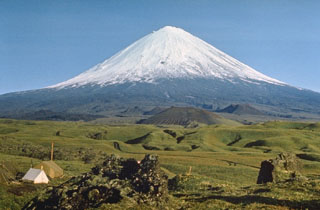
Geological Summary. Klyuchevskoy is the highest and most active volcano on the Kamchatka Peninsula. Since its origin about 6,000 years ago, this symmetrical, basaltic stratovolcano has produced frequent moderate-volume explosive and effusive eruptions without major periods of inactivity. It rises above a saddle NE of Kamen volcano and lies SE of the broad Ushkovsky massif. More than 100 flank eruptions have occurred during approximately the past 3,000 years, with most lateral craters and cones occurring along radial fissures between the unconfined NE-to-SE flanks of the conical volcano between 500 and 3,600 m elevation. Eruptions recorded since the late 17th century have resulted in frequent changes to the morphology of the 700-m-wide summit crater. These eruptions over the past 400 years have originated primarily from the summit crater, but have also included numerous major explosive and effusive eruptions from flank craters.
Information Contacts: V. Kirianov, IVGG; J. Lynch, SAB; I. Sprod, GSFC.