Report on Cerro Negro (Nicaragua) — September 1994
Bulletin of the Global Volcanism Network, vol. 19, no. 9 (September 1994)
Managing Editor: Edward Venzke.
Cerro Negro (Nicaragua) Tremor increases after 7 September, but no steam or ash
Please cite this report as:
Global Volcanism Program, 1994. Report on Cerro Negro (Nicaragua) (Venzke, E., ed.). Bulletin of the Global Volcanism Network, 19:9. Smithsonian Institution. https://doi.org/10.5479/si.GVP.BGVN199409-344070
Cerro Negro
Nicaragua
12.506°N, 86.702°W; summit elev. 728 m
All times are local (unless otherwise noted)
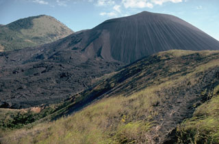
After the last eruption of Cerro Negro in April 1992 (BGVN 17:03 and 17:04), telemetry-equipped seismic instruments donated by the Japanese government were installed in November 1993. During the previous 10 months, seismic behavior has chiefly consisted of low-amplitude high-frequency events, but beginning on 7 September this changed. Tremor amplitudes increased, first to 2 mm but later reaching 10-12 mm, and tremor episodes lasted from minutes to hours. Field observers inspecting the summit on 15 September found neither steam nor fresh ash. Tremor and high-frequency seismicity continued through 30 September. Other recent fieldwork has investigated the extent of passive degassing and the chemical composition of the emissions (BGVN 19:06).
Geological Summary. Nicaragua's youngest volcano, Cerro Negro, was created following an eruption that began in April 1850 about 2 km NW of the summit of Las Pilas volcano. It is the largest, southernmost, and most recent of a group of four youthful cinder cones constructed along a NNW-SSE-trending line in the central Marrabios Range. Strombolian-to-subplinian eruptions at intervals of a few years to several decades have constructed a roughly 250-m-high basaltic cone and an associated lava field constrained by topography to extend primarily NE and SW. Cone and crater morphology have varied significantly during its short eruptive history. Although it lies in a relatively unpopulated area, occasional heavy ashfalls have damaged crops and buildings.
Information Contacts: H. Taleno, L. Urbina, C. Lugo, and O. Canales, INETER.