Report on Aira (Japan) — November 1994

Bulletin of the Global Volcanism Network, vol. 19, no. 11 (November 1994)
Managing Editor: Richard Wunderman.
Aira (Japan) Explosive activity continues; summary of aviation hazards and mitigation efforts
Please cite this report as:
Global Volcanism Program, 1994. Report on Aira (Japan) (Wunderman, R., ed.). Bulletin of the Global Volcanism Network, 19:11. Smithsonian Institution. https://doi.org/10.5479/si.GVP.BGVN199411-282080
Aira
Japan
31.5772°N, 130.6589°E; summit elev. 1117 m
All times are local (unless otherwise noted)
Explosive volcanism continued through November 1994; it caused no damage and was lower than last month in both the number of eruptions and the mass of ash fall collected. There were 21 eruptions from Minami-dake crater, including eight explosive ones. The highest ash plume in November rose to 2,700 m (at 1435 on 10 November). Seismic swarms were registered at a seismic station 2.3 km NW of Minamidake cone between 1900 on 30 November and 0700 on 1 December; earthquakes for the month numbered 427. During November, the mass of ash fall collected [at KLMO], was 60 g/m2.
Volcano monitoring at Kagoshima airport. Recent papers discussed the challenge of operating aircraft in vicinity of active volcanoes, including Sakura-jima (Onodera and Kamo, 1994; Casadevall, 1994). In Japan, 19 out of 83 volcanoes are actively steaming and under constant surveillance by JMA headquarters or local observatories; the other volcanoes are regularly patrolled by "Mobile Volcanic Observation Teams" based in four cities. These surveillance groups disseminate critical eruption information to relevant organizations, for example, Aviation Weather Service Centers, Air Traffic Control Centers, and airlines.
The key components of the Sakura-jima monitoring system consist of a seismometer for detecting earthquakes and an infrasonic microphone for detecting air shocks produced by explosive eruptions. An additional prediction system includes other instruments, such as water tube tiltmeters and extensometers. Even though the monitoring system can detect volcanic emissions nearly instantaneously, a time delay of at least a couple of minutes allows volcanological officers to confirm the responses of the monitoring equipment. This time delay also allows for time to edit and dispatch outgoing SIGMET or notification messages. In general, a SIGMET (Significant Meteorological Event) gets issued when the volcanic ash cloud reaches cruising flight elevation or higher.
While in general the several-minute time delay may not cause serious aviation safety problems, it may be crucial when aircraft are close to volcanoes, as at Sakura-jima. In considering problems such as these, the investigators developed a working model to quantify hazards. They expressed the relationship between magnitude of danger (D), eruption magnitude (M), volcano-aircraft distance (L), and a constant that may be affected by wind and related atmospheric conditions (k): D = kM/L.
Aircraft operations adjacent Sakura-jima. Figure 18 shows Kagoshima airport, at the S tip of Kyushu Island, sitting 22 km N of Sakura-jima's active crater. One of Japan's busiest airports, it has about 130 large transport takeoffs and landings a day; aircraft on the lowest category approach (ILS RWY34) pass a point 17 km NE of Sakura-jima's crater. Meanwhile, Sakura-jima produces over 100 explosive eruptions a year on average, but over 400 eruptions on some years (figure 19). Ash production has also been measured for the years 1978-93 (figure 20). It varied by a factor of about 5.5. At Sakura-jima there were 12 encounters between aircraft and volcanic ash during the years 1975-91 (Onodera and Kamo, 1994).
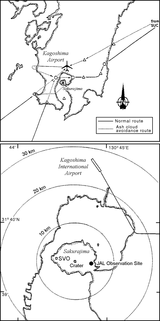 |
Figure 18. Sakura-jima airport showing both normal and ash avoidance air routes (top). More detailed map of the volcano and airport showing an air route and the JAL observation site (bottom). Courtesy of Onadera, Iguchi, and Ishihara. |
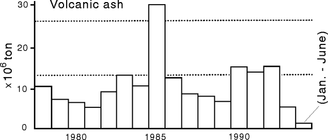 |
Figure 19. Annual number of explosions and mass of ashfall from Sakura-jima (1978-1993, with 1994 annual total up to July also shown). Courtesy of Onadera, Iguchi, and Ishihara. |
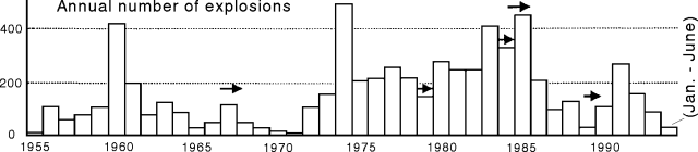 |
Figure 20. Annual number of explosions from Sakura-jima (1955 to July 1994). Arrows indicate small pyroclastic-flow episodes. Courtesy of Onadera and others (1994). |
References. Onodera, S., Iguchi, M., and Ishihara, K., Recent advances in Japan, Volcano monitoring system of Japan Airlines at Kagoshima Airport: 9th Annual International Oceanic Airspace Conference, 9 November 1994.
Casadevall, T.J., 1994, Volcanic ash and aviation safety: Proceedings of the first International Symposium on Volcanic Ash and Aviation Safety, July 1991, Seattle, Washington, USGS Bulletin 2047, 450 p.
Geological Summary. The Aira caldera in the northern half of Kagoshima Bay contains the post-caldera Sakurajima volcano, one of Japan's most active. Eruption of the voluminous Ito pyroclastic flow accompanied formation of the 17 x 23 km caldera about 22,000 years ago. The smaller Wakamiko caldera was formed during the early Holocene in the NE corner of the caldera, along with several post-caldera cones. The construction of Sakurajima began about 13,000 years ago on the southern rim and built an island that was joined to the Osumi Peninsula during the major explosive and effusive eruption of 1914. Activity at the Kitadake summit cone ended about 4,850 years ago, after which eruptions took place at Minamidake. Frequent eruptions since the 8th century have deposited ash on the city of Kagoshima, located across Kagoshima Bay only 8 km from the summit. The largest recorded eruption took place during 1471-76.
Information Contacts: JMA; S. Onodera, Japan Airlines; K. Kamo, M. Iguchi, and K. Ishihara, Sakurajima Volcano Observatory, Kyoto Univ.