Report on Irazu (Costa Rica) — November 1994

Bulletin of the Global Volcanism Network, vol. 19, no. 11 (November 1994)
Managing Editor: Richard Wunderman.
Irazu (Costa Rica) Shallow earthquake (M 3.4) and early December explosion
Please cite this report as:
Global Volcanism Program, 1994. Report on Irazu (Costa Rica) (Wunderman, R., ed.). Bulletin of the Global Volcanism Network, 19:11. Smithsonian Institution. https://doi.org/10.5479/si.GVP.BGVN199411-345060
Irazu
Costa Rica
9.979°N, 83.852°W; summit elev. 3436 m
All times are local (unless otherwise noted)
During November, Irazú produced [no explosions, but] was shaken by a seismic event. In the interval 7-18 November a seismic swarm took place during which the OVSICORI seismic station registered a total of 255 seismic events. There were 42 locatable events that fell on a 10-km-long segment of the NW- to SE-trending Irazú fault (figure 6). The earthquakes ranged in magnitude, M 2.0-3.4, and some had focal depths of 27-29 km, though others had depths of <8 km. Similar alignments of epicenters have been seen on the fault since 1991. These epicenters suggest that the fault extends across Irazú. The seismic swarm terminated at 1337 on 18 November when a M 3.4 event occurred. Its epicenter fell 3 km SSE of the active crater. During this time, deformation detected via the inclinometer network failed to show significant changes. But, in contrast, around this time a leveling line 4 km S of the active crater did show a pulse of inflation: 32 µrad.
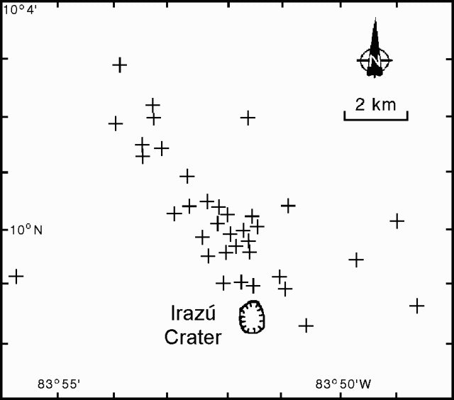 |
Figure 6. Irazú earthquake epicenters, 7-18 November 1994. Courtesy of OVSICORI-UNA. |
ICE reported that at 2248 on 8 December there was a phreatic explosion vented from a well-established fumarole on the upper NW-flank. They suggested that based on the response of the seismic station in San José, the released energy was similar to a M 4.4 earthquake. They further suggested that the explosion traveled toward the NW and destroyed forest on the upper slopes of the Rio Sucio, down to 2,500 m elevation. Explosion-triggered landslides and mudflows also followed along that drainage, but no lives were lost due to the absence of inhabitants in that area. The ash was composed of particles that appeared to be hydrothermally altered lithic fragments. The ash distribution pattern trended W (at an azimuth of 250°) and reached <= 30 km from the vent.
After the 8 December explosion, several tectonic earthquakes took place adjacent to Irazú, the largest, M 3.2 (at 0519 on 14 December) had a focal depth of 7 km. The explosion was also followed by many low-frequency and tremor-like signals. These were possibly triggered by the explosion.
Geological Summary. The massive Irazú volcano in Costa Rica, immediately E of the capital city of San José, covers an area of 500 km2 and is vegetated to within a few hundred meters of its broad summit crater complex. At least 10 satellitic cones are located on its S flank. No lava effusion is known since the eruption of the Cervantes lava flows from S-flank vents about 14,000 years ago, and all known Holocene eruptions have been explosive. The focus of eruptions at the summit crater complex has migrated to the W towards the main crater, which contains a small lake. The first well-documented eruption occurred in 1723, and frequent explosive eruptions have occurred since. Ashfall from the last major eruption during 1963-65 caused significant disruption to San José and surrounding areas. Phreatic activity reported in 1994 may have been a landslide event from the fumarolic area on the NW summit (Fallas et al., 2018).
Information Contacts: E. Fernández, J. Barquero, R. Van der Laat, F. de Obaldia, T. Marino, V. Barboza, and R. Sáenz, OVSICORI; G. Soto, Guillerma E. Alvarado, and Francisco (Chico) Arias, ICE.