Report on Irazu (Costa Rica) — December 1994

Bulletin of the Global Volcanism Network, vol. 19, no. 12 (December 1994)
Managing Editor: Richard Wunderman.
Irazu (Costa Rica) Phreatic explosion on 8 December
Please cite this report as:
Global Volcanism Program, 1994. Report on Irazu (Costa Rica) (Wunderman, R., ed.). Bulletin of the Global Volcanism Network, 19:12. Smithsonian Institution. https://doi.org/10.5479/si.GVP.BGVN199412-345060
Irazu
Costa Rica
9.979°N, 83.852°W; summit elev. 3436 m
All times are local (unless otherwise noted)
On 8 December 1994 a small phreatic explosion vented from a well-established fumarole on the upper NW-flank (figure 7). Eighteen shallow October earthquakes (M <=2) and a 255-event November seismic swarm were both discussed in previous reports (19:10-11). ICE workers have suggested that based on the response in San José (station RSN of the national network), the explosion's released energy was similar to a M 4.4 earthquake. In addition, ICE workers noted that people living near Irazú felt the event with an intensity of IV on the modified Mercalli scale. Some residents also heard a jet-like sound and more than one explosion.
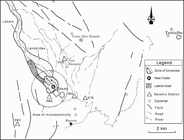 |
Figure 7. Sketch map illustrating the material associated with the phreatic explosion at Irazú, 8 December 1994. Courtesy of ICE. |
Prior to the 8 December explosion, but in the same area where it later took place, residents living nearby on the N-flank heard the sound of landslides beginning in November 1994. The sounds came from the N and NW sides of the volcano, an area underlain by deeply incised, altered rocks. The same area has hosted intense fumarolic activity, first observed in 1886. The fumaroles have remained active since then and in the last few years reached temperatures up to 95.4°C.
ICE reported that air surveys and field work completed a few days after the 8 December explosion revealed that the event left an irregularly shaped crater 60-80 m in diameter. Deposits related to landslides, lahars, and a small "lateral blast" were chiefly confined to one drainage radiating from the summit (figure 7). The blast apparently produced no juvenile material, but it deposited blocks, ash, sand, and mud. OVSICORI workers pointed out that after the explosion ash was carried SW and there were other tenuous reports of ashfall in an area 22 km W of the volcano and about 3 km from the capital.
Seismicity was erratic from the end of October through the end of December (figure 8). Although the 8 December event was followed neither by significant explosions nor earthquakes of comparable magnitude, on 9 December nearly 70 smaller earthquakes were registered on a newly installed portable system. That system, which began operation on 9 December, was placed very near the new explosion crater (station PHE, figure 7). Earthquakes declined in number after that (figures 8 and 9), and 5-7 days after the explosion even the system nearest the active crater detected only a few low-frequency events (figure 9).
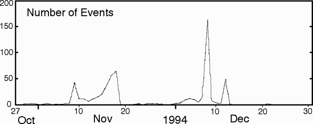 |
Figure 8. Number of earthquakes at Irazú during the interval 27 October through December 1994. Collected at seismic station IRZ2, 5 km SW of the main crater. Courtesy of OVSICORI. |
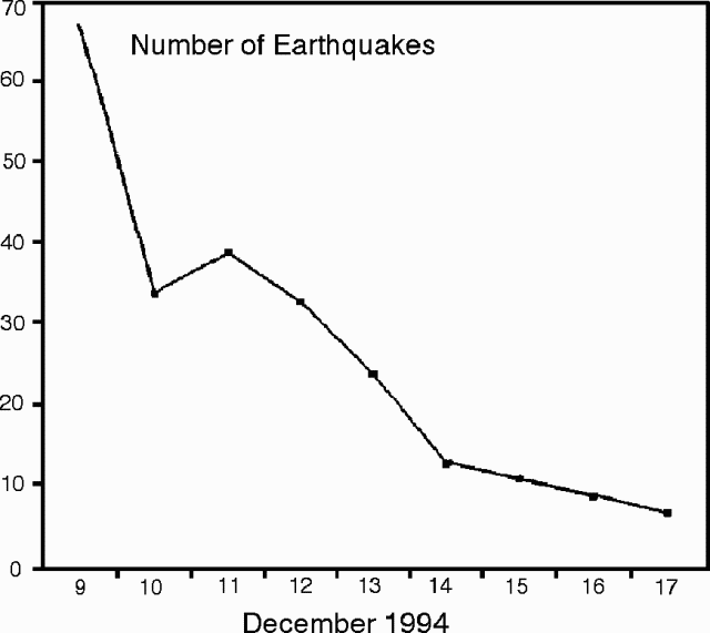 |
Figure 9. Number of earthquakes at Irazú during the interval 9 December to the middle of 17 December 1994. Collected using a portable system situated at the W end of Playa Hermosa ~800 m from the new explosion crater (station PHE, figure 1). Courtesy of ICE. |
ICE workers interpreted the explosion as small, phreatic, and they associated it with the November seismic swarm, decompression of a shallow hydrothermal system, and heavy rains destabilizing the NW flank. They also advocated increased seismic monitoring at the volcano.
Geological Summary. The massive Irazú volcano in Costa Rica, immediately E of the capital city of San José, covers an area of 500 km2 and is vegetated to within a few hundred meters of its broad summit crater complex. At least 10 satellitic cones are located on its S flank. No lava effusion is known since the eruption of the Cervantes lava flows from S-flank vents about 14,000 years ago, and all known Holocene eruptions have been explosive. The focus of eruptions at the summit crater complex has migrated to the W towards the main crater, which contains a small lake. The first well-documented eruption occurred in 1723, and frequent explosive eruptions have occurred since. Ashfall from the last major eruption during 1963-65 caused significant disruption to San José and surrounding areas. Phreatic activity reported in 1994 may have been a landslide event from the fumarolic area on the NW summit (Fallas et al., 2018).
Information Contacts: G. Soto, Guillermo E. Alvarado, and Francisco (Chico) Arias, ICE; E. Fernández, J. Barquero, R. Van der Laat, F. de Obaldia, T. Marino, V. Barboza, and R. Sáenz, OVSICORI.