Report on Ruapehu (New Zealand) — January 1995

Bulletin of the Global Volcanism Network, vol. 20, no. 1 (January 1995)
Managing Editor: Richard Wunderman.
Ruapehu (New Zealand) Small phreatic eruptions in crater lake
Please cite this report as:
Global Volcanism Program, 1995. Report on Ruapehu (New Zealand) (Wunderman, R., ed.). Bulletin of the Global Volcanism Network, 20:1. Smithsonian Institution. https://doi.org/10.5479/si.GVP.BGVN199501-241100
Ruapehu
New Zealand
39.28°S, 175.57°E; summit elev. 2797 m
All times are local (unless otherwise noted)
Some key descriptive and eruptive data on Ruapehu are summarized on figure 16 and table 5.
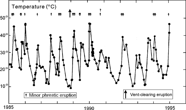 |
Figure 16. Ruapehu Crater Lake activity and surface lake temperature at Outlet, 1985 through January 1995. Courtesy of IGNS. |
Table 5. Summary of Ruapehu crater lake observations, January 1995. Courtesy of IGNS.
| Date | Observations |
| 06 May 1994-13 Jan 1995 | Deformation showed no volcanologically significant distance changes seen (line IJ unmeasurable due to snow). |
| after 25 Nov 1994 | Seismicity generally low except for moderate earthquakes mentioned in text. |
| after 30 Nov 1994 | Tremor generally <=200 Watts at a dominant frequency of about 2 Hz. |
| 07 Dec 1994 | Outflow rate 80 liters/second. |
| 13 Jan 1995 | Lake was battleship gray, steaming vigorously, with sudden, 1-2 m high upwelling. Outlet temperature 41.5°C. Outflow rate 500-600 liters/second. |
| 18 Jan 1995 | Outlet temperature 46.5°C. Outflow rate >600 liters/second. |
"Ruapehu Crater Lake has been in a heating phase since ~25 November with the Outlet temperature rising from 17°C to 46.5°C by 18 January, and the ARGOS [satellite-relayed] temperature (at 20 m depth) rising from 17°C to 47.5°C during 25 November to 12 January. The 6.5°C differential between Outlet and ARGOS temperatures on 12 and 13 January appears to be common during a heating phase. Note that the unusually high outflow of 6m3 heating at a mean rate of 0.7°C/day).
"Small phreatic eruptions have been occurring since ~11 January, or earlier. No associated seismicity or acoustic noise has been recognized, indicating typical open vent conditions."
S. Sherburn reported that there were two weeks in December without seismic data, but between 24 December and 2 January a series of moderate earthquakes took place ~12 km W of the summit (the largest, M 4.3 and 4.4). These earthquakes were not interpreted as related to the activity at Crater Lake. Otherwise seismicity has remained low.
I. Nairn reported that on 13 January Crater Lake was "steaming vigorously both before and after two small phreatic eruptions." The first eruption took place at 1103 and the second ~40 seconds later; both lasted ~10 seconds. The eruptions consisted of a sudden upwelling near the center of the lake, reaching roughly 1-2 m in height. Nairn also noted minor upwelling over several of the N vents. The lake water contained considerable dissolved gas, and bands of ~1- to 2-mm-diameter hollow spherules of sulfur floated along parts of the lake's edge. Large fragments (up to 20 cm across) of vesiculated yellow sulfur both floated at the lake edge and formed a strandline located near Logger Point. The strandline sat 2-3 m from the lake edge and 0.5 m above its surface, and was thought to have resulted from surges due to heavy rainfall (possibly on 11 January). The larger sulfur fragments contained vesicles with very thin walls and diameters mainly in the 1-5 mm range. The vesicles were mostly subspherical, and unconnected except where broken walls touched adjacent vesicles. There were some solid sulfur spheres within the larger fragments as well. Molten sulfur may have detached from a pool at depth. The sulfur may have then been jetted upwards reaching shallower depths where it subsequently degassed and vesiculated. Molten sulfur has a density of 2.07 g/cm3 and a melting temperature of ~113°C.
Geological Summary. Ruapehu, one of New Zealand's most active volcanoes, is a complex stratovolcano constructed during at least four cone-building episodes dating back to about 200,000 years ago. The dominantly andesitic 110 km3 volcanic massif is elongated in a NNE-SSW direction and surrounded by another 100 km3 ring plain of volcaniclastic debris, including the NW-flank Murimoto debris-avalanche deposit. A series of subplinian eruptions took place between about 22,600 and 10,000 years ago, but pyroclastic flows have been infrequent. The broad summait area and flank contain at least six vents active during the Holocene. Frequent mild-to-moderate explosive eruptions have been recorded from the Te Wai a-Moe (Crater Lake) vent, and tephra characteristics suggest that the crater lake may have formed as recently as 3,000 years ago. Lahars resulting from phreatic eruptions at the summit crater lake are a hazard to a ski area on the upper flanks and lower river valleys.
Information Contacts: P. Otway, S. Sherburn, and I. Nairn, IGNS Wairakei.