Report on Vailulu'u (United States) — January 1995
Bulletin of the Global Volcanism Network, vol. 20, no. 1 (January 1995)
Managing Editor: Richard Wunderman.
Vailulu'u (United States) T-waves detected from eastern Samoa Islands area
Please cite this report as:
Global Volcanism Program, 1995. Report on Vailulu'u (United States) (Wunderman, R., ed.). Bulletin of the Global Volcanism Network, 20:1. Smithsonian Institution. https://doi.org/10.5479/si.GVP.BGVN199501-244000
Vailulu'u
United States
14.215°S, 169.058°W; summit elev. -592 m
All times are local (unless otherwise noted)
The RSP stations on Tahiti, Rangiroa, Tubuai, and Rikitea registered acoustic T-waves beginning at 1700 on 8 January from a seismic swarm that, estimated from T-wave arrivals, was centered in the vicinity of the E Samoa Islands. Small events continued until 1600 on 9 January, but became stronger after 1645. Between 1645 on 9 January and 13 January, 54 small events and 28 stronger events were detected. The largest event occurred at 1407 on 10 January and was detected at all the RSP stations. Signals continued through January at a rate of two or more each day. During 8-31 January there were 91 small events and 40 stronger events. The world-wide seismic network detected 12 events (M 4.2-4.8) in this area during 9-20 January (table 1 and figure 1). T-wave arrival times in Tahiti (data available through 13 January) showed a consistent 23-24 minute delay for these events.
Table 1. Earthquakes detected and located by the World-Wide Seismic Network, 9-20 January 1995, near Ta'u Island. T-wave arrival times in Tahiti are consistently 23-24 minutes later than the event UTC time. Data courtesy of the USGS National Earthquake Information Center and LDG Tahiti.
| Date | UTC Time | T-wave Arrival | Latitude | Longitude | Magnitude (mb) | Stations | Comments |
| 09 Jan 1995 | 2301 | 2324 | 13.95°S | 169.37°W | 4.4 | 15 | -- |
| 10 Jan 1995 | 1343 | 1407 | 14.26°S | 169.06°W | 4.8 | 22 | -- |
| 11 Jan 1995 | 1540 | 1603 | 14.23°S | 168.78°W | 4.5 | 21 | E of map |
| 12 Jan 1995 | 0530 | 0554 | 13.90°S | 169.24°W | 4.6 | 22 | -- |
| 12 Jan 1995 | 1720 | 1744 | 13.95°S | 169.25°W | 4.7 | 15 | -- |
| 12 Jan 1995 | 1955 | 2018 | 13.35°S | 169.56°W | 4.5 | 31 | NW of map |
| 12 Jan 1995 | 2335 | 2358 | 13.72°S | 169.38°W | 4.7 | 14 | -- |
| 13 Jan 1995 | 0220 | 0243 | 13.41°S | 169.61°W | 4.5 | 28 | NW of map |
| 13 Jan 1995 | 0454 | 0517 | 14.01°S | 169.19°W | 4.4 | 23 | -- |
| 18 Jan 1995 | 0654 | -- | 13.82°S | 169.21°W | 4.2 | 9 | T-wave data unknown |
| 18 Jan 1995 | 1019 | -- | 14.02°S | 169.08°W | 4.2 | 12 | T-wave data unknown |
| 20 Jan 1995 | 1120 | -- | 13.72°S | 169.41°W | 4.8 | 19 | T-wave data unknown |
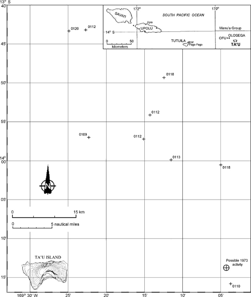 |
Figure 1. Map showing locations of nine earthquakes NE of Ta'u Island, Samoa, during January 1995. Hypocenters are labeled with the date (0112 = 12 January) of the event. Two located events not shown plot farther NW, and one to the E of the map area (see table 1). Index map modified from Stice and McCoy (1968). |
RSP seismologists believe that the swarm was volcanic because the signals are similar to the classic Monowai and Raoul T-waves: short-duration and impulsive. Submarine eruptions at Monowai Seamount were detected by T-wave signals in 1986, 1988, and 1990-91 (SEAN 13:09, BGVN 15:09, and BGVN 16:03). The stronger events in this swarm were the same amplitude as normal Monowai or Raoul T-wave signals. T-waves produced by earthquakes have much longer durations and are not impulsive. Also, this area is not seismically active; one small event was recorded in 1969 and another in 1976 (M 5.0).
The Manu'a Islands (Ta'u, Ofu, and Olosega) were built by volcanic activity along the crest of the easternmost portion of the Samoa Ridge (Stice and McCoy, 1968). This earthquake swarm was centered ~50 km NE of Ta'u Island, the emergent portion of the large Lata shield volcano; numerous Holocene post-caldera cones occur at the summit and on the flanks of this volcano. Ofu and Olosega islands, NW of Ta'u, are formed by two eroded coalescing shield volcanoes. A submarine eruption along the ridge between Olosega and Ta'u islands, ~3 km SE of the tip of Olosega Island, was reported from 12 September to the middle of November 1866. A possible submarine eruption E of Ta'u was detected by SOFAR in July 1973.
Reference. Stice, G.D., and McCoy, F.W., Jr., 1968, The geology of the Manu'a Islands, Samoa: Pacific Science, v. 22, p. 427-457.
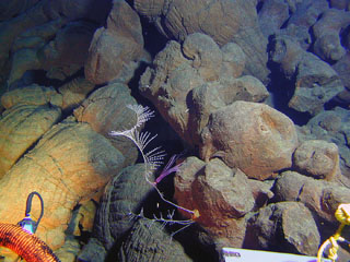
Geological Summary. Vailulu'u, a massive basaltic seamount discovered in 1975, rises 4,200 m from the sea floor to a depth of 590 m. Located about one-third of the way between Ta'u and Rose islands at the E end of the American Samoas, it is considered to mark the current location of the Samoan hotspot. The summit contains an oval-shaped crater that is 2 km wide and 400 m deep. Two principal rift zones extend E and W from the summit, parallel to the trend of the hotspot; a third rift extends SE. The rift zones and escarpments produced by mass wasting phenomena give the seamount a star-shaped pattern. On 10 July 1973 explosions were recorded by SOFAR (hydrophone records of underwater acoustic signals). An earthquake swarm in 1995 may have been related to an eruption. Eruptive activity between April 2001 and April 2005 formed a cone almost 300 m high, named Nafanua. Repeated bathymetric mapping surveys showed depth changes, including height and width increases of Nafanua after 2005, that suggest at least intermittent activity during 1999-2017; a 2019 survey showed no further changes since 2017.
Information Contacts: Francois Schindele, Laboratoire de Geophysique (LDG), B.P. 640, Papeete, Tahiti, Polynesie, France; National Earthquake Information Center (NEIC), U.S. Geological Survey.