Report on Kilauea (United States) — January 1995

Bulletin of the Global Volcanism Network, vol. 20, no. 1 (January 1995)
Managing Editor: Richard Wunderman.
Kilauea (United States) Lava flows active on coastal plain and at ocean entries
Please cite this report as:
Global Volcanism Program, 1995. Report on Kilauea (United States) (Wunderman, R., ed.). Bulletin of the Global Volcanism Network, 20:1. Smithsonian Institution. https://doi.org/10.5479/si.GVP.BGVN199501-332010
Kilauea
United States
19.421°N, 155.287°W; summit elev. 1222 m
All times are local (unless otherwise noted)
"Two large lava flows were active on the coastal plain throughout January (figure 96). These flows broke out of the active tube system on Pulama pali, on 1 December. Both flows reached the coastal plain in December, and the E flow entered the ocean on 20 December. Throughout January, the E flow entered the ocean from multiple points along a kilometer-wide front, never really consolidating into a tube entry. The W flow did not enter the ocean until 7 January, and the entries were active intermittently, eventually stagnating altogether by late January. The W flow, despite not entering the ocean, continued to be very active throughout January. There were multiple small breakouts active on this flow below Paliuli. The flow also inflated dramatically during this time, forming a prominent tumuli field. In contrast, the E flow had many large sheet flows active on the coastal plain with moderate inflation. Multiple aa and pahoehoe flows cascaded down Pulama pali during January. There were no changes at the vent area. The lava pond in Pu`u `O`o crater was active and 86 m below the crater rim."
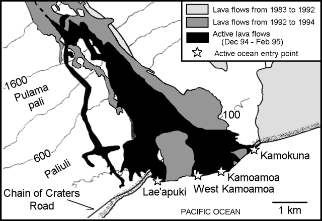 |
Figure 96. Kīlauea lava flows in the Kamoamoa area since 1982, including flows active during December 1994-February 1995. Courtesy of HVO. |
Eruption tremor levels . . . were steady just slightly above background. The number of LPC-A (shallow long-period, 3-5 Hz) microearthquakes was moderate to high during 12-18 Jan; low-level amplitudes persisted throughout, with minor fluctuation. Daily counts of microearthquake activity remained low beneath the summit and rift zones except for the LPC-A category, with only a very small number large enough to process for location.
Geological Summary. Kilauea overlaps the E flank of the massive Mauna Loa shield volcano in the island of Hawaii. Eruptions are prominent in Polynesian legends; written documentation since 1820 records frequent summit and flank lava flow eruptions interspersed with periods of long-term lava lake activity at Halemaumau crater in the summit caldera until 1924. The 3 x 5 km caldera was formed in several stages about 1,500 years ago and during the 18th century; eruptions have also originated from the lengthy East and Southwest rift zones, which extend to the ocean in both directions. About 90% of the surface of the basaltic shield volcano is formed of lava flows less than about 1,100 years old; 70% of the surface is younger than 600 years. The long-term eruption from the East rift zone between 1983 and 2018 produced lava flows covering more than 100 km2, destroyed hundreds of houses, and added new coastline.
Information Contacts: T. Mattox and P. Okubo, HVO.