Report on Rabaul (Papua New Guinea) — February 1995

Bulletin of the Global Volcanism Network, vol. 20, no. 2 (February 1995)
Managing Editor: Richard Wunderman.
Rabaul (Papua New Guinea) Renewed eruptive activity at Tavurvur
Please cite this report as:
Global Volcanism Program, 1995. Report on Rabaul (Papua New Guinea) (Wunderman, R., ed.). Bulletin of the Global Volcanism Network, 20:2. Smithsonian Institution. https://doi.org/10.5479/si.GVP.BGVN199502-252140
Rabaul
Papua New Guinea
4.2459°S, 152.1937°E; summit elev. 688 m
All times are local (unless otherwise noted)
"Eruptive activity resumed at Tavurvur on 13 February after one and a half months of quiescence; no precursory activity was detected. Following the end of the 1994 eruption on 23 December, Tavurvur had exhibited only fumarolic activity. The amount of vapour released declined during January and emissions became intermittent in the first half of February. Seismicity was low, although some volcanic earthquakes continued to be recorded. The deflation rate of the caldera was also extremely low.
"After about 0100 on 13 February, small explosions started from Tavurvur's 1994 crater. Activity increased during the early hours of the morning, and large explosions occurred at 0328, 0857, 0919, 0937, 1012, 1100, and 1230. Each of these lasted 2-3 minutes and generated ash clouds that rose 1,500-3,000 m above the crater. Some of the ash clouds were laced with lightning. Ballistic blocks were seen falling onto the flanks of the cone and into the sea around Tavurvur. Between the larger explosions, emissions were less energetic or in "puffs" over periods of 5 minutes or more. After the first day, the emissions generally rose 500-1,000 m above the crater and were blown SE, producing a 10-km-long discontinuous, diffuse, pale-grey plume.
"Each of the explosions was accompanied by a distinctive explosive or low-frequency earthquake whose amplitude corresponded to the size of the explosion. Changes in the eruptive activity could therefore be tracked using RSAM data from station KPTH on Matupit Island (figure 23). An analysis of RSAM 1-minute data produced the event counts and mean amplitudes shown in figure 23. These showed that after a few hours of large events, at an average rate of ~10/hour, the activity was dominated by smaller explosions that peaked after about a day and a half on 14 February, at an average rate of 15/hour. The number of explosions and their amplitude then declined over the next 2-3 days. On 17 and 18 February, however, the activity increased again, perhaps associated with heavy rain on the 16th and 17th. The event count stayed fairly constant until the end of the month, although event amplitudes exhibited a slowly increasing trend.
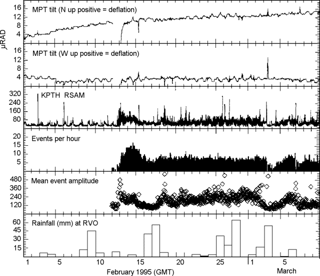 |
Figure 23. Rabaul tilt and seismicity measured at stations MPT and KPTH on Matupit Island, 1 February-10 March 1995. Positive N and W tilts indicate deflation of the caldera. Note that times are GMT (= local time - 10 hours). Courtesy of RVO. |
"Apart from the low-frequency explosive events associated with the Tavurvur eruption, earthquake activity at Rabaul was very low in February. There were only four small high-frequency earthquakes recorded, compared to 28 in January. Two were located at shallow depths near Vulcan and the other two were outside the seismic network to the NE.
"Throughout the first part of February, ground deformation data continued to show the slowing deflationary trend seen since September 1994, with the deflation centered S of Matupit Island. Electronic tilt data from station MPT on Matupit Island showed deflation of ~0.5 µrad/day during this period (figure 23). Seashore survey measurements around Greet Harbour were in good agreement, with subsidence of <1 cm/month. Following the renewal of activity at Tavurvur, ground deformation rates seem to have decreased, with only 3 µrad of tilt at MPT in 3 weeks, and no measurable changes in seashore levelling data. The gap in the tilt data on figure 23 was because the battery at MPT was stolen the day before the explosive activity began.
"There were three aerial inspections of Tavurvur during this period. On the morning of 13 February, before the large explosions took place, there was no marked change in the configuration of the bowl-shaped crater compared to the previous inspection in January. There also was no open vent, although the explosive emissions rose through the central part of the crater floor, which was covered with ash and rubble. On 20 February, emissions were seen rising from an obstructed vent in the SE part of the crater, while a strong fumarole was active on the W side of the crater (at the head of the 1994 lava flow). A small mound of lava seen on the 27th at the base of the crater was 20-30 m wide, only a few meters high, and was partly mantled with ash. Emissions were released through cracks in the lava or from between blocks near the edges.
"Throughout February, Vulcan continued to exhibit only very weak fumarolic activity from diffuse sources around the edge of the floors of both the 1937 and 1994 craters. At some time in late January or February, hot steaming springs appeared along the N shore of the Vulcan headland. Measured temperatures were consistently around 100°C.
"The Gazelle Peninsula has remained under a State of Emergency, with access to Rabaul controlled because of the risk from mudflows and flooding. Although the rainy season has been unusually mild so far, mudflows and flash floods are causing much damage to the roads into Rabaul and are flooding the remaining buildings in the town and in nearby villages."
Geological Summary. The low-lying Rabaul caldera on the tip of the Gazelle Peninsula at the NE end of New Britain forms a broad sheltered harbor utilized by what was the island's largest city prior to a major eruption in 1994. The outer flanks of the asymmetrical shield volcano are formed by thick pyroclastic-flow deposits. The 8 x 14 km caldera is widely breached on the east, where its floor is flooded by Blanche Bay and was formed about 1,400 years ago. An earlier caldera-forming eruption about 7,100 years ago is thought to have originated from Tavui caldera, offshore to the north. Three small stratovolcanoes lie outside the N and NE caldera rims. Post-caldera eruptions built basaltic-to-dacitic pyroclastic cones on the caldera floor near the NE and W caldera walls. Several of these, including Vulcan cone, which was formed during a large eruption in 1878, have produced major explosive activity during historical time. A powerful explosive eruption in 1994 occurred simultaneously from Vulcan and Tavurvur volcanoes and forced the temporary abandonment of Rabaul city.
Information Contacts: P. de Saint-Ours, R.Stewart, and B. Talai, RVO.