Report on Merapi (Indonesia) — February 1995

Bulletin of the Global Volcanism Network, vol. 20, no. 2 (February 1995)
Managing Editor: Richard Wunderman.
Merapi (Indonesia) Seismic data associated with the 22 November 1994 dome collapse
Please cite this report as:
Global Volcanism Program, 1995. Report on Merapi (Indonesia) (Wunderman, R., ed.). Bulletin of the Global Volcanism Network, 20:2. Smithsonian Institution. https://doi.org/10.5479/si.GVP.BGVN199502-263250
Merapi
Indonesia
7.54°S, 110.446°E; summit elev. 2910 m
All times are local (unless otherwise noted)
Workers at the GMU Geophysical Laboratory and Martin Beisser of GFZ-Potsdam recorded seismic data during the [summit lava dome] collapse from their station at Klathakan, 1.8 km WNW of the summit. Their broad-band seismic instrument showed the associated disturbance beginning on 22 November at 1007 and 32 seconds (radial-component data shown on figure 14). So far as the GMU and GFZ workers know, the wide dynamic range of their broad-band instrument preserved the event with a minimal amount of high-amplitude signal "clipping." Also, in their interpretation, the collapse and seismic disturbance began simultaneously. In other words, the initial displacement at the beginning of the seismic record is thought to correspond to the arrival of signals from the inception of the collapse.
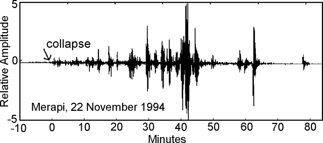 |
Figure 14. Seismic record for the Merapi 22 November 1994 dome collapse. The component shown is horizontal, radial to the edifice; amplitude scale is arbitrary. The data were recorded on a data logger connected to a Streckeisen STS2 seismometer (with a 50 Hz sampling rate, a 8.33 mHz to 50 Hz linear response, and a 32-bit analog-to-digital converter). Courtesy of A. Brodscholl and K. Brotopuspito. |
The collapse-related seismic event lasted for almost an hour (figure 14). The initial signals were set against a moderately quiet background, and maximum amplitude generally increased with time. Highest-amplitude signals were received ~40 minutes after the event began. These largest signals had amplitudes that reached approximately 30 mm/second, whereas at the beginning of the collapse the maximum amplitudes were only ~0.05 mm/second. Thus, on the seismic records, amplitudes ultimately grew to 600x as large as the initial signals.
The eruption and collapse also appear in a 200-hour time window showing measured seismic amplitude in specified wavelengths (figure 15). The figure was prepared using signal processing techniques, which for the high frequency (0.1-1.0 Hz) data involved significant averaging of the maximum values (to once an hour). These depictions show that one or two noteworthy seismic disturbances took place at ~150 and 180 hours prior to the collapse (cause unknown). Compared to the other seismic disturbances on these records, the collapse and eruption induced larger amplitude and much more sustained signals. The post-collapse signals were also followed by an interval of at least 10 hours of elevated background (most noticeable in the 1-12 Hz range).
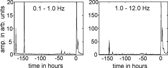 |
Figure 15. Radial component of the Merapi 22 November 1994 dome collapse showing a seismic amplitude (arbitrary scale) versus time for stated wavelength ranges. The inception of the collapse lies at the zero point of the time scale. Courtesy of A. Brodscholl and K. Brotopuspito. |
Using the available data, the investigators failed to find any clearly related premonitory seismic signals for the collapse. Sufficient collateral data (for example, teleseismic and meteorological data) might help constrain detected collapse and eruption earthquakes, or shed light on the cause of the pre-collapse seismic disturbances.
Since our last report (19:12), continued dome building occurred at Merapi. On 5 January another collapse brought 1 x 10⁶ m3 of debris downslope. This collapse produced a small pyroclastic flow on the S slope.
Geological Summary. Merapi, one of Indonesia's most active volcanoes, lies in one of the world's most densely populated areas and dominates the landscape immediately north of the major city of Yogyakarta. It is the youngest and southernmost of a volcanic chain extending NNW to Ungaran volcano. Growth of Old Merapi during the Pleistocene ended with major edifice collapse perhaps about 2,000 years ago, leaving a large arcuate scarp cutting the eroded older Batulawang volcano. Subsequent growth of the steep-sided Young Merapi edifice, its upper part unvegetated due to frequent activity, began SW of the earlier collapse scarp. Pyroclastic flows and lahars accompanying growth and collapse of the steep-sided active summit lava dome have devastated cultivated lands on the western-to-southern flanks and caused many fatalities.
Information Contacts: A. Brodscholl and K. Brotopuspito, GMU; M. Beisser, GFZ-Potsdam, Germany; W. Tjetjep, VSI.