Report on Llaima (Chile) — February 1995
Bulletin of the Global Volcanism Network, vol. 20, no. 2 (February 1995)
Managing Editor: Richard Wunderman.
Llaima (Chile) Minor fumarolic activity; small scoria cone collapsed in the crater
Please cite this report as:
Global Volcanism Program, 1995. Report on Llaima (Chile) (Wunderman, R., ed.). Bulletin of the Global Volcanism Network, 20:2. Smithsonian Institution. https://doi.org/10.5479/si.GVP.BGVN199502-357110
Llaima
Chile
38.692°S, 71.729°W; summit elev. 3125 m
All times are local (unless otherwise noted)
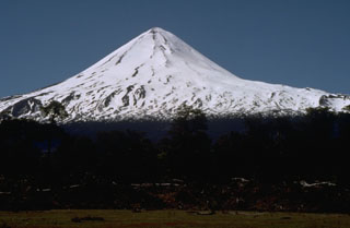
One of the most active volcanoes in Chile, Llaima's last reported eruptive episode began on 17 May 1994. An overflight made in the late morning of 15 February (in conjunction with Simon Young and John Simmons) disclosed only minor fumarolic activity. The fumarolic activity focused on the N internal wall of the main crater. In accord with the minor fumarolic activity, no new ash was seen. The summer ice melt has exposed the May and August 1994 scoria deposits (BGVN 19:04, 19:05, and 19:08), layers blackening the glaciers and rocks on the volcano's slopes. Along the crater's SSW border, a roughly 200-m-deep notch exposed alternating lava and tephra layers that mantle the edifice. A small scoria cone surrounding the source vent sat in the SE portion of the crater after the 26-30 August 1994 eruption. That feature later collapsed without leaving a visible trace. The crater itself had a depth of ~350 m.
The episode that began on 17 May 1994 generated a Strombolian-to-subplinian eruption with associated lahars and flooding, and produced a column ~4-5 km above the summit. Tephra fell over a cigar-shaped zone trending about ESE. A 500-m-long, SW-trending fissure produced explosions and lava fountains. Lava flowed across the bottom of a glacier on Llaima's W flank, melting snow and ice that caused lahars to descend into the Calbuco and Quepe rivers. Flooding occurred farther from the volcano.
Geological Summary. Llaima, one of Chile's largest and most active volcanoes, contains two main historically active craters, one at the summit and the other, Pichillaima, to the SE. The massive, dominantly basaltic-to-andesitic, stratovolcano has a volume of 400 km3. A Holocene edifice built primarily of accumulated lava flows was constructed over an 8-km-wide caldera that formed about 13,200 years ago, following the eruption of the 24 km3 Curacautín Ignimbrite. More than 40 scoria cones dot the volcano's flanks. Following the end of an explosive stage about 7200 years ago, construction of the present edifice began, characterized by Strombolian, Hawaiian, and infrequent subplinian eruptions. Frequent moderate explosive eruptions with occasional lava flows have been recorded since the 17th century.
Information Contacts: Jose Antonio Naranjo, Servicio Nacional de Geologia y Mineria, Avenida Santa Maria 0104, Casilla 1347, Santiago, Chile.